

5 p.m. Update: Three-C Expected to Become Tropical Storm Kilo by Tomorrow
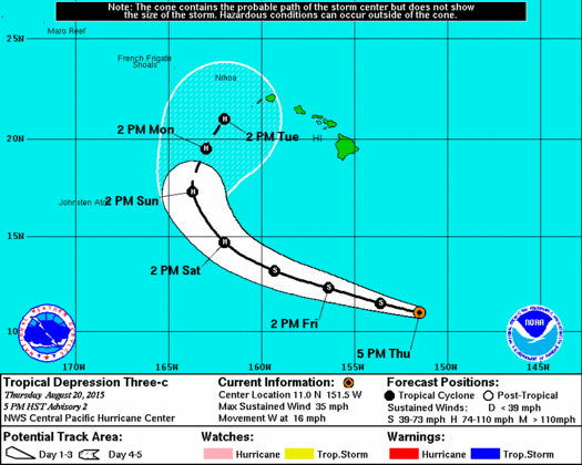
CPHC 5 p.m. track for Three-C
***Updated at 5:00 p.m.***
Tropical Depression Three-C has held steady with maximum sustained winds at 35 mph with higher gusts. The system is located 775 miles SSE of Hana, 800 miles SSE of Kahului, 830 miles SSE of Kaunakakai, 810 miles SSE of Lanai City.
The system is moving west near 16 mph and expected to take a WNW motion the next two days.
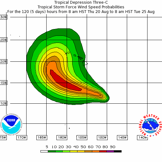
Three-C tropical wind speed probabilities
The CPHC has low confidence in where the exact center is located so future movement is also uncertain at this point. Forecast guidance from the 11 a.m. update holds true (see below for details).
Hurricane Hunters are expected to make their first pass through the system to provide valuable information and data on the storm Friday evening.
The main change since the last update is the track has been adjusted south from the previous forecast track.
The latest forecast discussion released by the National Weather Service indictes models are showing a renewed surge of deep moisture pushing back up the chain from SE to NW on the edges of the tropical depression starting Friday night which is likely to bring bands of showers back in over the state. The trade winds will increase further to breezy levels as well.
Our local forecast early next week will continue to be heavily based on the six-hourly updates to the official CPHC forecast track and intensity of this system. Our latest forecast, based on the 11 am advisory, shows the possibility of tropical storm conditions for Niihau, Kauai, Oahu, and Molokai in the Monday/Monday night time frame. In addition to the wind threat, we would expect to see rainbands and embedded thunderstorms extending well to the east of the track of the depression.
It is very important to consider that forecasts at longer ranges have a large margin of error, with an average of nearly 300 miles at 5 days, and roughly 200 miles at 4 days. Do not get hung up on any precise track. Always consider alternate possibilities using both the error cone and wind speed probabilities and prepare as needed.
***Updated at 11:00 a.m.***
Tropical Depression Three-C has developed sufficient deep convection around a closed circulation to be considered a tropical depression.
This is the sixth tropical cyclone in the Central North Pacific basin for the 2015 season. If the circulation becomes more prevalent and the system strengthens into a tropical storm, it would take on the Hawaiian name Kilo.
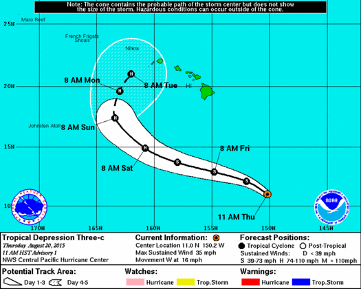
Image: CPHC 11 a.m. track THREE-C
Tropical Depression Three-C has maximum sustained winds at 35 mph with higher gusts. The system is located 775 miles SSE of Hāna, 800 miles SSE of Kahului, 830 miles SSE of Kaunakakai and 810 miles SSE of Lānaʻi City.
The system is moving west near 16 mph and expected to take a WNW motion next two days. The CPHC has low confidence in where the exact center is located so movement is also uncertain at this point. Hurricane Hunters are expected to make their first pass through the system to provide valuable information and data on the storm Friday evening.
Some upper level easterly winds are affecting the system right now, however, this shear is expected to decrease over the next two to three days. The system is also expected to pass over very warm waters which will further help to strengthen the system. Steady development is expected with the forecast calling for Three-C to become a tropical storm within the next 24 hours and a hurricane in about two days.
The concerning part of the forecast is with regards to the forecast track. There is a lot of uncertainty when it comes to the weather features that are expected to steer the system. A weakness in the ridge is expected to develop. When this occurs, the system is expected to slow down in forward speed and turn toward the north or north-northeast. For now, weather models are not in agreement as to when this will happen. The timing depends on when the weakness happens. The longer it takes for this to occur, the farther west the system will travel before making the turn.
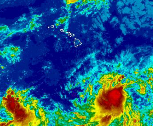
Image: NWS Satellite of Three-C at 8:45 a.m.
***Updated at 10 a.m.***
National Weather Service Forecaster, Bob Ballard, just issued his latest forecast discussion and had this to say about the developing tropical cyclone to our southeast.
Moisture on the periphery of the developing tropical cyclone may start to bring increasing showers and humidity this weekend. The forecast for early next week is highly dependent on the eventual track and intensity of this system. The models are indicating a surge of deep moisture pushing back up the chain from SE to NW on the periphery of the tropical cyclone starting Friday night which will likely bring bands of showers back in over the state. The trade winds will increase further possibly to fresh/strong levels.
Our local forecast early next week will be heavily based on the six-hourly updates to the official CPHC forecast track and intensity of this system. It is very important to consider that forecasts at longer ranges have a large margin of error, with an average of nearly 300 miles at 5 days and roughly 200 miles at 4 days. Do not get hung up on any precise track and always consider alternate possibilities using the error cone and wind speed probabilities and prepare as needed.
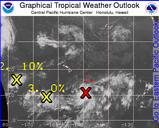
Image: CPHC Tropical Depression Three-C develops in Central Pacific
***Updated at 8:30 a.m.***
By Meteorologist Malika Dudley
The Central Pacific Hurricane Center will be initiating advisories at 11 am HST on newly formed tropical depression Three-C (Formerly Invest 93C), located about 700 miles southeast of Hilo, Hawaii or about 900 miles southeast of Honolulu. We will update this when the information is available.
The National Weather Service says the forecast for the weekend remains highly uncertain, due to the uncertain track of a tropical system southeast of the islands. There are still significant disagreements between long-range models upon how this scenario will evolve. It is still too early to determine what impacts will be felt in the islands from this potentially developing disturbance. Either scenarios do hint a possible increase in the rain chances for the islands. The latest forecasts should be monitored closely, especially if making outdoor plans for the upcoming weekend.
Sponsored Content


