

Niala Prompts Wind Advisory, Isolated Heavy Showers Possible

Image: Asa Ellison
***Updated at 2 p.m.***
Isolated showers, sometimes heavy, are forecast to pass through Maui County. Heaviest rains will most likely occur later tonight and into Sunday along the north and east as enhanced moisture from Niala passes through.
***Updated at 10 a.m.***
A Wind Advisory has been issued through 6 a.m. Monday for easterly winds between 25 and 35 mph. Higher gusts are possible. Strongest winds will be in areas exposed to the trade winds.
A tight pressure gradient between nearing Niala (to the east) and a strong high pressure system( to the north of the state) will produce windy conditions across the smaller islands through Sunday night.
Winds this strong can break tree branches, blow loose objects around and weak structures may blow around or break. Take precautions now.
Alerts
A Small Craft Advisory is posted for all Maui County waters through 6 a.m. Monday. East winds up to 25 knots are expected along with rough seas of up to 12 feet. Inexperienced mariners should avoid navigating in these conditions.
A High Surf Advisory is posted for easterly exposures with wave heights of 5 to 8 feet or more expected through 6 a.m. Monday. The surf is forecast to build Saturday, peak Saturday night and Sunday and fade Sunday night into Monday.
**Click directly on the images below to make them larger. Charts include: Maui County high/low forecasted temperatures, projected winds, projected localized weather conditions and expected wave heights.**
Looking Ahead
Breezy trade winds are expected to keep most showers focused over windward slopes into next week, though afternoon showers also will occur over some lee slopes. The track of Niala has the potential to change our forecast. For now, the system should turn west and pass to the south over the weekend. If the forecasts holds, winds could kick up a notch maybe even reaching tropical storm strength in some areas of the Big Island. A moist and unstable air mass from the deep tropics likely will bring heavy showers and thunderstorms to the Big Island into next week. Southeast slopes are expected to get heavy rain and possible thunderstorms. Models are yet certain how far north this moisture will be able to push. Will keep you up to date.
Today
We expect mostly cloudy skies today with numerous showers in windward and mauka spots. Leeward areas in Maui County may see scattered showers with partly cloudy skies. High temperatures from 86° to 91°. Breezy east winds are expected from 15 to 25 mph.
UV index at 11 (“extreme” exposure level)
Tonight
East winds are expected this evening from 15 to 25 mph. Low temperatures from 73° to 78°. Partly to mostly cloudy skies are expected in the evening with numerous showers for windward spots and scattered showers for leeward areas.
Our Maui Now Weather homepage always includes daily: Sunrise | Sunset | Moonrise | Moonset | Moon Phase | Live Weather Cams | 5-day Forecast | Current Temperature & Conditions
***Click here for your marine outlook and surf report.***

Image: NOAA / NWS

Image: NOAA / NWS

Image: NOAA / NWS
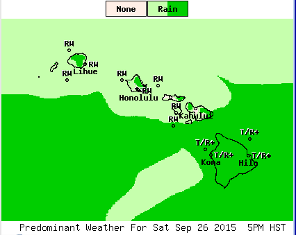
Image: NOAA / NWS

Image: NOAA / NWS
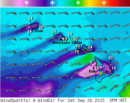
Image: NOAA / NWS

Image: NOAA / NWS

Image: NOAA / NWS
Sponsored Content


