

Trade Winds Pick Back up Today, 25 mph +

Image: Chris Archer
Alerts (as of 1:00 a.m.)
A Small Craft Advisory is posted for the ʻAlenuihāhā & Pailolo channels, as well as Māʻalaea Bay through 6 p.m. Tuesday.
**Click directly on the images below to make them larger. Charts include: Maui County high/low forecasted temperatures, projected winds, projected localized weather conditions and expected wave heights.**
Looking Ahead
Moderate to breezy trade winds will continue through Wednesday. Clouds and showers should favor mainly windward and mauka areas, with an increase in shower activity expected Tuesday night and Wednesday as moisture from the remnants of an old front moves through. A late season front is expected to approach Thursday, causing our winds to weaken and veer to the southeast. The front may stall near Kauai late this week, then dissipate with trade winds returning during the weekend.
Today
We expect partly cloudy skies with scattered windward showers in the morning. Partly sunny for the leeward sides. Northeast winds are expected from 15 to 25 mph with higher gusts. High temperatures from 83° to 88°.
UV index at 12 (“extreme” exposure level)
Tonight
East winds are expected around 10 to 20 mph. Mostly cloudy skies are expected with windward showers likely and isolated leeward showers. Low temperatures from 70° to 75°.
Our Maui Now Weather homepage always includes daily: Sunrise | Sunset | Moonrise | Moonset | Moon Phase | Live Weather Cams | 5-day Forecast | Current Temperature & Conditions
***Click here for your marine outlook and surf report.***

Image: NOAA / NWS

Image: NOAA / NWS

Image: NOAA / NWS

Image: NOAA / NWS
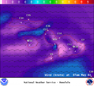
Image: NOAA / NWS
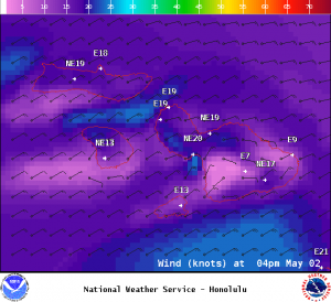
Image: NOAA / NWS

Image: NOAA / NWS
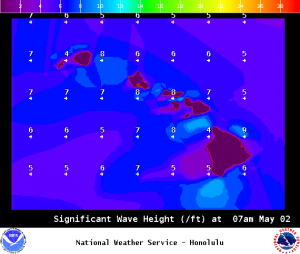
Image: NOAA / NWS
Sponsored Content


