

Malika Dudley’s Daily Maui County Forecast – 10/20/14
By Meteorologist Malika Dudley / Email: malika@mauinow.com
Alerts
A HIGH SURF ADVISORY is posted for the north facing shores of Maui and Molokaʻi until noon today.
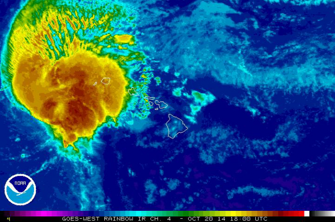
Tropical storm ANA moves away from the islands. Satellite image, October 20, 2014 / NOAA
ANA Rainfall and Wind Re-cap
Rainfall rates recorded during Hurricane Ana’s passage ranged up to about 3.5 inches in Maui County. Here is the breakdown: Maui – Kula 3.54″, Puʻu Kukui 3.08″, Kepuni 2.45″, ʻUlupalakua 1.92″, Pukalani 0.79″, Kahului 0.44″; Molokaʻi – Puʻu Aliʻi 3.22″, Kaunakakai 1.08″; Kahoʻolawe – 3.25″; Lānaʻi – 2.09″.
Wind gusts up to 36 mph were recorded in Kahului, 35 mph for Lānaʻi City and 39 mph at the Molokaʻi Airport.
Today
We expect partly cloudy skies today with scattered showers. High temperatures should fall in the range of 82° to 87° with winds out of the east at about 15 mph. The leeward sides of our islands will experience lighter winds and an afternoon sea breeze is expected to take hold possibly bringing some afternoon clouds and showers for leeward and interior areas. At higher elevations, temperatures of 2° to 4° lower can be expected.
Sunset this evening at 5:58 p.m.
Sunrise tomorrow at 6:23 a.m.
UV index at 6 (“high” exposure level)
Tonight
Cloud cover is expected to increase with scattered showers in the forecast. Only isolated showers for leeward spots after midnight. Low temperatures should fall in the range of 73° to 78° and winds are expected to still be out of the east at about 15 mph.
Looking Ahead
A moderate easterly and southeasterly flow is expected to begin establishing during the next couple of days. Then light to moderate trades should prevail for the second half of the week with a hybrid pattern setting up. Showers are expected to favor windward and mountain areas in the morning and evening hours with isolated interior and leeward showers in the afternoons. Muggy conditions are likely during this time. Long-range forecasts are subject to more error and will be updated daily to reflect any changes in model guidance.

Maliko to Kahului paddle on Sunday, Oct. 19, 2014. Photo by Lee Moyers.
Surf & Seas
An above average north-northwest swell affecting Maui and Molokaʻi’s north shores is expected to peak this afternoon at about 10 to 15 foot faces. The swell should gradually fade through midweek. Beach goers should expect breaking waves, shore break conditions and strong long shore and rip currents making swimming difficult and dangerous today.
Swell generated by ANA continues to drop and a small SSW is expected to build in for tomorrow offering heights in the knee to waist high range. For now, just ankle slappers.
Almanac
Maximum Temperature for today:
Normal 87°
Record 93° / Set in 1984 and tied in 1996
Minimum Temperature for today:
Normal 69°
Record 61° / Set in 1950 and tied in 1950
Sponsored Content


