Malika Dudley’s Weather Forecast – Wednesday 10/22/14
By Meteorologist Malika Dudley / Email: malika@mauinow.com
Connect with Malika on Facebook, Twitter and Instagram.
**A breakdown of expected conditions specific to Maui County is presented below in graphical form. High and low temperatures, swell, percent chance of clouds / rain and wind conditions are each depicted. All graphics are provided by the National Weather Service in Honolulu.**

Maui rainbow / Image: Kitrick Short
Alerts
There are no alerts posted for Maui County at this time.
Today
We have another muggy, sticky, humid day in store for us. Partly to mostly cloudy skies are expected with scattered windward and mauka showers. Less than 1/4″ of rain is forecasted for windward spots on Maui. For the leeward sides, mostly sunny skies are expected in the morning. Daytime heating will likely create a sea breeze that will produce cloud cover for leeward and interior areas in the afternoon. Showers squeezed out of these clouds could be more active than they were yesterday due to moisture from an old front in our area. Any extra rain will remain light because the atmosphere is quite stable.
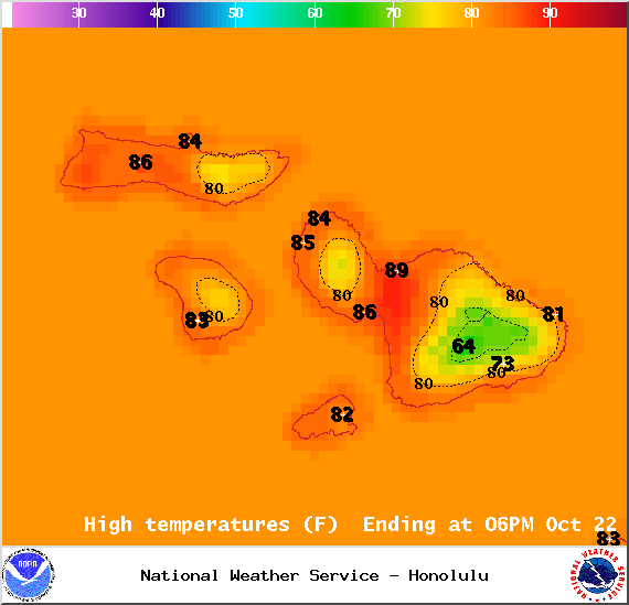
Map of expected high temperatures in Maui County on Wednesday October 22, 2014 / Image: NOAA / NWS
Less than 1/10″ of rain is expected through the central valley, south and west shores of Maui. Lānaʻi and west Molokaʻi can also expect less than 1/10″ of rain today. High temperatures should fall in the range of 84° to 89° with higher elevations experiencing lower temperatures. The Big Island is partially blocking the east-southeast wind flow so light and variable winds up to 15 mph are expected for Maui County.
Sunset tonight at 5:58 p.m. Sunrise tomorrow at 6:23 a.m.
UV index at 9 (“very high” exposure level)

Map of expected overnight low temperatures in Maui County on Wednesday October 22, 2014 / Image: NOAA / NWS
Tonight
Cloud cover is expected to increase with scattered showers likely for windward and mauka areas. Low temperatures should fall in the range of 73° to 78° and winds are expected to be variable up to 15 mph.
Looking Ahead
Muggy in the short term but some relief is in sight. A high pressure system, which generates our trade winds, is expected to build on Thursday. As the high builds, trade winds will pick up in strength as well. The trades may be short-lived with pressure gradients slacking over the weekend and into early next week.

Expected wind conditions at 7am in Maui County on Wednesday October 22, 2014 / Image: NOAA / NWS
Surf & Seas
Our current north swell (345-360°) is fading and mixing with a shorter-period northwest swell. We expect surf heights in the waist to chest high range. Another north-northwest (320-360°) swell is on its heels expected to begin building through the day on Thursday.

Expected wind conditions at 4pm in Maui County on Wednesday October 22, 2014 / Image: NOAA / NWS
A south-southwest (200-190°) swell is moving in offering knee to possibly chest high waves at our best exposed shores. This swell is expected to peak tomorrow and Thursday, then the south goes quite for a few days. Gales well southeast of New Zealand could bring larger surf by the middle of next week.
If ANA continues on its current forecast track the remnants of ANA are expected to merge with a storm to our north. If that happens we may see some swell generated from “ANA.”
Keep in mind, surf heights are measured on the face of the wave from trough to crest. Heights vary from beach to beach, and at the same beach, from break to break.
Almanac for Kahului Airport
Maximum Temperature for today:
Normal 87°
Record 92° / Set in 2009
Minimum Temperature for today:
Normal 69°
Record 58° / Set in 1953

Percent chance of cloud cover at 7am in Maui County on Wednesday October 22, 2014 / Image: NOAA / NWS

Percent chance of cloud cover at 4pm in Maui County on Wednesday October 22, 2014 / Image: NOAA / NWS

Percent chance of rain at 4pm in Maui County on Wednesday October 22, 2014 / Image: NOAA / NWS

Percent chance of rain at 7am in Maui County on Wednesday October 22, 2014 / Image: NOAA / NWS
Sponsored Content