Trade Winds Expected Back

Up Country Jacaranda / Image: Jimmie Hepp
By Meteorologist Malika Dudley / Email: malika@mauinow.com
Alerts
FLOOD ADVISORY UNTIL 12:45 p.m. 4/27/15: A flood advisory is in effect for the Island of Maui until 12:45 p.m. on Monday, April 27, 2015. At 9:36 a.m., forecasters with the National Weather Service said radar showed showers across the windward West Maui Mountains had become lighter; however, stream gauges in these areas remained elevated. Other locations in the advisory include but are not limited to: Kanahā Beach Park, Wailuku, Waiheʻe, Waiehu, Spreckelsville, Paʻuwela, Pāʻia, Nāpili, Kapalua, Kahakuloa, Kāʻanapali, Huelo, Hoʻokipa Beach Park, Honolua, Honokōwai, Honokōhau, and Haʻikū.
A High Surf Advisory is posted for north and east facing shores of Maui and Moloka’i from 6:00 a.m. Monday through 6:00 p.m. Tuesday. Surf is expected to rise to 10 to 15 foot faces along north shores and 6 to 9 feet along east facing shores. Expect strong breaking waves, shore break and strong longshore and rip currents making swimming difficult and dangerous.
A Small Craft Advisory is posted for all Maui County channels, Maui County windward waters and Māʻalaea Bay through 6:00 a.m. Tuesday. Northeast winds up to 25 knots are forecasted along with rough seas of 8 to 15 feet. Inexperienced mariners should avoid navigating in these conditions.
**Click directly on the images below to make them larger. Charts include: Maui County high/low forecasted temperatures, projected winds, projected localized weather conditions and expected wave heights.**
Today
Mostly cloudy skies are expected today with showers likely for windward and mauka spots in the morning with scattered showers forecasted for the afternoon. Showers could pass leeward as well, though for now the forecast is calling for partly cloudy skies with scattered showers in the morning and isolated showers in the afternoon. The haze we have been experiencing is expected to clear by the afternoon. Northeast winds from 15 to 25 mph are expected with gusts as high as 35 mph. High temperatures from 80° to 85° near shore and lower high temperatures at higher elevations (see graphic above).
UV index at 11 (“extreme” exposure level)
Tonight
Mostly cloudy in windward and mauka spots with scattered showers. Partly cloudy for leeward areas with isolated showers. Low temperatures from 68° to 73°.
Looking Ahead
A slow-moving front is spreading modest rain from the Kaiwi Channel to the Big Island through Monday night. Light southerly winds ahead of the front are forecasted to turn into breezy trade winds behind it. As the frontal cloud band falls apart, much of the moisture is expected to get caught in the trade winds. The winds in turn are expected to carry this moist air mass over the state again, bringing rainfall over windward slopes. Lee areas should experience some drying by mid-week, but a few showers will continue to drift leeward before dissipating. Conditions are expected to remain on the wet side of usual through the forecast period.
Our Maui Now Weather homepage always includes daily: Sunrise | Sunset | Moonrise | Moonset | Moon Phase | Live Weather Cams | 5-day Forecast | Current Temperature & Conditions
**Click here for your marine outlook and surf report.**
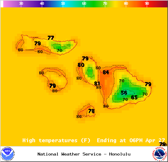
Image: NOAA / NWS

Image: NOAA / NWS
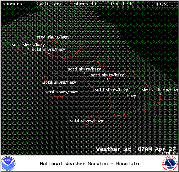
Image: NOAA / NWS
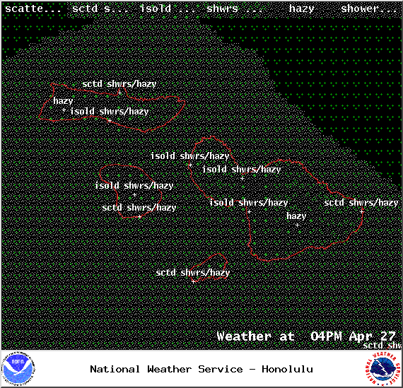
Image: NOAA / NWS
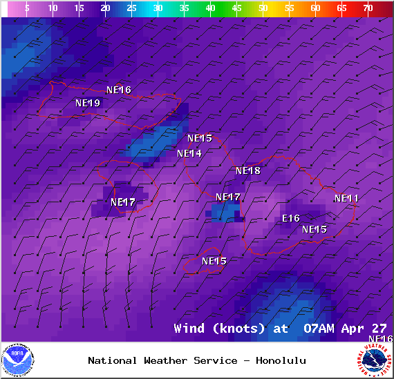
Image: NOAA / NWS

Image: NOAA / NWS
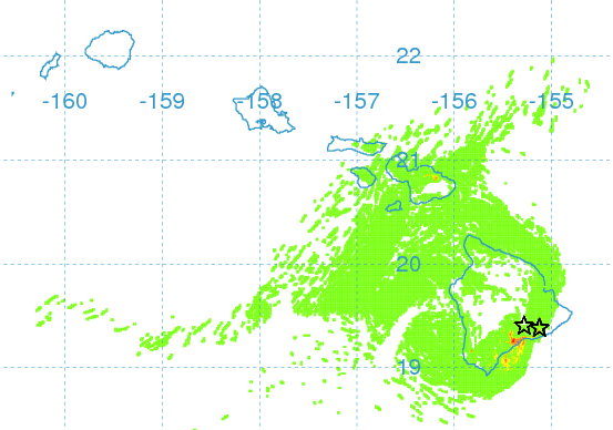
Image: UHSOEST / early morning volcanic haze forecast, clearing by afternoon
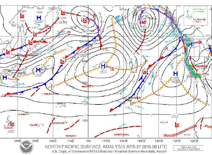
Image: NOAA / NWS
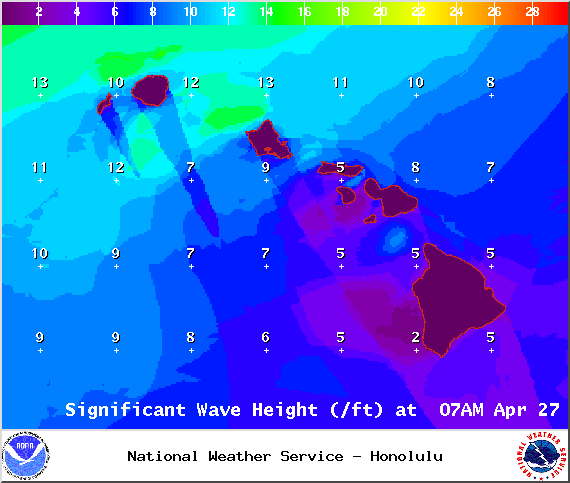
Image: NOAA / NWS
Sponsored Content