

8 p.m. UPDATE 8/3/15: Guillermo
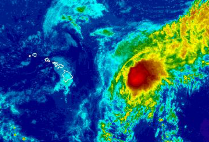
Image: NWS Satellite at 9:30 p.m.
By Meteorologist Malika Dudley / Email: malika@mauinow.com
*** Updated at 8 p.m. to include information from the Central Pacific Hurricane Center’s 8 p.m. intermediate update. ***
Guillermo has maximum sustained winds at 65 mph with higher gusts and steady weakening is still expected. continues to move northwest at 10 mph. This motion is expected to continue through Wednesday. On this forecast track the center of Guillermo is expected to pass about 140 miles northeast of the Big Island on Wednesday and about 100 miles northeast of Maui on Wednesday night.
Tropical Storm conditions are possible on the Big Island of Hawaii and in Maui County on Wednesday. Total rainfall amounts of 1 to 3 inches with isolated maximum amounts near 7 inches (in higher terrain) are possible. Large swells ahead of the system are expected through midweek.
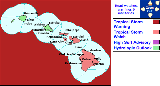
Tropical Storm Watch issued for Maui County / Big Island. Image courtesy NWS/NOAA.
***Updated at 5:00 p.m. to include information from the National Weather Service and Central Pacific Hurricane Center update.***
The watch was issued at 5 p.m. by the CPHC for Maui County. A Tropical Storm Watch means that tropical storm conditions are possible within the next 48 hours somewhere within the specified areas.
A watch is typically issued before the possible arrival of tropical storm force winds which make continuing outside preparations dangerous. A watch is the time for you to prepare.
All of Maui County is under this watch at this time.
The Central Pacific Hurricane Center stated in their latest update, “while the forecast track keeps the center of Guillermo northeast of the main Hawaiian Islands, a significant deviation to the left of the track would have the potential to bring tropical storm conditions to the Big Island and Maui County. When accounting for the size of the system, there remains enough uncertainty to warrant issuance of a Tropical Storm Watch for Hawaii and Maui Counties. Other counties may be added later as needed.”
The National Weather Service says “It is vital that you do not focus on the exact forecast track. Forecast movement, direction and speed are only estimates. Even small shifts in the track can mean major differences in where the worst conditions will occur. Damaging effects can extend far from the center.”
Guillermo is currently 615 miles ESE of Kahului, 670 miles ESE of Kaunakakai and 645 miles ESE of Lanai City. Maximum sustained winds are at 65 mph and the system is moving NW at 10 mph.
***Updated at 3:00 p.m. to include information from the National Weather Service’s forecast update.***
The National Weather Service has modified their rain, surf and wind forecast for the islands. The High Surf Advisory has been CANCELLED for the east facing shores of Maui County. However, a Tropical Storm Warning has been issued for offshore waters beyond 40 nm and out to 240 nm.
It is likely that Hawaii will fall at least within the periphery of the storm and would likely see rain and wind associated with Guillermo. Abundant tropical moisture associated with Guillermo’s vast moisture field will bring the potential for heavy rainfall and flash flooding Wednesday and Thursday. At this point, 2-6 inches of rain are projected. The intensity of both wind and rain will highly depend on Guillermo’s eventual path.
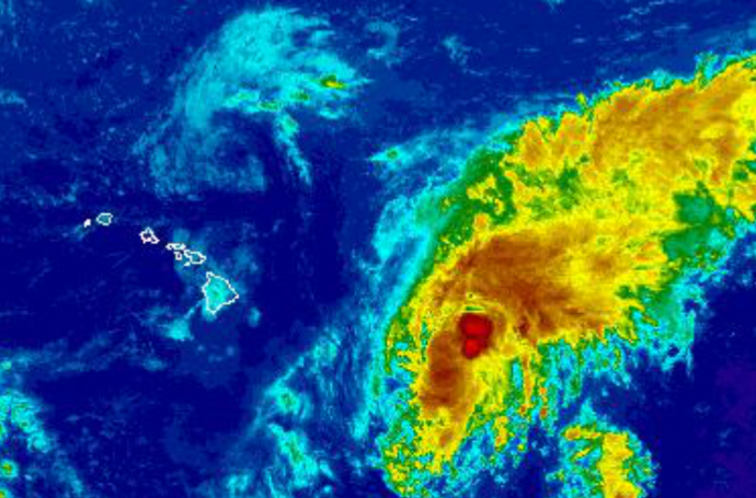
Image: NWS Satellite 3 p.m.
UPDATED WEATHER FORECAST: If the track holds true the forecast is calling for mostly cloudy skies and scattered windward showers on Tuesday with east winds around 15 mph for Maui County.
Wednesday and Thursday, the forecast becomes more uncertain, however on its current track Guillermo is expected to bring 20 to 30 mph winds out of the northeast to northwest with mostly cloudy skies, and heavy rain for windward spots. There’s a chance of heavy rain for leeward areas during the day with heavy rain likely at night. A slight chance of thunderstorms also exists Wednesday night and Thursday.
Friday and Saturday winds should be back out of the east from 15 to 20 mph with mostly cloudy skies and likely showers for windward spots, scattered showers for leeward areas.
Keep in mind, this is all subject to change with even little adjustments to the track and intensity of Guillermo as the system continues to approach the Hawaiian Islands.
Read more >>
State Civil Defense / Coast Guard Urging Residents to Continue Prep Despite Weakening Conditions
***Updated at 11:00 a.m. to include information from the Central Pacific Hurricane Center’s 11 a.m. update.***
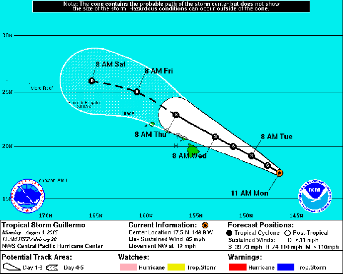
Image: NHC August 3, 2015 11 a.m. track
As of the Central Pacific Hurricane Center’s 11 a.m. update, Tropical Storm Guillermo was 670 miles ESE of Kahului, 720 miles ESE of Kaunakakai and 695 miles ESE of Lanai City. Maximum sustained winds are now at 65 mph with higher gusts. Guillermo is ragged in appearance and continues to weaken as forecasted. The system is now moving northwest at 12 mph. This motion is expected to continue through Wednesday.
The forecasted track has again been nudged slightly north. On this track, the center of Guillermo is forecast to pass approximately 150 miles northeast of the Big Island on Wednesday. Tropical storm force winds extend 140 miles from the center.
The CPHC says a watch may be issued later today or tonight. They refrained from issuing a watch during this update because of the northward shift and weaker winds.
*** Original post from 5:00 a.m. to include information from the Central Pacific Hurricane Center’s 5 a.m. update.***
[flashvideo file=http://www.youtube.com/watch?v=pFwnRoZTgoI /]
As forecasted, Guillermo continues its slow weakening trend, now a tropical storm with maximum sustained winds of 70 mph. The storm, located about 735 miles ESE of Kahului, 790 miles ESE of Kaunakakai and 765 miles ESE of Lanai City. Guillermo is looking more disorganized as it continues to move WNW at 10 mph.
The track forecast has been nudged slightly north since yesterday. Having said that, it’s important to focus on the entire forecast cone and not uniquely on the middle line of the track. Track error looking this far out into the future can still be hundreds of miles wide as evidenced by how vast the error cone gets that far out in time.
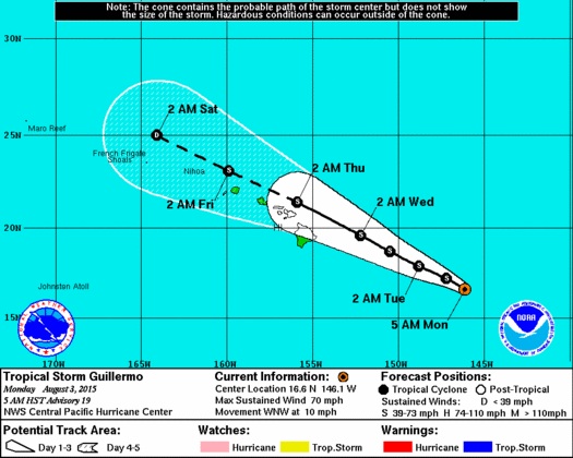
Image: NHC 5 a.m. track Monday 8/3/15
If this track remains true, Guillermo should reach our southeastern offshore waters by Tuesday at tropical storm strength, then approach the Big Island sometime Wednesday morning and track along the smaller islands on Wednesday and Thursday.
Guillermo is experiencing unfavorable conditions for further development. Vertical wind shear is starting to tear the system apart as it tracks north over cooler waters.
Tropical storm force winds now extend 125 miles from the center so it’s always good to remember that even if the center of the storm is not tracking right for the islands impacts can extend well away from the center.
In fact, although no watches or warnings are in effect at this time. We anticipate a tropical storm watch may be issued as early as this afternoon or evening depending on what happens today.

Image: NHC 5 a.m. update Monday 8/3/15
Having said that, impacts to the islands from Guillermo will start to show today. Large swells ahead of Tropical Storm Guillermo are expected to spread from east to west through the island chain. Big, dangerous surf is expected for east facing shores through about midweek. A High Surf Advisory is in effect and could be upgraded to a warning depending on conditions.
As far as weather effects, it’s still a little too early to talk about any specific wind conditions for the islands, but it is now very likely that the large field of moisture associated with Guillermo will bring periods of heavy rain and potential for significant flooding statewide from late Tuesday through Thursday.
Details of timing, exact location and amount of rainfall are still very uncertain and depend on where Guillermo actually ends up going and with what strength.
Sponsored Content


