

5 p.m. Update, Guillermo to Become Tropical Depression by Thursday Night
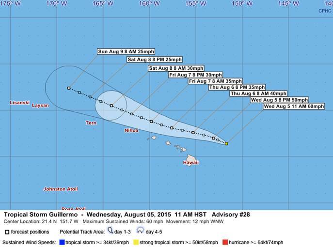
IMAGE: Maui County Civil Defense. 11 a.m. 8/5/15.
(Update: 5 p.m. 8/5/15)
*5 p.m. Update by Wendy Osher
Guillermo is weakening and is moving far enough north of the main Hawaiian islands to keep land areas beyond tropical storm force conditions, according to the Central Pacific Hurricane Center.
As of 5 p.m., the system was located 220 miles NE of Hilo and 270 miles E of Kahului, Maui.
Guillermo had maximum sustained winds of 50 mph and was moving WNW at 10 mph.
According to the latest forecast track, the center of the storm is expected to pass about 170 miles north of the Big Island and 125 miles north of Maui on Thursday; and about 100 miles north of Oʻahu and Kauaʻi on Thursday night and Friday.
The Central Pacific Hurricane Center is forecasting that Guillermo will transition from a tropical storm to a tropical depression by Thursday night.
Th National Weather Service says swells associated with Guillermo will continue to produce large, life-threatening surf along the East facing shores of the main Hawaiian Islands over the next couple of days. Because of the dangerous surf, state officials have closed Waiʻānapanapa State Park in East Maui.
(Update: 2 p.m. 8/5/15)
The Flash Flood Watch has been cancelled by the National Weather Service in Honolulu.
(Update: 11 a.m. 8/5/15)
*11 a.m. Update by Wendy Osher
A tropical storm watch was dropped at 11 a.m. on Wednesday for Maui and the Big Island of Hawaiʻi given a high confidence for continued weakening and a decrease in wind probabilities over the islands, forecasters with the Central Pacific Hurricane Center said.
At 11 a.m., Guillermo was located 245 miles ENE of Hilo, and 305 miles E of Kahului, Maui.
The system maintained maximum sustained winds of 60 mph and picked up its forward motion to 12 mph in the WNW direction.
The updated forecast track takes the system 160 miles NNE of the Big Island late tonight, 130 miles NNE of Maui on Thursday, and 100 miles N of Oʻahu and Kauaʻi Thursday night and Friday.
Th National Weather Service says swells associated with Guillermo will produce large, life-threatening surf along the East facing shores of the main Hawaiian Islands over the next couple of days. Because of the dangerous surf, state officials have closed Waiʻānapanapa State Park in East Maui.
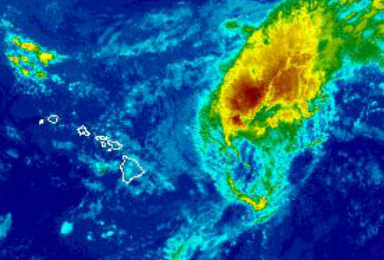
Image: NWS satellite 5 a.m. August 5, 2015
(Update: 5 a.m. 8/5/15)
By Meteorologist Malika Dudley
Quite a bit of moisture associated with Guillermo has now reached the islands since late last night, bringing more showers to the area. Latest radar imagery indicates there are heavier showers in this moisture field, while the rain gage at Kapahi recorded almost a third of an inch of rain in fifteen minutes. Latest satellite imagery showed more band of clouds associated with Guillermo are heading towards the islands today. Trade winds are expected across the state, bringing showers mostly to windward areas.
Guillermo continues to slowly weaken this morning with maximum sustained winds at 60 mph with higher gusts. The system is moving WNW at 9 mph, and is expected to continue on this path over the next couple of days, with another slight increase in forward speed, according to the Central Pacific Hurricane Center. The storm is now expected to weaken faster, becoming a tropical depression Thursday.
Guillermo is now expected to make a closer pass – about 90 miles NE of Maui on Thursday.

Image: CPHC 5 a.m. August 5, 2015
Tropical storm force winds extend outward up to 185 miles from the center, mainly to the north of the center, according to agency reports. The chance for tropical storm force winds is 3% in Hilo and 9% in Kahului, which has trended down slightly since the 2 a.m. forecast package.
The CPHC says tropical storm conditions are possible on the Big Island of Hawaiʻi and the islands within Maui County later today into Thursday. The current forecast calls for potential total rainfall amounts of 1-3 inches, with maximum amounts near 7 inches mainly in high terrain areas.
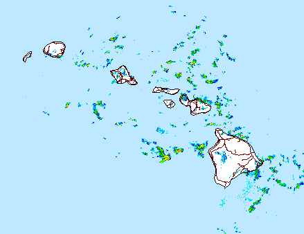
Image: NWS radar 5 a.m. August 5, 2015
On the water, forecasters say swells associated with Guillermo will produce large surf along east facing shores of the main Hawaiian Islands over the next couple of days.
Guillermo is now 335 miles E of Kahului, 390 miles E of Kaunakakai and 370 miles E of Lanai City. All islands in Maui County are still under a Tropical Storm Watch. A Flash Flood Watch and High Surf Warning have been issued for all of Maui County as well.
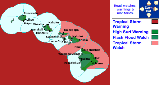
Image: NWS warnings and advisories 5 a.m. August 5, 2015
TROPICAL STORM WATCH
This watch is in effect for Maui County and the Big Island and windward waters / channels surrounding these islands. A tropical storm watch means that sustained winds of 34kt or higher are possible, in this case within the next 24 to 36 hours. Small craft should seek harbor. If you live on a boat, safely secure your craft and make plans to seek shelter on shore.
A tropical storm watch is issued when conditions are expected in the specified area of the watch within 48 hours. A watch is typically issued before the possible arrival of tropical storm force winds which make continuing outside preparations dangerous. This is the time for you to prepare.
FLASH FLOOD WATCH
The watch is posted through 6:00 p.m. Thursday for abundant moisture from tropical storm Guillermo moving over the area. Excessive runoff may produce rock and mudslides in steep terrain. Fast-moving water may create life-threatening situations.
A Flash Flood Watch means that conditions may develop that lead to flash flooding. Flash flooding is very dangerous. Remember that it does not have to be raining heavily where you are for flash flooding to occur.
HIGH SURF WARNING
A High Surf Warning has been issued through 6:00 a.m. Thursday for east-facing shores of Maui and Moloka’i. Wave heights of 10 to 15 foot faces are expected today and tonight. Expect ocean water occasionally sweeping across portions of beaches. Very strong breaking waves and strong longshore rip currents. Breaking waves may occasionally impact harbors making navigating the harbor channel dangerous.
(Update: 2 a.m. 8/5/15)
By Wendy Osher
At 2 a.m., Guillermo was located 290 miles E of Hilo and 375 miles E of Kahului, Maui. The system was moving toward the WNW near 8 mph, and is expected to continue on this path over the next couple of days, with a slight increase in forward speed, according to the Central Pacific Hurricane Center.
On the current forecast track, CPHC forecasters say the center of Guillermo is expected to pass about 175 miles NE of the Big Island of Hawaiʻi late Wednesday night, and 115 miles NE of Maui on Thursday.
Maximum sustained winds are near 60 mph with higher gusts. The agency states that steady weakening is forecast over the next couple of days. Tropical storm force winds extend outward up to 185 miles from the center, mainly to the north of the center, according to agency reports. The chance for tropical storm force winds is 6% in Hilo and 12% in Kahului, which has trended down slightly according to the CPHC.
The CPHC says tropical storm conditions are possible on the Big Island of Hawaiʻi and the islands within Maui County later today into Thursday. The current forecast calls for potential total rainfall amounts of 1-3 inches, with maximum amounts near 7 inches mainly in high terrain areas.
On the water, forecasters say swells associated with Guillermo will produce large surf along east facing shores of the main Hawaiian Islands over the next couple of days.
The Central Pacific Hurricane Center offers the following Preparedness Tips:
- It is vital that you do not focus on the exact forecast track. Forecast movement, direction, and speed are only estimates. Even small errors in the forecast track can mean major differences in where the worst conditions will occur. Damaging effects can extend far from the center.
- For those under a watch, now is the time to prepare. Secure or bring indoors any loose outdoor objects like lawn furniture, childrens toys, hanging plants, barbecue grills, or any item that could become a destructive projectile in strong winds. Do not wait until it is too late.
- Stay calm and keep informed. Closely monitor NOAA weather radio or other local news outlets for official storm information. Listen for warnings or changes to the forecast.
- Be ready to evacuate if necessary. Heed the advice of local officials and comply with any orders that are issued. Persons living near the shore should be prepared to evacuate quickly should building surf threaten.
- Loose objects such as lawn furniture, garbage cans, and other items should be secured or stored indoors. Have supplies on hand and be ready for power outages. Evacuate if ordered by local officials.
Sponsored Content


