


Ignacio/Jimena Update: 2:45 p.m. Monday, Aug. 31, 2015

Image: CPHC 5 a.m. track Ignacio 8/31/15
***Updated at 2:45 p.m. to include information from the National Weather Service and the Central Pacific Hurricane Center.***
By Wendy Osher
Maui Flood Advisory Until 5:15 p.m. 8/31/15
A Flood Advisory is in effect for Maui until 5:15 p.m. on Monday, Aug. 31, 2015.
The National Weather Service released a forecast saying radar at around 2:06 p.m. showed an area of nearly stationary heavy showers and thunderstorms just south and east of ʻUlupalakua.
The public is urged to stay away from streams, drainage ditches and low-lying areas that are prone to flooding. Motorists and pedestrians are reminded to avoid crossing fast flowing or rising water in their vehicle or on foot.
The advisory may need to be extended if heavy rains persist.
Ignacio Update:
Overnight, Ignacio was downgraded to a Category 2 hurricane. Officials with the Hawaiʻi Emergency Management Agency say there is less than 20% chance of tropical storm force winds impacting Hawaiʻi Island and Maui, and both islands have been lifted out of a Tropical Storm Watch.
“Breezy to gusty wind conditions are expected as Ignacio’s center passes by the state. There may also be heavy rainfall and isolated thunderstorms through Wednesday as a moist air mass lingers over the islands following Ignacio’s departure,” agency officials said.
High Surf Warnings also remain in effect for Hawaiʻi Island and Maui along east and southeast facing shores, with surf heights reaching 12 to 20 feet.
Jimena Update:
The Hawaiʻi Emergency Management Agency says Jimena remains an “extremely powerful Category 4 hurricane.” Forecasts show Jimena slowing down significantly as it reaches the central Pacific. Forecasters say it is expected to weaken to Category 1 status by Saturday.
__________________
***Updated at 5 a.m. to include information from the Central Pacific Hurricane Center.***
By Wendy Osher
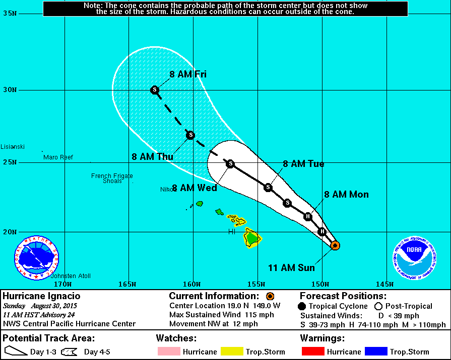
Hurricane Ignacio continues to steadily weaken as it approaches the Hawaiian Islands on a track that is expected to take it north east of the state.
Forecasters say the system could bring wet and humid weather to the state. Damaging winds, authorities say, are not expected, but the public is still encouraged to monitor additional updates.
The system was located 335 miles east of Hāna, Maui and was moving toward the NW at 10 mph at last report. Maximum sustained winds had dropped to 105 mph—making it a Category 2 hurricane.
Significant weakening is expected the next couple of days, with the rate of weakening expected to slow on Tuesday and Wednesday, according to the Central Pacific Hurricane Center.
Hurricane force winds extend outward up to 60 miles from the center, and tropical storm force winds extend outward up to 175 miles.
*Click here for today’s daily weather forecast.

Image: CPHC 11 p.m. track Ignacio 8/30/15
***Updated at 11:00 p.m. to include information from the Central Pacific Hurricane Center.***
By Meteorologist Malika Dudley
Hurricane Ignacio is still a major category three hurricane with winds at 115 mph. Rapid weakening is expected through Monday with a slower weakening trend through Tuesday.
Hurricane force winds extend 45 miles from the center, while tropical storm force winds extend up to 175 miles from the center of Ignacio.
The system is expected to pass east and northeast of Hawaii over the next couple of days and is currently moving northwest near 9 mph.
The CPHC says total rainfall amounts of 1 to 4 inches, with isolated amounts near 5 inches mainly in areas of higher terrain, are possible. Swells generated by Ignacio will increase along east and southeast facing shores of the Big Island and Maui County and will result in elevated surf heights through Tuesday. The high surf is expected to create dangerous currents. High winds are no longer expected.
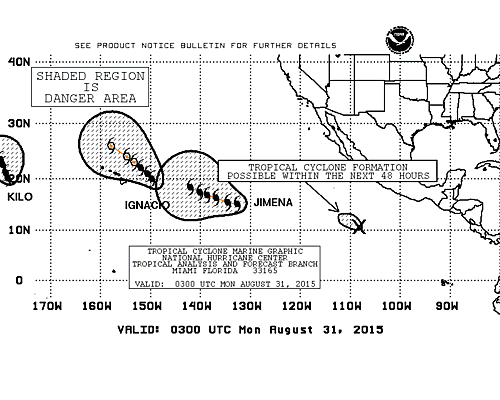
Image: NHC 11 p.m. track Jimena and Ignacio 8/30/15
Meanwhile, hurricane Jimena is moving west-northwest near 17 mph and expected to slow down over the next couple of days. Maximum sustained winds are near 150 mph making the system a category 4 hurricane. Only slow weakening is forecast over the next 48 hours. Hurricane force winds extend outward up to 60 miles, while tropical storm force winds extend up to 175 miles from the center.
***Updated at 5:00 p.m. to include information from the Central Pacific Hurricane Center.***
By: Jamilia Epping
The Tropical Storm Watch for the Big Island and Maui County has been dropped, as of the Central Pacific Hurricane Center’s 5 p.m. advisory.
Hurricane Ignacio was located 355 miles east of Hilo and moving to the northwest at 12 miles per hour. The storm is still classified as a Category 3 hurricane with maximum sustained winds of 115 mph.
CPHC forecasts that the biggest impact that Hurricane Ignacio will have on the island will be surf related. Large swells are still expected along east and southeast-facing shores.
A Tropical Storm Warning is still in effect for waters to the northeast of the Big Island.
Meanwhile, Hurricane Jimena was located 1,525 miles east of Hilo. Jimena is carrying maximum sustained winds at 150 mph, keeping it as a Category 4 hurricane.
The National Hurricane Center reports that as of 5 p.m., Hurricane Jimena is moving to the west-northwest at 16 mph.
Hurricane Jimena is soon expected to enter the Central Pacific. During that time, Jimena is forecast to gradually slow down and slowly weaken.
—————–
[flashvideo file=http://www.youtube.com/watch?v=Lc2xF_mUJqA /]
***3:30 p.m. Update 8/30/15***
Meteorologist Malika Dudley checked in with Warning Coordination Meteorologist Chris Brenchley at the Central Pacific Hurricane Center today.
Light to moderate trades are expected to continue tonight with showers favoring windward and mountain areas. Hurricane Ignacio is forecast to pass a couple of hundred miles to the northeast of us starting Monday. Periods of breezy and wetter weather are expected, especially towards the middle of the week when southerly flow is expected in the wake of Ignacio. Locally heavy rain is also possible during this time.
————-
11 a.m. Update, 8/30/15
By Wendy Osher
Hurricane Ignacio is now a Category 3 hurricane with maximum sustained winds near 115 mph. As of 11 a.m., Ignacio was moving toward the NW at 12 mph and was located: 400 miles E of Hilo; 470 miles ESE of Hāna; 500 miles ESE of Kahului; 540 miles ESE of Kaunakakai; and 530 miles ESE of Lānaʻi City.
Forecasters with the Central Pacific Hurricane Center say Ignacio will continue to approach the area from the southeast, bringing an increased potential for tropical storm conditions to the Big Island and Maui County. Agency officials say that due to the uncertainty in the exact track of Ignacio, it is still too early to determine which island is most at risk.
Based on the latest forecast, authorities say “there is little chance for hurricane conditions.” The chance for tropical storm conditions is now below 13%.
The latest forecast is for sustained winds to remain below tropical storm force of 39 mph, but NWS forecasters say, “only a small change in the track of Ignacio could result in higher winds.”
Swells generated by Ignacio will affect east and southeast facing shores of Maui, resulting in surf heights of 6 to 12 feet today, and reaching up to 15 to 20 feet on Monday through Tuesday.
The CPHC is forecasting the possibility of total rainfall amounts of 1 to 4 inches, with isolated amounts near 5 inches mainly in areas of higher terrain.
Ignacio 11 a.m. forecast track. Sunday, Aug. 30, 2015. Image credit: NOAA/NWS/CPHC
The NWS and Central Pacific Hurricane Center offered the following Preparedness Tips:
- It is vital that you do not focus on the exact forecast track. Forecast movement, direction, and speed are only estimates. Even small errors in the forecast track can mean major differences in where the worst conditions will occur. Damaging effects can extend far from the center.
- For those under a watch, now is the time to prepare. Secure or bring indoors any loose outdoor objects like lawn furniture, children’s toys, hanging plants, barbecue grills, or any item that could become a destructive projectile in strong winds. Do not wait until it is too late.
- Stay calm and keep informed. Closely monitor NOAA weather radio or other local news outlets for official storm information. Listen for warnings or changes to the forecast.
- Be ready to evacuate if necessary. Heed the advice of local officials and comply with any orders that are issued. Persons living near the shore should be prepared to evacuate quickly should building surf threaten.
- Loose objects such as lawn furniture, garbage cans, and other items should be secured or stored indoors. Have supplies on hand and be ready for power outages. Evacuate if ordered by local officials.
Sponsored Content


