

Slight Chance of Afternoon Thunderstorms Today
Image: Chris Archer
Alerts (as of 1:00 a.m.)
There are no weather alerts posted at this time.
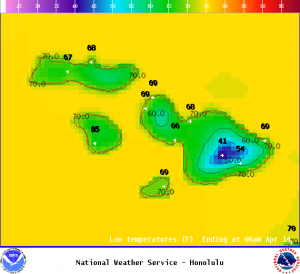
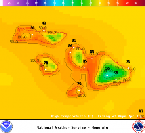
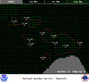
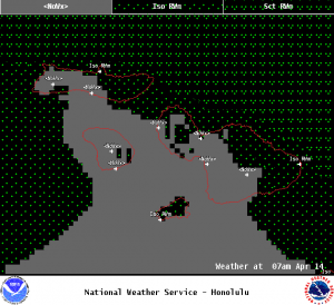
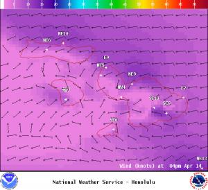
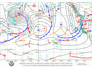
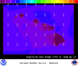
**Click directly on the images below to make them larger. Charts include: Maui County high/low forecasted temperatures, projected winds, projected localized weather conditions and expected wave heights.**
Looking Ahead
Our winds are expected to become light and variable Thursday night into Friday. This means our weather pattern will change allowing for a land and sea breeze pattern to take hold. Conditions are iffy with a disturbance nearby which could stir up some action in the form of heavy rain and a slight chance of thunderstorms. Meanwhile, showers will continue to focus over our usual windward and mauka spots through Thursday morning. By afternoon, we could see cloud cover building for leeward spots instead with a chance of rain and unstable conditions. Trade winds this weekend will bring us back to windward focused showers with strengthening trade winds from Sunday through Tuesday bringing an increase in windward showers.
Today
We have northeast winds today from 5 to 15 mph with afternoon sea breezes for leeward areas. High temperatures are forecast from 81° to 86°. Partly cloudy skies are forecast with scattered showers during the day. The leeward sides are forecast to be sunny to start with mostly cloudy skies in the afternoon and scattered showers. Locally heavy rainfall is possible with a slight chance of thunderstorms.
UV index at 10 (“very high” exposure level)
Tonight
Mostly cloudy skies with showers likely for windward areas and clearing skies for the leeward sides. Low temperatures from 68° to 73°. Winds are forecast out of the northeast from 5 to 15 mph with a land breeze developing.
Our Maui Now Weather homepage always includes daily: Sunrise | Sunset | Moonrise | Moonset | Moon Phase | Live Weather Cams | 5-day Forecast | Current Temperature & Conditions
***Click here for your marine outlook and surf report.***
Image; NOAA
Image; NOAA
Image; NOAA
Image; NOAA
Image; NOAA

Image; NOAA
Image; NOAA
Image; NOAA
Sponsored Content


