Pu‘u ‘Ō‘ō Eruption Approaching Many Anniversaries
The longest-lived and most voluminous rift-zone eruption of Kīlauea Volcano in more than 500 years—the ongoing Pu‘u ‘Ō‘ō eruption—began in January 1983, and is fast approaching its 35th anniversary.
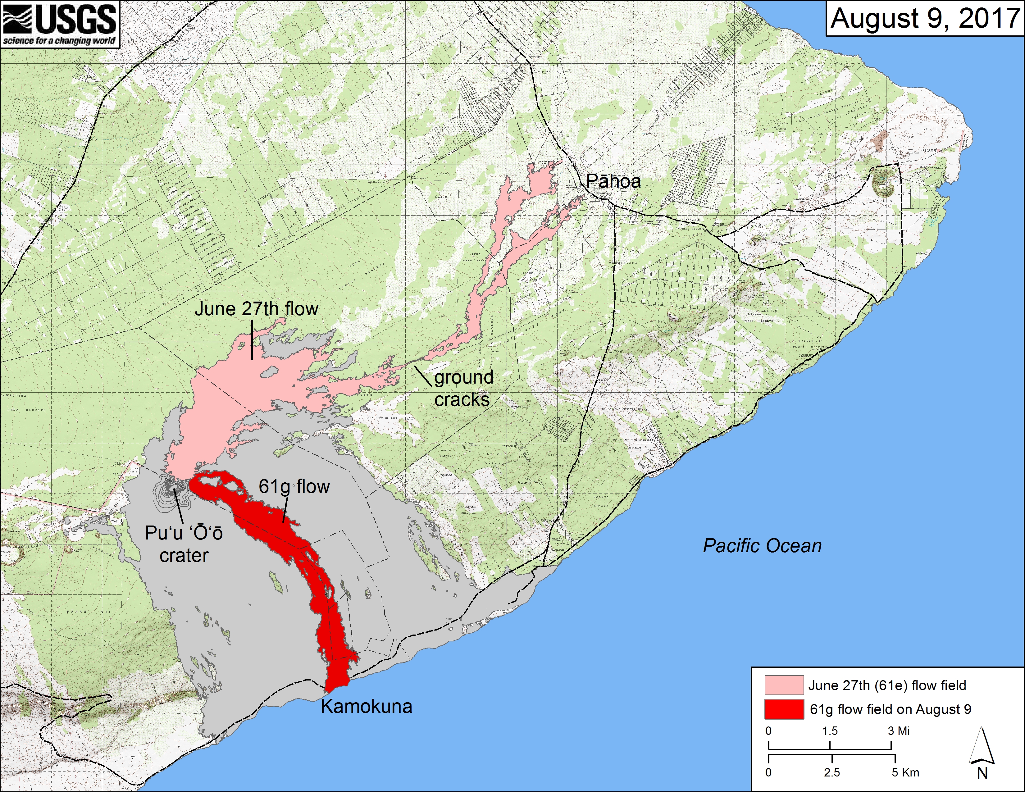
Map of lava flows erupted from Pu‘u ‘Ō‘ō since 1983. Gray color shows area covered by lava flows erupted from many different vents between 1983 and June 2014. Pink shows the area covered by the June 27th flow between June 2014 and June 2016. Red shows the area covered by the 61g flow between May 2016 and August 9, 2017. The vents that supplied lava to these flow fields are only 500 m (1/3 mile) apart. PC: USGS Hawaiian Volcano Observatory
So many lava flows, cones, deltas, and other features have formed from eruptions at different vents for varying periods of time that nearly every day is an anniversary for Pu‘u ‘Ō‘ō.
Last month marked the first anniversary of the 61g lava flow’s entry into the ocean at Kamokuna after traveling from Pu‘u ‘Ō‘ō nearly 6.8 miles in two months.
Three years ago this week, the infamous June 27th lava flow was erupting from Pu‘u ‘Ō‘ō and spreading steadily eastward about 330 ft per day. On Aug. 18, 2014, lava spilled into the first of several deep ground cracks along the East Rift Zone.
This set in motion intense scrutiny of the flow’s day-to-day advance by HVO scientists, and contingency planning among Hawai҆‘i County and State governments, businesses, and residents.
The crack system is located about 6.2 miles northeast of Pu‘u ‘Ō‘ō. At the time, it seemed possible, perhaps likely, that the June 27 lava would keep moving northeast toward several communities in the Puna District.
On Aug. 20, HVO scientists discussed the progression of the flow and possible scenarios with the Hawai‘i County Mayor and Civil Defense Administrator, and their staffs and other interested parties should the same active vent at Pu‘u ‘Ō‘ō continue erupting lava for weeks to months, or longer.
On Aug. 24, the first of 28 public meetings in Pāhoa and nearby communities was organized by the Mayor’s office to share information about the current eruption, status of the flow, possible scenarios based on HVO’s projected lava-flow paths, and the ways in which the County, State, and others were planning to mitigate the continued advance of the flow.
On Sept. 4, with lava advancing about 820 ft/day, HVO scientists estimated that the flow could reach Kaohe Homesteads subdivision within seven days—they raised the USGS Volcano Alert Level for Kīlauea Volcano from WATCH to WARNING.
These one- and three-year anniversaries of events during the Pu‘u ‘Ō‘ō eruption are but two that help us appreciate two very different outcomes based on the interplay of several factors. These include location of the vent, robustness of lava-tube systems that develop in lava flows, slope of the ground, longevity of an erupting vent, and the variability in lava discharge from the vent day-to-day and week-to-week.
The June 27th and 61g vents are located only about 1/3 mile from each other, but their associated lava flows spilled into different drainages that were constructed by earlier eruptions at Pu‘u ‘Ō‘ō. This resulted in the June 27th flow spreading northeastward on the north side of the rift zone about 13.7 miles, and the 61g flow spreading south of the rift zone to the ocean in only 6.8 miles.
The 61g flow has erupted for 15 months thus far, with most of the lava flowing through the tube system and entering the ocean. The June 27th lava flow was active for 23 months, but the tube system was not able to supply most of the lava to the active flow fronts for the entire time. Why not?
The inconsistent lava discharge from the June 27th vent and the longer than 10 mile tube system on gentle ground both combined to interrupt or reduce, and eventually cut off lava supply to the flow fronts, thereby limiting the ultimate length of the flow. After the first four months, the flow fronts stalled at a distance of about 13.7 miles from Pu‘u ‘Ō‘ō, less than 0.6 miles from Highway 130. After 9 months, in March 2015, the active parts of the flow retreated to less than 5 miles from the vent, much to the relief of Puna residents.
Volcano Activity Updates
This past week, Kīlauea Volcano’s summit lava lake level varied 92-144 ft below the vent rim, with fluctuations in concert with summit inflation and deflation. On the East Rift Zone, the 61g flow remained active, with lava entering the ocean near Kamokuna and surface breakouts downslope of Pu‘u ‘Ō‘ō. The 61g flows do not pose an immediate threat to nearby communities.
Mauna Loa is not erupting. During the past week, small-magnitude earthquakes continued to occur beneath the volcano, primarily in the upper Southwest Rift Zone, at depths less than 3 miles. GPS measurements continue to show deformation related to inflation of a magma reservoir beneath the summit and upper Southwest Rift Zone. No significant changes in volcanic gas emissions were measured.
One earthquake with three or more felt reports in the Hawaiian islands occurred during the past week. On Aug. 16, at 5:24 a.m. HST, a magnitude-3.1 earthquake located 6.2 miles ENE of Honoka’a and 9 miles deep.
Sponsored Content