

New Fissure, 22nd Vent Located SE of Puna Geothermal
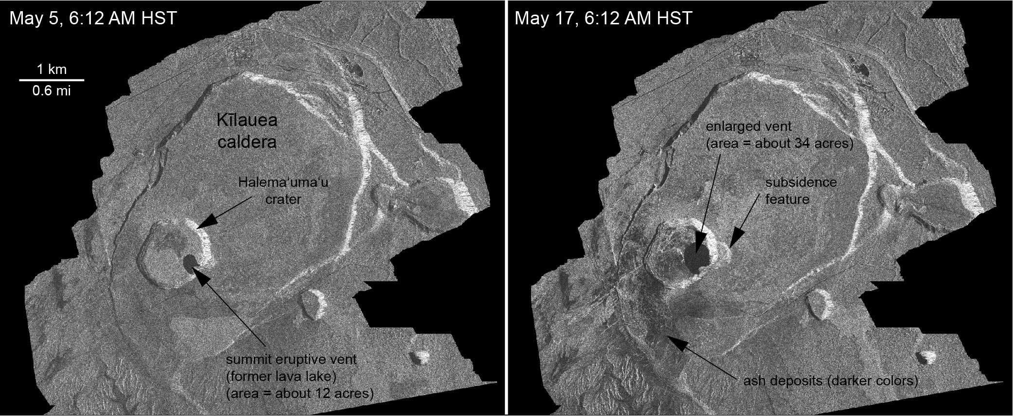
These radar amplitude images were acquired by the Italian Space Agency’s Cosmo-SkyMed satellite system and show changes to the caldera area of Kīlauea Volcano that occurred between May 5 at 6:12 a.m. HST (left) and May 17 at 6:12 a.m. HST (right). The satellite transmits a radar signal at the surface and measures the strength of the reflection, with bright areas indicating a strong reflection and dark areas a weak reflection. Strong reflections indicate rough surfaces or slopes that point back at the radar, while weak reflections come from smooth surfaces or slopes angled away from the radar. The May 17 image was acquired after two small explosions from the summit eruptive vent. Major changes with respect to the May 5 image include: (1) a darkening of the terrain south of Halema‘uma‘u, which may reflect accumulation of ash over the 12-day period between the images; (2) enlargement of the summit eruptive vent on the floor of Halema‘uma‘u, from about 12 acres on May 5 to about 34 acres on May 17; and (3) the development of a small depression (area of about 15 acres) on the east rim of Halema‘uma‘u that reflects slumping of a portion of the rim towards the growing collapse pit on the crater floor. PC: US Geological Survey
(Update: 6 a.m. 5.18.18)
The Hawaiian Volcano Observatory has reported a new fissure this morning, between fissures 19 and 20, in an area southeast of the Puna Geothermal Venture facility.
The latest development comes as the eruption enters its third week.
Forty structures have been reported destroyed as of this morning.
Several fissures are active with spattering. A lava flow at fissure 17 is covering the existing lava flow, but no new advancement is occurring.
Due to the continued volcanic activity the following policies are in effect:
- Do continue to be on the alert for volcanic fumes of SO2.
- Volcanic gas such as SO2, is especially dangerous for elderly, children/babies and people with respiratory problems.
- People in areas downwind of rifts may intermittently experience higher levels of fumes. People with breathing problems should avoid being outdoors and leave the area if deemed necessary.
To help residents, authorities are distributing free masks for ash protection.
- Distribution will continue today from 1 p.m. to 7 p.m. at Cooper Center and Ocean View Community Center.
- One mask per family member.
- Masks DO NOT protect against gasses and vapors. They will only provide filtering for ash.
A third shelter has opened. Sure Foundation, located on Pōhaku Circle in Keaʻau, is now open.
- People from Pāhoa who have breathing concerns are relocating from the Pāhoa Community Center shelter to the Sure Foundation shelter.
- The shelter will cater specifically to people with breathing issues, but everyone is welcome.
- All shelters are pet friendly.
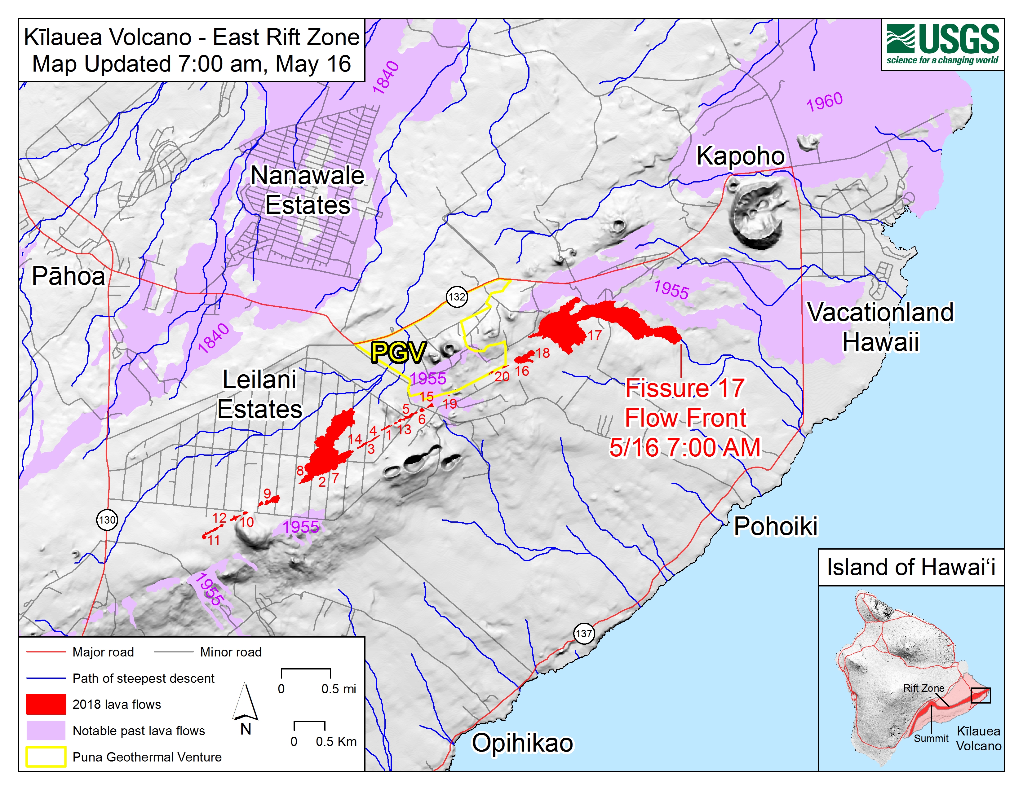
Map shows the location of the lava flow spreading from fissure 17 as of 7:00 a.m. HST, May 16. The flow is following a path of steepest descent (blue line) south of a 1955 ‘a’ā flow. Shaded purple areas indicate lava flows erupted in 1840, 1955, 1960, and 2014-2015. PC: US Geological Survey.
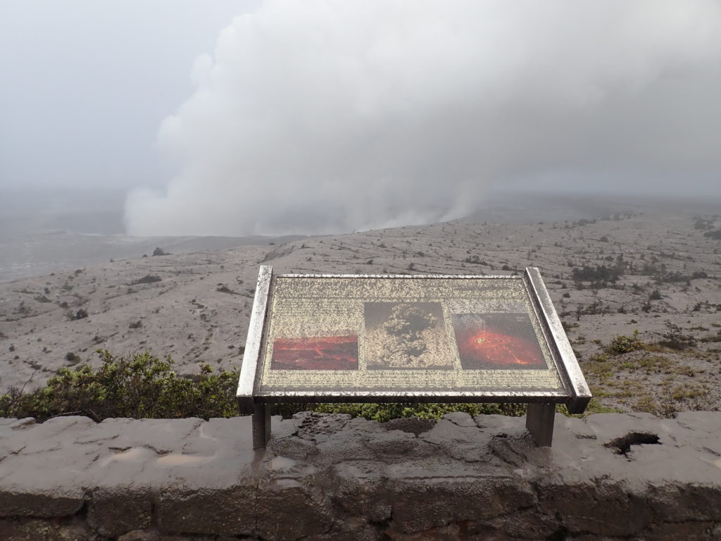
At 7:45 a.m. HST on Thursday, May 17,, view of Halema‘uma‘u crater from the visitor viewing area in front of the Jaggar Muesum, Hawai‘i Volcanoes National Park. A light coating of ash on the Park’s interpretative sign resulted from ash falling to the ground from explosive events of the past day. Note the contrast of the plume rising from the Overlook vent this morning (background) with the eruption column that erupted during explosive activity in May 1924 (middle photograph on sign). PC: US Geological Survey.
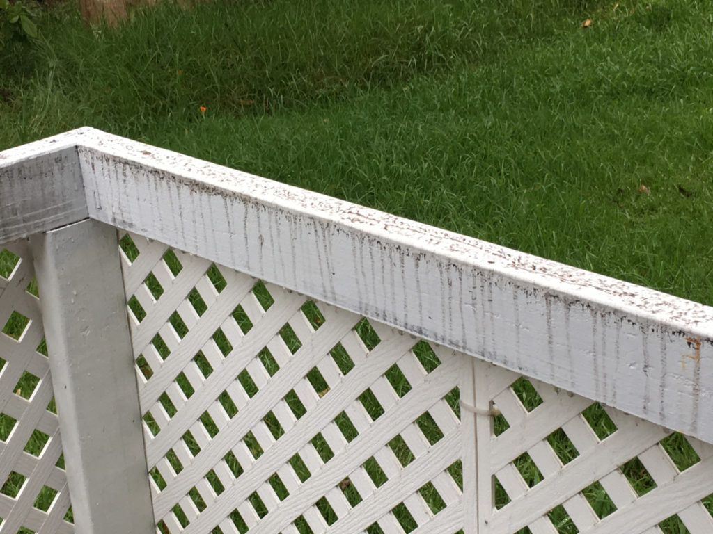
At 7:45 a.m. HST, only traces of ash (dark areas on white rail) remain on this fence in the Volcano Golf and Country Club Subdivsion, located 4 km (2.5 mi) from the Overlook crater in Hawai‘i Volcanoes National Park. PC: US Geological Survey
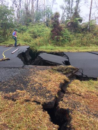
HVO geologist next to cracks on Nohea Street in Leilani Estates on Thursday morning. These cracks expanded significantly in the past day. Note the vertical offset across the cracks. PC: Thursday, May 17, 2018, US Geological Survey.
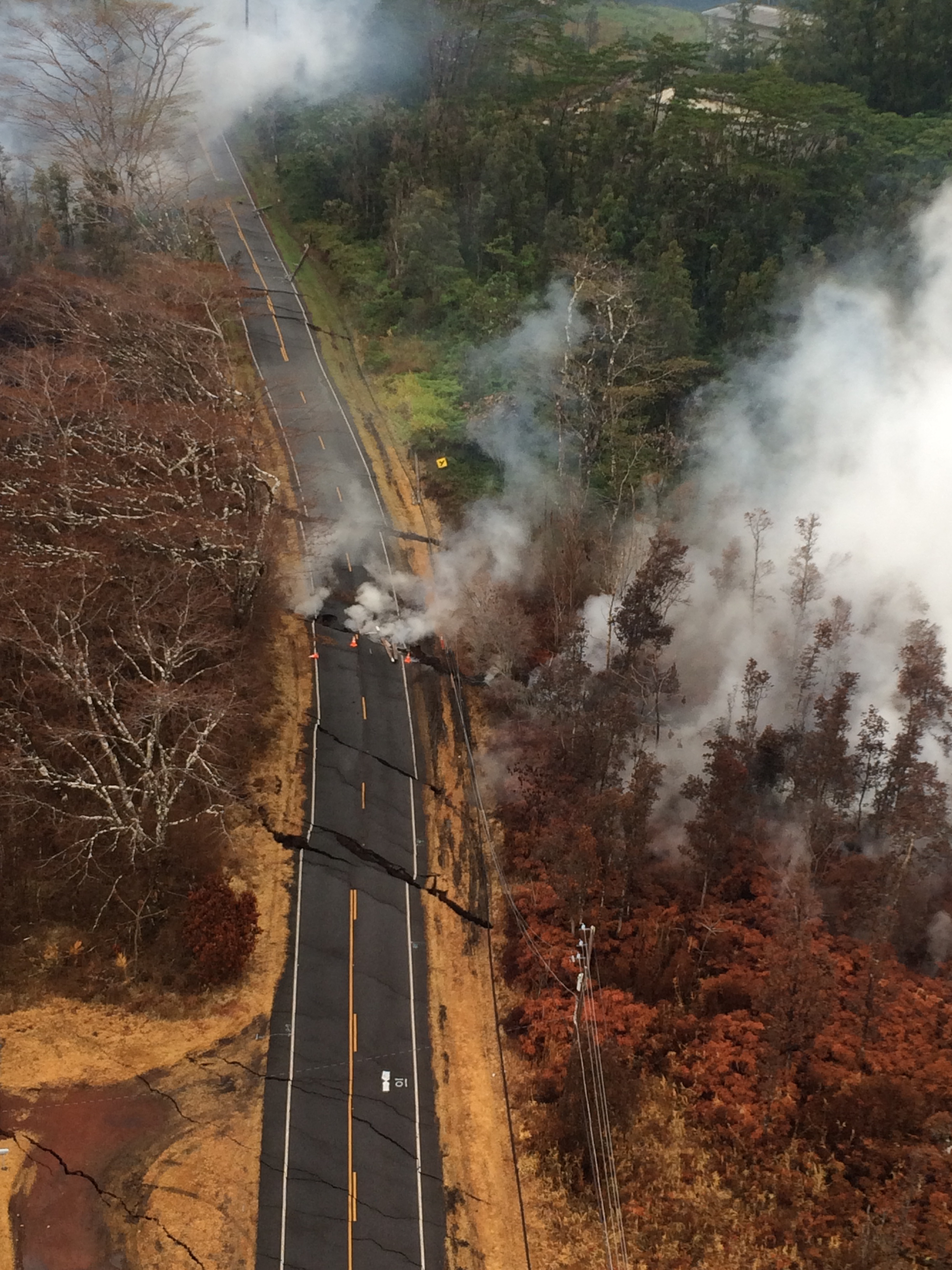
Aerial view of ground cracks on Pohoiki Road during an overflight of the eruptive fissure area at about 7 a.m. HST on Thursday, May 17, 2018. Cracks continued to open and widen, some with horizontal and vertical offsets, in the area during the past 24 hours. These cracks are caused by the underlying intrusion of magma into the lower East Rift Zone. PC: US Geological Survey.
Sponsored Content


