

Olivia Maintains Intensity as Category 1 Hurricane
****Below is a LIVE Facebook video update from Maui Now Meteorologist, Malika Dudley at 6:34 p.m. HST on Sunday, Sept. 9, 2018.
https://www.facebook.com/mauinow/videos/2278134212258617/
UPDATE: 5 p.m. HST, Sunday, Sept. 9, 2018
The National Weather Service has ISSUED a TROPICAL STORM WATCH for MAUI COUNTY, as well as Oʻahu and Hawaii County ahead of Olivia as it continues on a path towards the Hawaiian Islands. A Tropical Storm Watch means that tropical storm conditions are possible within the watch area within 48 hours.
At 5 p.m. HST on Sunday, Sept. 9, 2018, the center of Hurricane Olivia was located 595 miles ENE of Hilo; 655 miles E of Kailua-Kona; 650 miles ENE of South Point; 640 miles E of Hāna; 670 miles E of Kahului; 705 miles E of Kaunakakai; 700 miles E of Lānaʻi City; and 760 miles E of Honolulu (near latitude 21.7 North, longitude 146.1 West).
Olivia’s forward motion had slowed yet again and was last moving West at around 12 mph, a motion that is forecast to continue for the next 12 to 24 hours with some slowing forward speed.
The CPHC says a WSW motion is expected to begin later Monday and Olivia will approach the main Hawaiian Islands later Tuesday and Tuesday night.
The system has maintained its Category 1 intensity with maximum sustained winds are near 75 mph and higher gusts. The CPHC says little change in strength is forecast during the next 36 hours, with gradual weakening expected afterward.
Hurricane-force winds extend outward up to 25 miles from the center and tropical-storm-force winds extend outward up to 125 miles.
Potential impacts include wind impacting the watch area starting Tuesday; total rainfall amounts of 10-15 inches with isolated amounts over 20 inches over affected areas; and large swells along exposed East facing shores Tuesday or Wednesday.
LOCAL AREA FORECASTS: (Click here for a drop down menu of your local area forecast)
WEST MAUI: (Lahaina, Olowalu and Nāpili) Local area forecasts show the potential for peak winds in the 45-55 mph range with gusts to 80 mph possible in West Maui. The window for Tropical Storm force winds is Tuesday evening until early Thursday morning. The peak rainfall amounts for West Maui are 3-6 inches, with locally higher amounts.
WINDWARD WEST MAUI (Including Wailuku) Peak Wind Forecast: 45-55 mph with gusts to 80 mph. Window for Tropical Storm force winds: Tuesday evening until early Thursday morning. Peak Rainfall Amounts: Additional 6-10 inches, with locally higher amounts. Potential for major flooding rain.
CENTRAL VALLEY: (Kahului, Puʻunēnē and Māʻalaea) Local area forecasts show the potential for peak winds in the 45-55 mph with gusts to 80 mph possible in Central Maui. The window for Tropical Storm force winds is Tuesday evening until early Thursday morning. The latest local forecast as of 5 p.m. shows peak rainfall amounts of 1-3 inches, with locally higher amounts for Central Maui.
WINDWARD HALEAKALA: (Haʻikū, Hāna and Kīpahulu) The Peak Wind Forecast for east Maui calls for 45-60 mph with gusts to 90 mph. The window for Tropical Storm force winds is Tuesday afternoon until early Thursday morning. Peak Rainfall Amounts for this area is an additional 6-10 inches, with locally higher amounts.
LEEWARD HALEAKALA: (Kīhei and Mākena) Peak Wind Forecast: 45-60 mph with gusts to 90 mph. Window for Tropical Storm force winds: Tuesday afternoon until early Thursday morning. Peak Rainfall Amounts: Additional 4-8 inches, with locally higher amounts.
According to the latest forecast discussion, “Olivia has continued to exhibit an indistinct but persistent eye feature over the past several hours.”
The CPHC discussion also notes, “All of the intensity guidance depicts weakening after 36 hours, but at somewhat different rates.”
Forecasters with the CPHC advise the public: “It is important to not focus on the exact forecast track and intensity when planning for Olivia. Persons on all the main Hawaiian Islands should continue preparing for the likelihood of direct impacts from this system this week. Those impacts could include intense flooding rainfall, damaging winds, large and dangerous surf, and storm surge. Regardless of the exact track and intensity that Olivia takes as it approaches the islands, significant effects often extend far from the center. In particular, the mountainous terrain of Hawaiʻi can produce localized areas of strongly enhanced winds and rainfall, even well away from the tropical cyclone center.”
PREVIOUS POST:
UPDATE: 11 a.m. HST, Sunday, Sept. 9, 2018
Olivia remains at the lower edge of a Category 1 (74-95 mph) hurricane, with maximum sustained winds of 75 mph, but forecasters say the system is expected to remain a hurricane through Monday night.
The latest track could bring the outer circulation of Olivia close to the Hawaiian Islands starting on Tuesday night, according to the Central Pacific Hurricane Center.
The Central Pacific Hurricane Center says Tropical Storm or Hurricane Watches may be required for portions of the main Hawaiian Islands later today or tonight.
At 11 a.m. HST on Sunday, Sept. 9, 2018, the center of Hurricane Olivia was located 655 miles E of Hilo; 720 miles E of Kailua-Kona; 715 miles ENE of South Point; 705 miles E of Hana; 735 miles E of Kahului; 765 miles E of Kaunakakai; 765 miles E of Lanai City; 825 miles E of Honolulu (near latitude 21.7 North, longitude 145.1 West).
Olivia’s forward movement toward the west had slowed in the latest forecast to near 14 mph and this motion is expected to continue for the next 24 hours or so with some slowing in forward speed.
A WSW motion is expected to begin Monday night or Tuesday. Forecasters with the Central Pacific Hurricane Center say Olivia will be approaching the main Hawaiian Islands later Tuesday and Tuesday night.
Maximum sustained winds are near 75 mph with higher gusts. Little change in strength is forecast during the next 36 hours, with gradual weakening expected afterward, according to the CPHC.
The CPHC says hurricane-force winds extend outward up to 30 miles from the center and tropical-storm-force winds extend outward up to 125 miles.
On the water, large swells generated by Olivia are expected to reach the main Hawaiian Islands starting Monday, affecting exposed east facing shores into Tuesday or Wednesday.
The US Air Force Reserves 53rd Weather Reconnaissance Squadron will be conducting missions in and around Olivia later today. The mission is expected to help forecasters determine the track, intensity, and size of the system.
According to the latest forecast discussion issued by the CPHC, “Olivia is slowly moving toward warmer, though still marginal, sea surface temperatures and is in an environment of weak shear. This is expected to maintain intensity through the next 36 hours, perhaps with additional fluctuations. Shear is expected to start increasing over the tropical cyclone in 36 to 48 hours as an upper level trough north of the main Hawaiian Islands builds south. This should start to impart a weakening trend, which will be gradual at first, then more rapid in the days 3-5 period.”
The agency advises the public of the following: “It is important to not focus on the exact forecast track and intensity when planning for Olivia. Persons on all the main Hawaiian Islands should continue to monitor the progress of Olivia, and use this time to prepare for the increasing likelihood of direct impacts from this system this week. Regardless of the exact track and intensity that Olivia takes as it approaches the islands, significant effects often extend far from the center. In particular, the mountainous terrain of Hawaiʻi can produce localized areas of strongly enhanced winds and rainfall, even well away from the tropical cyclone center.”
Tropical Storm – winds 39-73 mph (34-63 kt)
Category 1 – winds 74-95 mph (64-82 kt)
Category 2 – winds 96-110 mph (83-95 kt)
Category 3 – winds 111-129 mph (96-112 kt)
Category 4 – winds 130-156 mph (113-136 kt)
Category 5 – winds 157 mph and up (137+ kt)
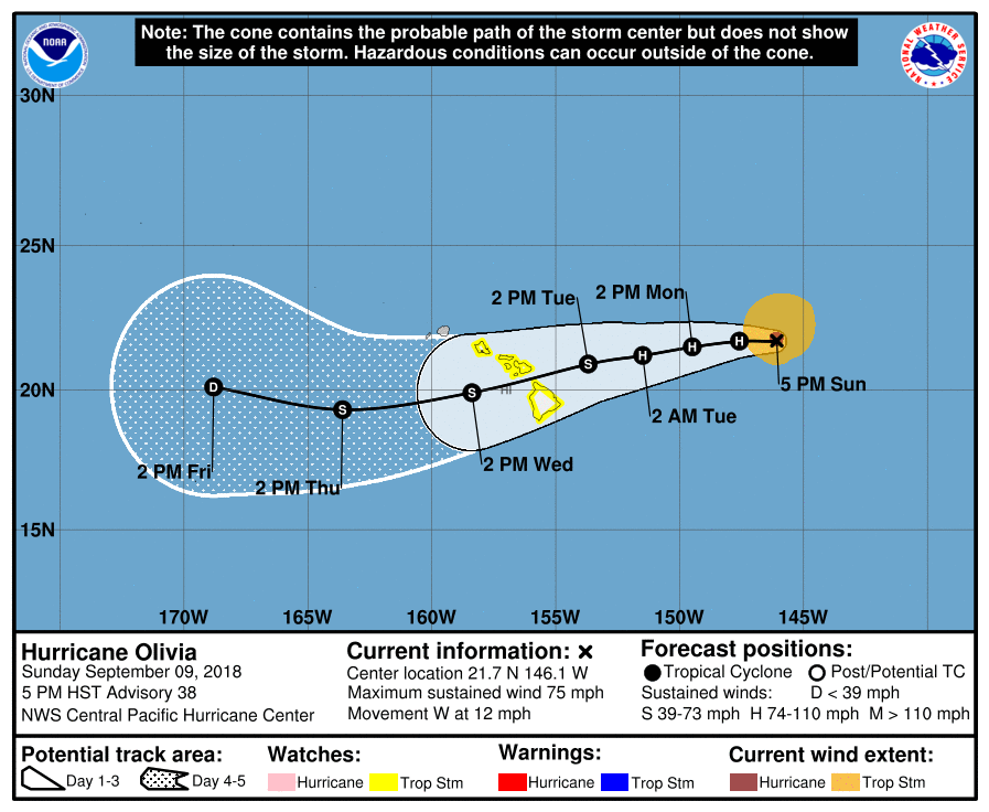
Olivia 5-day cone of uncertainty. PC: (9.9.18, 5 p.m. HST) NOAA/CPHC

Olivia satellite imagery. PC: (9.9.18, 5 p.m. HST) NOAA/CPHC

Olivia satellite imagery. PC: (9.9.18, 5 p.m. HST) NOAA/CPHC

Olivia satellite imagery. PC: (9.9.18, 5 p.m. HST) NOAA/CPHC

Olivia most likely arrival time of tropical storm force winds. PC: (9.9.18, 5 p.m. HST) NOAA/CPHC

Olivia earliest arrival time of tropical storm force winds. PC: (9.9.18, 5 p.m. HST) NOAA/CPHC
Sponsored Content


