


Volcano Watch – What does the Volcano Alert Level and Activation Color Code mean?

by US Geological Survey Hawaiian Volcano Observatory scientists and affiliates. Today’s article was written by Hawaiian Volcano Observatory geologist Natalia Deligne.
The US Geological Survey Hawaiian Volcano Observatory sets the Volcano Alert Level and Aviation Color Code for volcanoes in Hawaiʻi and American Samoa. Currently, Kīlauea is erupting and is at WATCH/ORANGE, Mauna Loa is in elevated unrest and is at ADVISORY/YELLOW, and the remaining six monitored volcanoes are at NORMAL/GREEN.
What do these designations mean, how does HVO assign them, and how can you find out if there is a change?
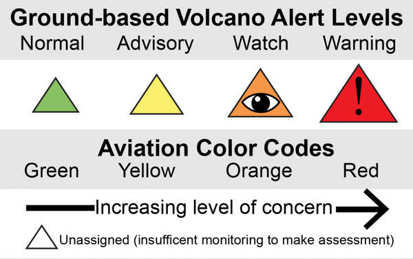
The first of the two-word designation is the Volcano Alert Level, which reflects the danger the volcano poses to people on the ground and infrastructure (“life and property”). USGS Volcano Alert Levels were established in 2006 and the four terms (NORMAL, ADVISORY, WATCH, WARNING) were chosen to mirror those used at the time by NOAA’s National Weather Service for severe storms and floods.
NORMAL indicates a non-eruptive background state of activity, ADVISORY reflects an activity level elevated above background, WATCH is used when an eruption is likely, or an eruption is occurring with limited hazards, and WARNING means a hazardous eruption is imminent, underway, or suspected.
What does the color mean? The Aviation Color Code is designed specifically for the aviation sector. It was originally developed by the Alaska Volcano Observatory in the 1990s to rapidly communicate to pilots, dispatchers, and air traffic controllers the threats posed to aviation by restless or erupting volcanoes. In the early 2000s, the International Civil Aviation Organization adopted the system, and the Aviation Color Code is now a recommended practice for all volcano observatories around the world.
The Aviation Color Code approach is similar to the Volcano Alert Level (the Aviation Color Code inspired the Volcano Alert Level) but is specifically for the aviation sector. GREEN and YELLOW have the same definition as NORMAL and ADVISORY, while ORANGE (eruption likely or an eruption is occurring with no/minor ash) and RED (eruption with significant ash emission is imminent, underway, or suspected) are focused on whether there is a threat to aviation posed by volcanic ash.
To determine the appropriate Volcano Alert Level and Aviation Color Code, HVO monitors volcanic activity around the clock with seismometers, cameras, satellites, and other instruments that can detect signs of magma moving underground or lava and ash actively erupting.
Knowing exactly when to change the Volcano Alert Level and Aviation Color Code can be challenging. We do not have set thresholds: each situation is different. We decide by looking at all monitoring data, previous unrest and eruption patterns, and what is known about the processes occurring at the volcano. Typically, there is extended discussion among HVO scientists before a change is made. Sometimes the designation is unchanged for many years, although occasionally, frequent changes are warranted.
Kīlauea’s current status is WATCH/ORANGE. The ongoing eruption is confined within Halemaʻumaʻu crater—posing no threat to life or property—and the eruption has no to minor volcanic ash emission.
Mauna Loa’s current status is ADVISORY/YELLOW. This reflects elevated rates of earthquakes and ground deformation above background. This activity indicates that magma is being supplied to Mauna Loa’s magma chamber, but at this stage magma is not moving beneath the ground to erupt on the surface. If signs of magma on its way to erupt appear, or if Mauna Loa returns to background levels of activity, HVO will change Mauna Loa’s Volcano Alert Level and Aviation Color Code accordingly.
Volcano Alert Level changes are announced in a USGS Volcanic Activity Notification, which explains why the change was made and what is likely to happen next based on the current scientific consensus (Aviation Color Code changes are also announced in a Volcano Observatory Notice for Aviation).
In summary, the Volcano Alert Level and Aviation Color Code communicates the degree and, in some cases, the time frame of a particular volcanic threat for people on the ground and in the aviation sector. With this information, public safety and emergency managers, individuals and families, and businesses can take appropriate and timely steps to keep our communities safe.
Volcano Activity Updates
Kīlauea volcano is erupting. Its USGS Volcano Alert level is at WATCH.
Over the past week, lava has continued to erupt from the western vent within Halemaʻumaʻu crater in Hawai‘i Volcanoes National Park. Sulfur dioxide emission rates remain elevated and were last measured at approximately 350 tonnes per day (t/d) on November 22. Seismicity is elevated but stable, with few earthquakes and ongoing volcanic tremor. Over the past week, summit tiltmeters recorded two deflation-inflation (DI) events.
Mauna Loa is not erupting and remains at Volcano Alert Level ADVISORY. This alert level does not mean that an eruption is imminent or that progression to an eruption from the current level of unrest is certain.
This past week, about 144 small-magnitude earthquakes were recorded below the summit and upper elevation flanks of Mauna Loa—the majority of these occurred at shallow depths less than 15 kilometers (9 miles) below sea level. Global Positioning System (GPS) measurements show continued ground deformation consistent with inflation of a magma chamber beneath the summit. Gas concentrations and fumarole temperatures at both the summit and at Sulphur Cone on the Southwest Rift Zone have remained stable over the past week. Webcams show no changes to the landscape.
There were 5 events with 3 or more felt reports in the Hawaiian Islands during the past week: a M3.6 earthquake 12 km (7 mi) ESE of Pāhala at 29 km (18 mi) depth on Nov. 20 at 5:07 p.m. HST, a M2.8 earthquake 5 km (3 mi) E of Waimea at 14 km (9 mi) depth on Nov. 18 at 3:45 p.m. HST, a M3.5 earthquake 6 km (3 mi) SSW of Pāhala at 32 km (20 mi) depth on Nov. 17 at 3:07 p.m. HST, a M3.0 earthquake 26 km (16 mi) E of Honaunau-Napoopoo at 0 km (0 mi) depth on Nov. 17 at 7:22 a.m. HST, a M3.9 earthquake 5 km (3 mi) SSW of Pāhala at 31 km (19 mi) depth on Nov. 16 at 6:56 p.m. HST.
HVO continues to closely monitor Kīlauea’s ongoing eruption and Mauna Loa for any signs of increased activity.
Volcano Watch is a weekly article and activity update written by US Geological Survey Hawaiian Volcano Observatory scientists and affiliates.
Sponsored Content


