


Calvin on swift path west, winds still 50 mph; Storm impacts “imminent” for Hawaiʻi Island
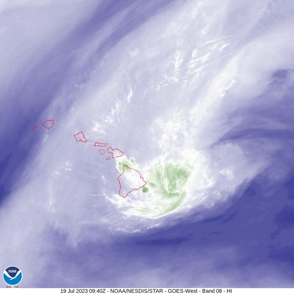
 Hawaiʻi satellite imagery as Tropical Storm Calvin moves to the west. 12 a.m. 7.19.23) PC: NOAA/NWS
- Hawaiʻi IR satellite imagery as Tropical Storm Calvin moves to the west. 12 a.m. 7.19.23) PC: NOAA/NWS
- Hawaiʻi water vapor satellite imagery as Tropical Storm Calvin moves to the west. 12 a.m. 7.19.23) PC: NOAA/NWS
- Enhanced radar imagery of of Hawaiʻi as Tropical Storm Calvin moves to the west. (12 a.m. 7.19.23) PC: NOAA/NWS


A new post was created to house Calvin Updates for Wednesday. Link HERE.
Calvin begins pass south of Big Island; impacts to Hawaiʻi County are imminent or occurring
11 p.m. update:
The latest forecast update from the Central Pacific Hurricane Center notes that while the center of Tropical Storm Calvin is passing south of the Big Island, most of the island “is well within” the radius for impacts from strong winds, heavy rainfall, and high surf, which are “imminent or occurring.”
As of 11 p.m., Tropical Storm Calvin was located 140 miles south of Hilo, Hawaiʻi; 90 miles SSE of South Point, Hawaiʻi; 215 miles SSE of Hāna, Maui; 235 miles SSE of Kahului, Maui; 260 miles SSE of Kaunakakai, Molokaʻi; 240 miles SSE of Lānaʻi City, Lānaʻi; and 305 miles SE of Honolulu, Oʻahu.
Calvin’s intensity weakened slightly in the latest forecast period to 50 mph maximum sustained winds and minimum central pressure of 29.62 inches, according to the Central Pacific Hurricane Center. Tropical-storm-force winds continue to extend outward up to 140 miles from the center.
Forward motion also dipped slightly to 20 mph from 21 mph in the last report.
According to the Central Pacific Hurricane Center’s Forecast Discussion, “Deep convection has decreased considerably near the center of Calvin since late this afternoon, but has begun to increase farther to the north along windward shores and slopes of the Big Island of Hawaiʻi. The low level circulation center is rapidly becoming unveiled again.”
The National Weather Service says the “most damaging wind and weather conditions” are currently focused over the Big Island and the islands in Maui County tonight through Wednesday. The NWS says each island will see about a 12-18 hour period of weather impacts.
MAUI SPECIFIC IMPACTS: According to an NWS Forecast Discussion, the island of Maui can expect the following:
“Strong easterly winds with deepening unstable tropical moisture will produce periods of heavy rain over the islands in Maui County, especially over the windward mountain slopes. Rainfall totals of 3 to 6 inches with isolated higher amounts will be possible tonight through Wednesday. A Flood Watch remains in effect through Wednesday. Damaging winds will also develop with the strongest winds downwind of terrain or leeward areas. Wind gusts of over 60 mph will be possible and a High Wind Warning remains in effect this evening with peak winds expected late tonight through Wednesday morning. Winds this strong will be capable of knocking down trees and causing power outages, so please limit travel if possible.”
A High Wind Warning is in effect until 6 p.m. Wednesday for Maui County. The NWS forecast says the strongest winds will likely occur in areas over and downwind of terrain.
On the water, a High Surf Warning remains in effect for east facing shores of the Big Island, Maui, Molokaʻi, and Kahoʻolawe tonight through Wednesday due to rapidly building surf generated by Calvin. The warning calls for “dangerously large and disorganized waves of 15-20 feet along affected shorelines.
The NWS reports that warning and advisory level surf heights will be “short-lived” and will likely occur late tonight into Wednesday morning for the Hawaiʻi Island, and through the afternoon Wednesday for the smaller islands.
The forecast calls for an increase in vertical shear through Wednesday night, which the CPHC says should result in weakening of the system to a post-tropical/remnant low by Friday.
- Hawaiʻi satellite imagery as Tropical Storm Calvin moves to the west. 3 p.m. 7.18.23) PC: NOAA/NWS
- Hawaiʻi IR satellite imagery as Tropical Storm Calvin moves to the west. 8 p.m. 7.18.23) PC: NOAA/NWS
- Radar imagery of of Hawaiʻi as Tropical Storm Calvin moves to the west. (8 p.m. 7.18.23) PC: NOAA/NWS


Calvin approaching Big Island; Impacts in Hawaiʻi County are imminent
8 p.m. update:
As of 8 p.m., Calvin is located about 150 miles SSE of Hilo, Hawaiʻi, and 350 miles SE of Honolulu, Oʻahu. The Central Pacific Hurricane Center reports that a Tropical Storm Warning remains in effect for Hawaiʻi Island where storm impacts are imminent.
Tropical Storm Calvin continues on a westward path at 21 mph. Maximum sustained winds remain at 60 mph, and higher gusts, and tropical-storm-force winds extend outward 140 miles from the center, according to the National Weather Service.
A Flood Advisory was issued for portions of the Big Island until 11:15 p.m. At 8:05 p.m. the National Weather Service reported that radar was showing heavy rain over east sections of the Big Island. Heavy rain was falling at a rate of 1 to 2 inches per hour in some areas and “increasing in coverage as Tropical Storm Calvin approaches from the east.”
MAUI SPECIFIC INFO: For Maui County, the National Weather Service reports that “very strong easterly winds with ample tropical moisture will produce periods of heavy rain over the windward areas and especially over the windward mountains.” The NWS is forecasting rainfall totals of 3 to 6 inches with isolated higher amounts possible tonight through Wednesday.
A Flood Watch will be in effect starting tonight through Wednesday for Maui County. “Aside from the heavy rain threat, damaging winds will be possible with the strongest winds downwind of terrain or leeward areas.” The NWS continues to forecast possible wind gusts of over 60 mph.
Peak winds on Maui are expected late tonight through Wednesday morning, according the NWS. Forecasters are urging the public to prepare according saying, “Winds this strong will be capable of knocking down trees and causing power outages.”
On the water, a High Surf Warning remains in effect for east facing shores of the Big Island, Maui, Molokaʻi, and Kahoʻolawe tonight through Wednesday. “Peak surf heights will be short-lived and will likely occur late tonight into Wednesday morning,” according to the National Weather Service. The NWS warning notes that “dangerously large and disorganized” waves of 15-20 feet are expected along exposed east facing shores.
- Hawaiʻi satellite imagery as Tropical Storm Calvin moves to the west. 3 p.m. 7.18.23) PC: NOAA/NWS
- Five day forecast. (5 p.m. 7.18.23) PC: NOAA/NWS/CPHC
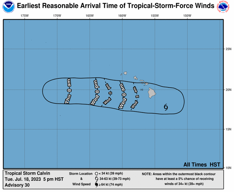
- Earliest Reasonable Arrival Time of Tropical-Storm-Force Winds. Calvin (5 p.m. 7.18.23) PC: NOAA/NWS/CPHC


Calvin 175 miles from Big Island; Impacts in Hawaiʻi County forecast to start tonight
5 p.m. update:
Tropical Storm Calvin is now 175 miles SE of Hilo, Hawaiʻi, and is moving toward the west at 21 mph. The Central Pacific Hurricane Center continues to report that the start of impacts is forecast to begin tonight on Hawaiʻi Island, which remains under a Tropical Storm Warning.
Maximum sustained winds are near 60 mph with higher gusts, with tropical-storm-force winds extending outward up to 140 miles from the center, according to the CPHC.
The National Weather Service reports the center of Tropical Storm Calvin is forecast to pass nearby just south of the Big Island of Hawaiʻi tonight and early Wednesday, then pass “well south” of the other Hawaiian Islands through Wednesday night.
Currently, Calvin is located 270 miles SE of Hāna, Maui; 295 miles SE of Kahului, Maui; 330 miles SE of Kaunakakai, Molokaʻi; 315 miles SE of Lānaʻi City, Lānaʻi; and 390 miles SE of Honolulu, Oʻahu.
“Impacts are expected to be greatest on the Big Island, but strong winds, locally heavy rainfall and high surf along east facing shores can be expected statewide,” the NWS reports.
Calvin is expected to remain a tropical storm over the next 36 hours, and then will weaken quickly afterward.
MAUI SPECIFIC INFORMATION: Potential impacts for Maui include possible storm total rainfall of 3-6 inches tonight through Wednesday, surf of up to 15′ along East facing shores, and strong winds. The National Weather Service says damaging winds will be possible with “the strongest winds downwind of terrain or leeward areas.” According to the latest forecast from the National Weather Service, “Wind gusts of over 60 mph will be possible and a High Wind Warning remain in effect starting this evening with peak winds expected late tonight through Wednesday morning.”
The CPHC and NWS forecasts call for the following conditions:
- WIND: Tropical storm conditions are expected within the warning area starting this evening. Preparations for tropical storm force wind impacts should already be completed for persons in Hawaiʻi County. The National Weather Service reports: “Locally strong winds will begin this evening over the Big Island, with north winds shifting to the northeast and east as Calvin moves westward through Wednesday morning. Winds will primarily be northeasterly over the smaller islands, strongest Wednesday and Wednesday evening. It is important to note that the mountainous terrain of the islands can produce localized areas of enhanced winds, even well away from the tropical cyclone center.”
- RAINFALL: “Storm total rainfall amounts through Thursday are forecasted to be 4-8 inches, with maximum amounts of 10 inches possible, mainly along the windward slopes and southeast flank of the Big Island of Hawaiʻi. Storm total rainfall amounts of 3-6 inches are expected on the windward areas of Maui, and 2-4 inches elsewhere in the state. This rainfall could lead to localized flash flooding and mudslides,” according to the CPHC.
- SURF: Swells generated by Calvin are expected to begin spreading across the main Hawaiian Islands tonight. This will lead to a rapid increase in surf along east facing shores, with high surf continuing into Wednesday. According to the National Weather Service, surf may reach as high as 20 feet along east facing shores of the Big Island, up to 15 feet along east facing shores of Maui, and up to 12 feet along east facing shores of the other islands. “Although peak surf heights on the Big Island will likely occur around low tide Wednesday morning, some minor overwash and erosion is possible for exposed low-lying coastal areas. Smaller islands will peak later in the day Wednesday,” according to the NWS.
The National Weather Service issued a High Surf Warning for the east facing shores of the Big Island, Maui, Molokaʻi and Kahoʻolawe through Wednesday.
“Tropical Storm Calvin will rapidly generate warning level surf tonight into Wednesday morning for exposed east facing shores of the Big Island and most of Maui County, then quickly subside through the rest of Wednesday as Calvin moves further west away from the Big Island. Surf will build tonight into early Wednesday morning for east facing shores of Kauaʻi and Oʻahu, generating advisory level surf through Wednesday before lowering into Thursday morning,” according to the NWS.
- Hawaiʻi satellite imagery as Tropical Storm Calvin moves to the west. 3 p.m. 7.18.23) PC: NOAA/NWS
- Radar imagery of of Hawaiʻi as Tropical Storm Calvin moves to the west. (3 p.m. 7.18.23) PC: NOAA/NWS
- Five day forecast. (2 p.m. 7.18.23) PC: NOAA/NWS/CPHC


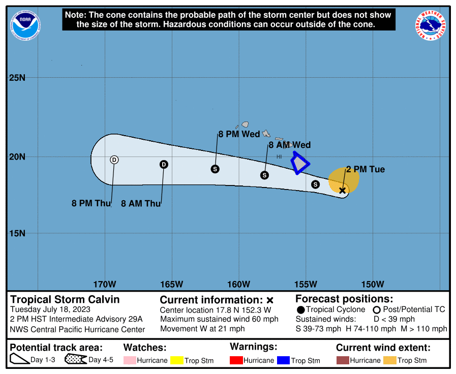


Calvin strengthens further with 60 mph sustained winds on approach to Hawaiʻi
2 p.m. update:
Tropical Storm Clavin strengthened further and now has sustained winds of 60 mph with higher gusts, according to a 2 p.m. update issued by the Central Pacific Hurricane Center. Tropical-storm-force winds now extend outward up to 140 miles from the center, forecasters said.
The National Weather Service states the “latest forecast has the center of Calvin passing just south of the Big Island tonight, which puts the Big Island under the front right quadrant, which is area that typical see’s the greatest rainfall.” According to the NWS, the greatest rainfall will likely occur over north and south Hilo, Puna and Kaʻū districts.
The NWS reports that damaging tropical storm force winds with wind gusts of over 60 mph will also be an issue with “the greatest wind accelerations expected over areas over and downwind of terrain such as the saddles and the Kohala districts” on Hawaiʻi Island.
As of 2 p.m., Calvin was 220 miles SE of Hilo; 315 miles SE of Hāna, Maui; 345 miles SE of Kahului, Maui; 380 miles SE of Kaunakakai, Molokaiʻi; 365 miles SE of Lānaʻi City, Lānaʻi; and 440 miles SE of Honolulu, Oʻahu.
Forward movement continues toward the west at a slightly decreased, but still swift speed of 21 mph, according to the CPHC forecast update.
A Tropical Storm Warning remains in effect for Hawaiʻi County.
“On the forecast track, tropical storm conditions will likely begin spreading over Hawaiʻi County starting this evening. Calvin is expected to remain a tropical storm over the next 36 hours, and then will weaken quickly afterward,” according to the CPHC update.
MAUI INFO: In the latest forecast update for Maui County, the NWS reported an increase in rainfall totals over windward Maui. “Rainfall totals of 3 to 6 inches with isolated higher amounts will be possible tonight through Wednesday… Aside from the heavy rain threat, damaging winds will be possible with the strongest winds downwind of terrain or leeward areas. Wind gusts of 60 mph will be possible, thus a High Wind Warning has been issued starting this evening with peak winds expected late tonight through Wednesday morning.”
The CPHC forecast calls for the following conditions:
WIND: Tropical storm conditions are expected within the warning area starting this evening. “Individuals in Hawaiʻi County should complete preparations for tropical storm force wind impacts during daylight hours prior to the onset of tropical storm conditions,” the CPHC advises.
RAIN: “From later today into Thursday, storm total rainfall amounts of 4-8 inches, with maximum amounts of 10 inches are possible, mainly along the windward and southeast flank of the Big Island of Hawaiʻi. Storm total rainfall amounts of 3-6 inches are expected on the windward areas of Maui, and 2-4 inches elsewhere in the state. This rainfall could lead to localized flash flooding and mudslides,” according to the CPHC.
SURF: The CPHC reports that swells generated by Calvin are expected to begin spreading across the main Hawaiian Islands later today and tonight. This will lead to a rapid increase in surf along east facing shores, with high surf continuing into Wednesday.

Calvin slightly stronger
11 a.m. update:
The Central Pacific Hurricane Center says Tropical Storm Calvin is slightly stronger this morning, and impacts for Hawaiʻi County are expected to start tonight.
As of 11 a.m, the system was about 245 miles ESE of Hilo; 335 miles SE of Hāna, Maui; 365 miles SE of Kahului, Maui; 405 miles SE of Kaunakakai, Molokaiʻi; 390 miles ESE of Lānaʻi City, Lānaʻi; and 465 miles ESE of Honolulu, Oʻahu.
Maximum sustained winds are now 50 mph with stronger gusts, and tropical-storm-force winds extending outward up to 115 miles from the center, according to the CPHC.
Calvin continues on a path west at 22 mph.
A Tropical Storm Warning is in effect for Hawaiʻi County; and a Flood Watch is in effect for the entire state from Tuesday night through Wednesday afternoon. A High Wind Warning was issued for Haleakalā on Maui from 6 p.m. tonight to 6 p.m. on Wednesday.
“On the forecast track, tropical storm conditions will likely begin spreading over Hawaiʻi County starting this evening… Calvin is expected to remain a tropical storm over the next 36 hours, and then will weaken quickly afterward,” according to the latest CPHC Forecast Discussion.
The CPHC forecast calls for the following conditions:
WIND: Tropical storm conditions are expected within the warning area starting this evening. The CPHC urges individuals in Hawaiʻi County to complete preparations for tropical storm force wind impacts during daylight hours prior to the onset of tropical storm conditions. The Maui Emergency Management Agency reports: east winds of 35 to 60 mph with localized gusts over 75 mph are expected at Haleakalā on Maui.
RAINFALL: “From later today into Thursday, storm total rainfall amounts of 4-8 inches, with maximum amounts of 10 inches are possible, mainly along the windward and southeast flank of the Big Island of Hawaiʻi. Storm total rainfall amounts of 3-6 inches are expected on the windward areas of Maui, and 2-4 inches elsewhere in the state. This rainfall could lead to localized flash flooding and mudslides,” according to the CPHC.
SURF: “Swells generated by Calvin are expected to begin spreading across the main Hawaiian Islands later today and tonight. This will lead to a rapid increase in surf along east facing shores, with high surf continuing into Wednesday,” the CPHC advises. ” Surf may reach as high as 15
feet along east facing shores of the Big Island, and up to 10 feet along east facing shores of the other islands. Although peak surf heights on the Big Island will likely occur around low tide Wednesday morning, some minor overwash and erosion is possible for exposed low-lying coastal areas,” according to the National Weather Service.

Calvin 335 miles ESE of Hilo
8 a.m. Update:
A Flood Watch remains in effect for Maui and Hawaiʻi Counties starting this evening. From tonight through Thursday, Maui could see total rainfall amounts of 2-6 inches from the North Shore near Haʻikū to East Maui near Hāna; while the big island (which is currently under a Tropical Storm Warning) is forecast to get 6-10 inches, according to the National Weather Service.
As of 8 a.m, ,Tropical Storm Clavin was located 335 miles ESE of Hilo, Hawaiʻi; and 420 miles ESE of Hāna, Maui. Maximum sustained winds are 45 mph with higher gusts.
Forecasters are urging residents to be prepared now for impacts starting this evening, including high surf, damaging winds and potential flooding.
- Satellite imagery of the Central and Eastern Pacific as Tropical Storm Calvin moves to the west. (5 a.m. 7.18.23) PC: NOAA/NWS
- Radar imagery of of Hawaiʻi as Tropical Storm Calvin moves to the west. (5 a.m. 7.18.23) PC: NOAA/NWS
- Five day forecast. (5 a.m. 7.18.23) PC: NOAA/NWS/CPHC
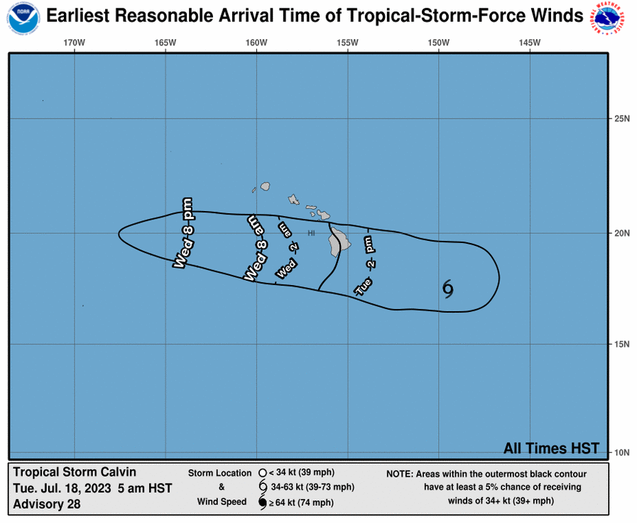
- Earliest Reasonable Arrival Time of Tropical-Storm-Force Winds. Calvin (5 a.m. 7.18.23) PC: NOAA/NWS/CPHC
- Calvin wind speed probabilities (2 a.m. 7.18.23) PC: NOAA/NWS/CPHC


Calvin “taking aim” at Hawaiʻi Island
5 a.m. Full Forecast
A Flash Flood Watch continues for Maui County and Hawaiʻi Island as excessive rainfall remains a possibility, according to the Maui Emergency Management Agency. A Tropical Storm Warning also remains in effect for Hawaiʻi County with conditions expected within the next 12-24 hours.
The Central Pacific Hurricane Center reports that Tropical Storm Calvin is “taking aim” at Hawaiʻi Island, with impacts starting this evening.
“On this forecast track, tropical storm conditions will likely begin spreading over Hawaiʻi County starting this evening. Deep convection has been developing near Calvin early this morning, which may slow the weakening trend today,” but gradual weakening is forecast from tonight through Thursday, according to the latest update from the Central Pacific Hurricane Center.
As of 5 a.m., the system was about 395 miles ESE of Hilo, Hawaiʻi; 480 miles ESE of Hāna, Maui; 510 miles ESE of Kahului, Maui; 550 miles ESE of Kaunakakai, Molokaʻi; 535 miles ESE of Lānaʻi City, Lānaʻi; and 610 miles ESE of Honolulu, Oʻahu.
The Central Pacific Hurricane Center reports an aircraft from the 53rd Weather Reconnaissance Squadron “Hurricane Hunters” completed sampling wind intensity from Calvin a few hours ago. Calvin has maximum sustained winds of 45 mph with higher gusts, and tropical-storm-force winds that extend outward from the center up to 105 miles.
The system continues on a westward path at swift 22 mph pace.
The National Weather Service say “damaging wind speeds are possible across most of the state as Calvin approaches and passes by each island.” According to the NWS, “Heavy showers and flooding conditions are expected due to deep unstable tropical moisture forced up the windward mountain slopes of islands in Maui and Hawaiʻi Counties.”
The CPHC forecast calls for the following conditions:
WIND: Tropical storm conditions are expected within the warning area starting Tuesday evening. “Individuals in Hawaiʻi County should complete preparations for tropical storm force wind impacts during daylight hours prior to the onset of tropical storm conditions tonight,” according to the CPHC. On Maui, a Wind Advisory is in effect through tonight, and a Wind Watch through Wednesday afternoon.
RAINFALL: From later today into Thursday, storm total rainfall amounts of 4-8 inches, with maximum amounts of 10 inches are possible, mainly along the windward areas of the Big Island of Hawaiʻi, according to the CPHC. Storm total rainfall amounts of 1-4 inches are expected elsewhere in Hawaiʻi, bringing the possibility of localized flash flooding and mudslides.
The National Weather Service reports that “highest potential for heavy rain and flooding” are expected along the windward slopes of the Big Island and windward slopes of the eastern half of Maui. The NWS forecast calls for the possibility of 2-6 inches in parts of Maui of storm total rainfall from the North Shore near Haʻikū to East Maui near Hāna.
SURF: Swells generated by Calvin are expected to begin spreading across the main Hawaiian Islands later today and tonight. This will lead to a rapid increase in surf along east facing shores, with high surf continuing into Wednesday, according to the CPHC. A High Surf Warning is in effect with dangerously large and disorganized waves of 10 to 15 feet in the forecast for Kahoʻolawe, Maui Windward West, Molokaʻi Windward, Molokaʻi Southeast, Windward Haleakalā, Kīpahulu and South Haleakalā.
The National Weather Service expects Calvin to weaken into a Tropical Depression by Wednesday and maintain its westward track, moving away from the island chain by Wednesday night. “Expect improving weather and wind conditions statewide by Thursday as we transition back to breezy trade wind pattern,” the NWS advises.

Sponsored Content


