Volcano Watch: What’s shaking beneath Mauna Loa?

“Volcano Watch” is a weekly article and activity update written by US Geological Survey Hawaiian Volcano Observatory scientists and affiliates.
It’s hard to believe that nearly one year has passed since Mauna Loa erupted. Mauna Loa has been mostly quiet since the end of the 2022 eruption, but a small increase in seismic activity in late October 2023 reminds us that the volcano remains active.
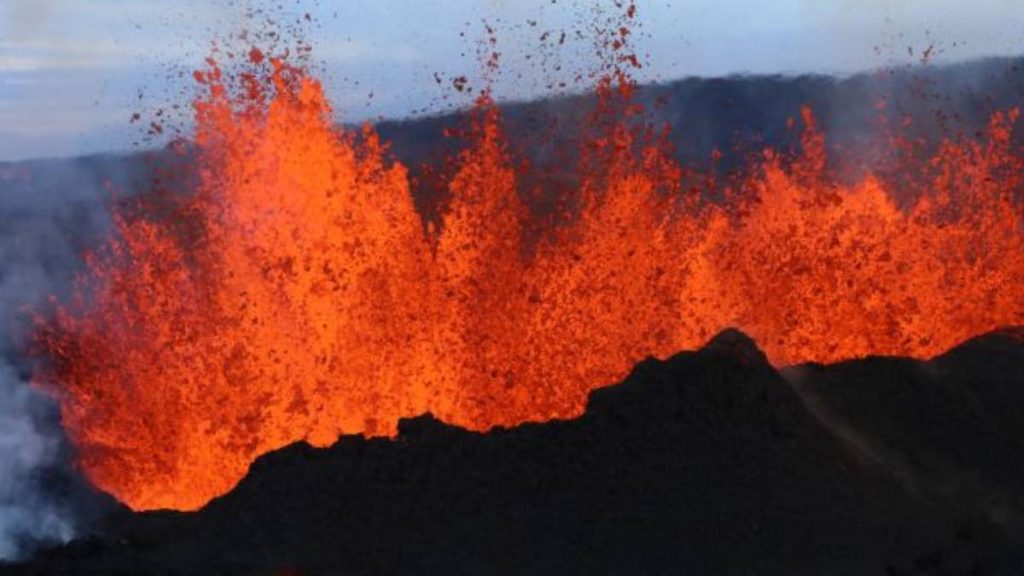
The 2022 event was significant in that it occurred following the longest noneruptive period — 38 years — at Mauna Loa in the past two centuries. Like most Mauna Loa eruptions, the 2022 eruption started in Mokuʻāweoweo (the summit caldera). Within hours, activity moved into the Northeast Rift Zone, generating lava flows primarily in a north/northeast direction that crept to within 3 km (2 mi) of the Daniel K. Inouye Highway, also known as Saddle Road.
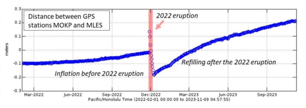
Following the 2022 eruption, which began Nov. 27 and ended Dec. 10, Mauna Loa quickly began to reinflate, indicating that magma continued to be supplied to the volcano’s magma chamber.
This observation is not unprecedented, as ground deformation rates on Mauna Loa were similarly high following the 1975 and 1984 eruptions, but eventually declined to background levels before the next volcanic unrest. In the months following the 2022 eruption, the deformation rates have slowly declined, though they remain relatively high.

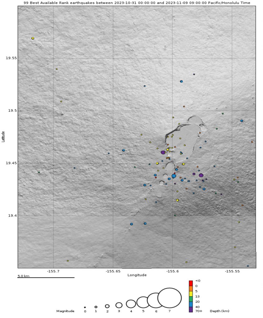
New seismic observations during the past month include more frequent occurrences of signals associated with magma movement. Most of these signals have occurred at depths of 40 to 60 km (25 to 37 mi) beneath Mokuʻāweoweo, though some have occurred at shallower depths within 16 km (10 mi) of the ground surface. These observations are also not unprecedented: similar signals at deep depths occurred during 2002 and 2004.
In the decades prior to the 2022 eruption, Mauna Loa exhibited several periods of prolonged and increasing unrest.
During the past week, the number of seismic events has decreased, but the rate of ground deformation remains high. If Mauna Loa seismic activity becomes more persistent — in combination with elevated rates of ground deformation — this might herald a shift back into a period of unrest.
Mauna Loa’s most recent eruptions in 2022, 1984, 1975 and 1950 occurred years to decades apart. However, prior to 1950, Mauna Loa erupted more frequently. Only three Mauna Loa eruptions occurred in the second half of the 20th century, but 12 eruptions happened in the first half of the century.
Mauna Loa eruptions have varied in duration. The 1949 summit eruption, for example, lasted nearly five months; this was soon followed by the 1950 Southwest Rift Zone eruption that lasted several weeks, generating lava flows that swiftly descended steep slopes in South Kona to enter the ocean within a few hours of the eruption onset.

Considering the past eruption patterns and current monitoring observations, is Mauna Loa entering another prolonged period of variable unrest like it had in the decades preceding the 2022 eruption? Alternatively, is the volcano entering a phase of more frequent eruptions like it had prior to 1950?
While the recent observations on Mauna Loa are not alarming, they are certainly thought-provoking.
Contextualizing these observations relative to past eruptions is difficult because the unrest and subsequent run-up to the most recent eruption were monitored with a denser and more modern equipment network compared to those previous. In the months prior to the 2022 eruption, U.S. Geological Survey Hawaiian Volcano Observatory staff were comparing earthquake activity to paper records from 1984, as well as comparing the tilt and GPS readings to relatively sparse ground deformation surveys from the years following the 1975 and 1984 eruptions.
Although Mauna Loa’s volcano alert level and aviation color code have remained at normal/green since the eruption ended last year, the volcano remains active and will erupt again in the future. The Hawaiian Volcano Observatory will continue to keep a close eye on Mauna Loa’s monitoring data, watching for additional signs that might indicate the volcano is entering a period of elevated unrest.
Volcano Activity Updates
Kīlauea is not erupting. Its volcano alert level is at advisory.
Southwest of Kīlauea’s summit, unrest associated with an intrusion that began in early October has diminished during the past week, though a small cluster of earthquakes has persisted near the middle Southwest Rift Zone. Seismicity and ground deformation might continue to wax and wane with changes in the rate of magma input to the area, and eruptive activity could occur in the near future with little or no warning. The most recent sulfur dioxide (SO2) emission rate for the summit — approximately 100 tonnes per day — was measured Oct. 19.
Mauna Loa is not erupting. Its volcano alert level is at normal.
Webcams show no signs of activity on Mauna Loa. Summit seismicity has increased slightly in the past month, while ground deformation indicates slow inflation as magma replenishes the reservoir system following the 2022 eruption. These processes are described in greater detail above. SO2 emission rates are at background levels.
Four earthquakes were reported felt in the Hawaiian Islands during the past week: a magnitude-3.9 earthquake 76 km (47 mi) west-northwest of Kalaoa at 41 km (25 mi) depth at 1:31 p.m. Nov. 3, a magnitude-3.0 earthquake near Pāhala at 32 km (19 mi) depth at 2:53 p.m. Nov. 3, a magnitude-3.7 earthquake 11 km (7 mi) east of Pāhala at 33 km (20 mi) depth at 8:55 a.m. Nov. 6 and a magnitude-3.4 earthquake 17 km (10 mi) east-southeast of Leilani Estates in Puna at 43 km (27 mi) depth at 10:26 p.m. Nov. 6.
The Hawaiian Volcano Observatory continues to closely monitor Kīlauea and Mauna Loa.
Visit the Hawaiian Volcano Observatory website for past “Volcano Watch” articles. Email questions to askHVO@usgs.gov.


_1768613517521.webp)

