

Volcano Watch — Where does Kīlauea tephra go? The answer is blowin’ in the wind
Volcano Watch is a weekly article and activity update written by US Geological Survey Hawaiian Volcano Observatory scientists and affiliates.
The spectacular series of Kīlauea eruption episodes over the past six months has been remarkably safe for public viewing, but a simple change in the wind or brief vent collapse could cause dramatic changes in the hazards the volcano presents.
Recent Volcano Watches have described the episodic nature of this eruption, with episodes of lava fountains separated by pauses. Other Volcano Watches have described hazards associated with lava fountaining.
The extent and severity of hazards associated with lava fountaining depend on three factors: (1) lava fountain height, (2) wind conditions, and (3) lava fountain angle.
Overall, lava fountains during this eruption have been getting higher. This pattern is not guaranteed to continue, but the four most recent episodes have erupted the highest lava fountains—all taller than 1,000 feet (300 meters). Incredibly, these spectacular fountains are still shorter than the record 1,900-foot (580 meter) fountains of the 1959 Kīlauea Iki eruption.
Taller fountains means that more tephra (pieces of the lava fountain, which includes Pele’s hair) can be deposited further away, as the starting point from which tephra starts to fall to the ground is higher up. The ongoing eruption has created a hill of tephra southwest of Halemaʻumaʻu—similar to how tephra fallout from the 1959 Kīlauea Iki fountains formed Puʻupuaʻi. During the last four episodes the hill has grown by as much as 30 feet (10 meters) in a single episode! The growing hill hasn’t posed a hazard to the public as it is within a closed area of Hawaiʻi Volcanoes National Park—but this brings us to wind.
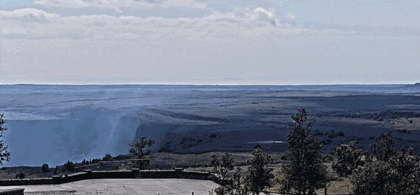
Dominant trade wind conditions generally send tephra and volcanic gas southwest over the remote Kaʻū Desert. Eruption viewing areas within the national park are unaffected, but there can be decreased air quality in communities downwind of Kīlauea due to volcanic gas, vog (“volcanic smog”), and small amounts of Pele’s hair may fall.
Future episodes could occur during less favorable conditions, or during wind patterns affected by hurricanes. This already happened: episodes 15 and 16 occurred during low and variable winds, and Pele’s hair fell on nearby communities—from the Volcano Golf Course to Ohia Estates and beyond. During episode 15, tephra also fell at Uēkahuna and Kīlauea overlooks, resulting in the temporary closure of these popular viewing areas, while during episode 16, tephra fell on Highway 11.
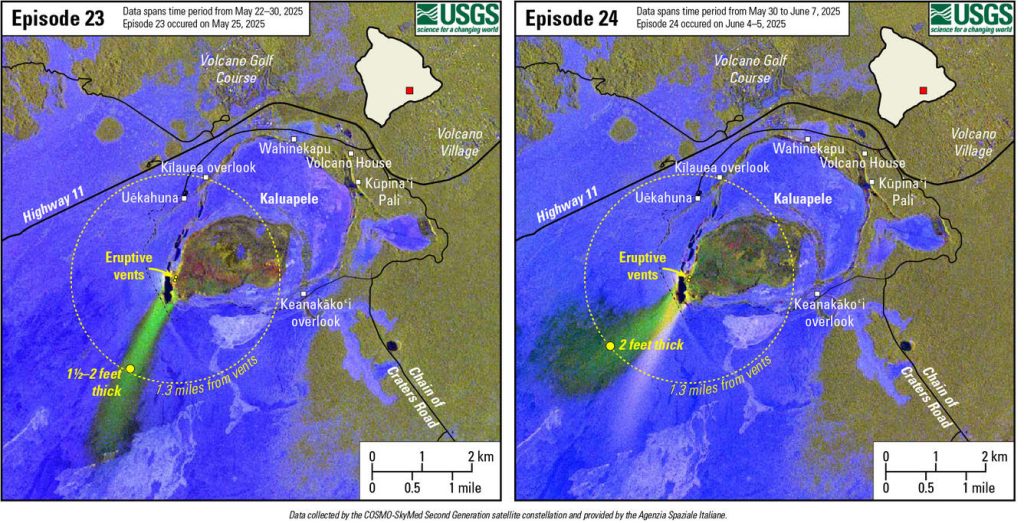
What if an episode occurs during Kona winds (the opposite direction from trade winds)? Recent episodes provide a guide. Episode 23 fountains reached 1,150 feet (350 meters) during strong persistent tradewinds with speeds of 9–14 miles/hour, and episode 24 fountains reached 1,200 feet (365 meters) during tradewinds with speeds of 5–10 miles/hour. Both times, tephra deposits were up to 2 feet thick a mile directly downwind—about the same distance as from the vents to Kīlauea overlook. For both, the tephra deposit was visible in satellite imagery up to 2½ miles away—slightly less than the distance from the vents to Volcano House. This corresponds to an inch or less of tephra.
What about lava fountain angle? Imagine a garden hose blasting water. If the nozzle is pointed straight towards the sky, water will fall back down on the ground nearby—although wind can send the water downwind. This is the default behavior of lava fountains. An “inclined fountain” happens when the nozzle is angled away from the sky (a change in vent geometry) or if there is a partial blockage.
Inclined fountains happened briefly and suddenly in 1959 (Kīlauea Iki) and 1969 (Maunaulu) after the cone partially collapsed into the vent during lava fountaining (a partial blockage). It took up to 20 minutes for the blockages to clear and the fountain to straighten itself. As the nearest viewing areas of the current eruption are over a mile away from the vents, they are not likely to be directly affected in the unlikely event of an inclined fountain.
The USGS Hawaiian Volcano Observatory (HVO) will continue to monitor Kīlauea’s summit eruption and its hazards, working closely with Hawaiʻi Volcanoes National Park and the Hawaiʻi County Civil Defense Agency. The combination of an episodic lava fountain and hurricane season is rare and its good to maintain an awareness of which way the wind is blowing.
Volcano Activity Updates
Kīlauea has been erupting episodically within the summit caldera since Dec. 23, 2024. Its USGS Volcano Alert level is WATCH.
Episode 26 of the Kīlauea summit eruption in Halemaʻumaʻu crater occurred on June 20, with approximately 9 hours of fountaining from the north and south vents. Summit region inflation since the end of episode 26, along with persistent tremor, suggests that another episode is possible and could start between June 29 and July 3. Sulfur dioxide emission rates are elevated in the summit region during active eruption episodes. No unusual activity has been noted along Kīlauea’s East Rift Zone or Southwest Rift Zone.
Maunaloa is not erupting. Its USGS Volcano Alert Level is at NORMAL.
No earthquakes were reported felt in the Hawaiian Islands during the past week.
HVO continues to closely monitor Kīlauea and Maunaloa.
Visit HVO’s website for past Volcano Watch articles, Kīlauea and Maunaloa updates, volcano photos, maps, recent earthquake information, and more. Email questions to askHVO@usgs.gov.
Sponsored Content


