

Monday weather updates: Winds still in the forecast; Flood Watch canceled
Update: 12:52 p.m., Feb. 9, 2026
Wind Warning until 6 p.m. for Maui County and Big Island
A Wind Warning continues for Maui County and the Big Island until 6 p.m. East winds of 25 to 35 mph are expected, with gusts up to 60 mph.
Damaging winds may blow down trees and power lines and damage roofs. Power outages are possible. Travel will be difficult, especially for high profile vehicles.
Update: 12:51 p.m. Feb. 9 2026
Wind Advisory until 6 p.m. Tuesday for Kauaʻi Niʻihau and Oʻahu.
The National Weather Service has cancelled the previous Wind Warning for part of the state and replaced it with a Wind Advisory, now in effect through 6 p.m. Tuesday The forecast still calls for east winds of 20-30 mph, and gusts of up to 50 mph on Kauaʻi Niʻihau and Oʻahu.
Update: 12:09 p.m. Feb. 9, 2026
Flood Watch cancelled
The Flash Flood Watch that was in effect for the Hawaiian Islands has since been cancelled. Flooding is no longer expected to pose a threat, according to the National Weather Service.
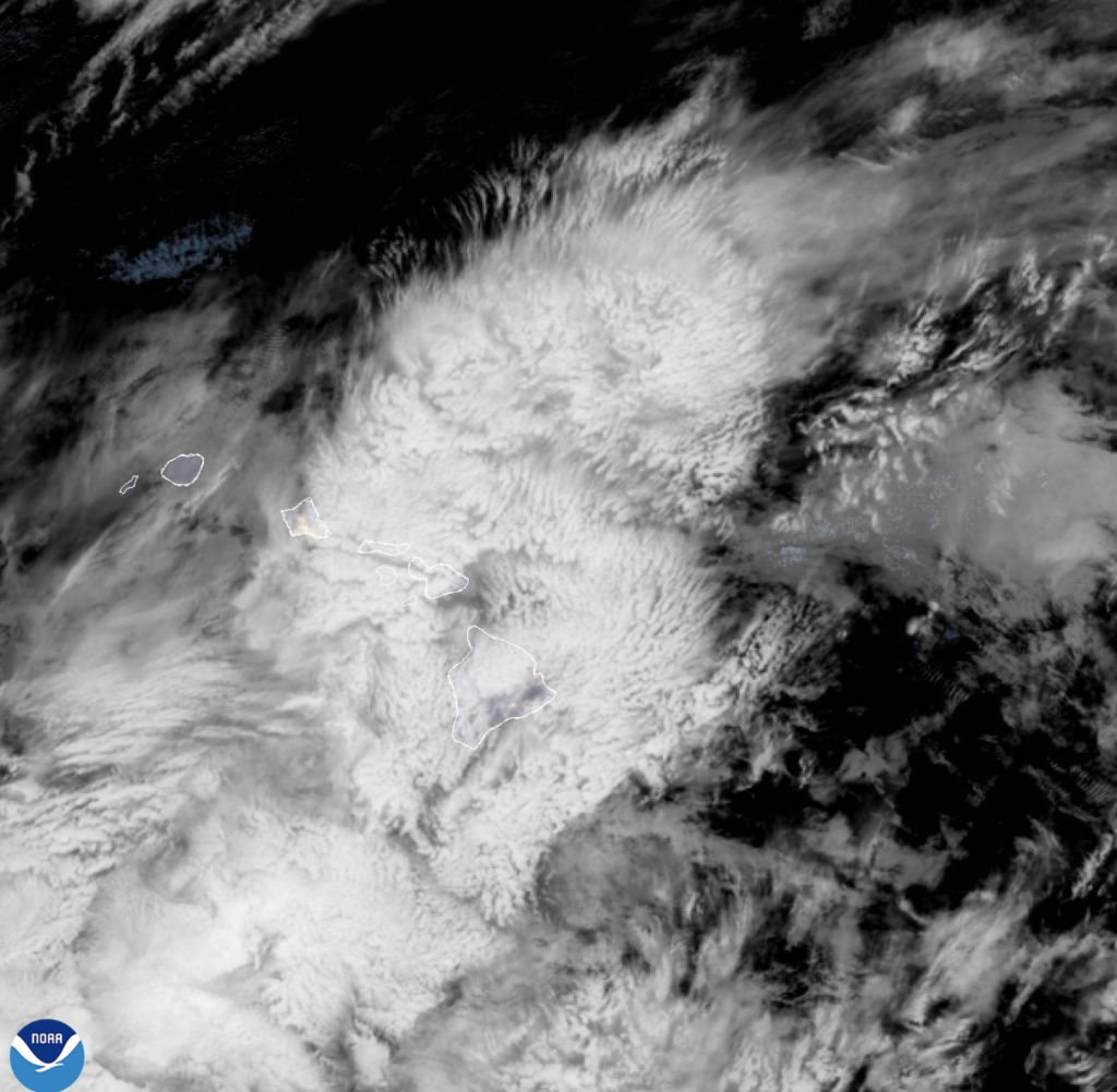
Weather recap:
A High Wind Warning remains in effect for all Hawaiian Islands through this afternoon. On Hawaiʻi Island, many areas around Honokaʻa and Paʻauilo picked up 10 to 12 inches of rain over a 24 hour period. On Maui, the greatest rainfall as of 8 p.m. on Sunday was more than 6 inches at Puʻu Aliʻi and more than 4 inches at rain gauges in Wailuku and Puʻu Kukui.
Strong winds will continue to occur over all islands as well, with the strongest winds in the lee of mountains and in/near stronger showers. Wind gusts of 72 mph were clocked at Olowalu on Maui yesterday morning. Gusts as high as 64 mph were recored in Lahaina, and 62 mph in Kahului.
The NWS reports that wet and windy weather will continue across the islands today, with conditions gradually improving tonight as winds ease up some and rainfall coverage and intensity diminishes. A more typical trade wind pattern will then follow Tuesday through late this week, although it will remain rather breezy.
Update: 7:52 a.m. Monday, Feb. 9 2026
Maui Flood Advisory expires at 8 a.m.
Radar shows that the heavy rain has diminished. Therefore, the Flood Advisory for Maui has been cancelled. Flooding is no longer expected to pose a significant threat. A Flood Watch remains in effect until 6 p.m.
Update: 3:31 a.m., Monday, Feb. 9, 2026
Wind Warning through 6 p.m. Monday
A High Wind Warning is in effect until 6 p.m. for portions of Kauaʻi, Maui, Molokaʻi, Niʻihau, Oʻahu and Hawaiʻi Island. The forecast calls for northeast winds 25 to 40 mph, and gusts of up to 60 mph. Damaging winds may blow down trees and power lines and damage roofs. Power outages are possible. Travel will be difficult, especially for high profile vehicles. Loose outdoor items should be brought inside or secured properly. A High Wind Warning means that winds are expected to be at least 40 mph, with gusts over 60 mph. Stay away from downed power lines.
Update: 3:22 a.m., Monday, Feb. 9, 2026
High Surf Warning for east facing shores
A High Surf Warning is in effect for the east facing shores of Kauaʻi, Oʻahu, Molokaʻi, Maui, Kahoʻolawe and Hawaiʻi Island until 6 a.m. on Tuesday, Feb. 10, 2026. Strong to gale force trade winds will bring large and very rough surf along east facing shores through tonight. Wind speeds will slowly decrease by Tuesday, lowering surf heights along east facing shores into advisory thresholds. Dangerously large breaking waves of 10 to 15 feet are in the forecast. The public should stay away from the shoreline along the affected coasts. Be prepared for road closures. Postpone entering or leaving channels affected by the high surf until the surf subsides.
Previous post:
Update: 5:36 a.m. Feb. 9, 2026
Hawaiʻi Island Flood Advisory extended to 9 a.m.
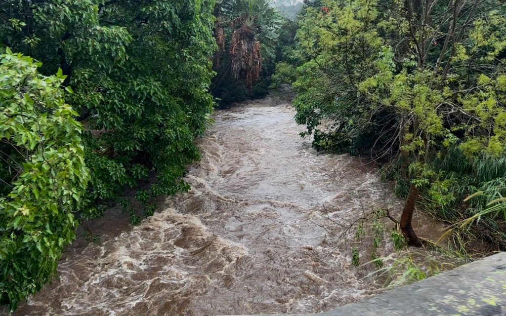
The National Weather Service has extended the Flood Advisory for the Island of Hawaiʻi until 9 a.m. At 5:34 a.m., radar showed heavy rain over portions of the coastal and upslope areas of the Hamakua and Hilo districts. Rain rate trends decrease slightly this morning to 0.5 to 1.0 inch per hour, mainly between Hawī and Laupāhoehoe, particularly over the Puʻu O Umi Natural Area Reserve. This could result in flooding in stream channels and along portions of Highway 19. Some locations that will experience flooding include: Kapaʻau, Honokaʻa, Paʻauilo, Kukuihaele, Waipiʻo Valley, Kamuela, Waimanu Valley, Oʻokala, Laupāhoehoe, Pololū Valley, Nīnole, Kohala Ranch, Halaʻula, Hakalau, Honomū, Hawī, Pepeʻekeo, Pāpaʻikou, Mahukona and Paukaʻa.
Flood Watch through Monday afternoon
A Flood Watch remains in effect for all Hawaiian Islands through Monday afternoon.
NWS forecasters say, “ample moisture remains over the area thanks to a surface trough (the remains of a front) and an upper level low to our west- southwest.”
“This upper low will weaken and slowly drift farther to the southwest and away from the state through Wednesday. A surface high to the north will strengthen overnight, helping keep strong trade winds blowing through tomorrow, with only a little bit of weakening going into Tuesday,” according to the NWS.
The potential for flooding will remain over all islands today, with the highest chance over windward Maui County and windward Big Island. Strong winds will continue to occur over all islands as well, with the strongest winds in the lee of mountains and in/near stronger showers. There is still a slight chance of thunderstorms through today.
After Tuesday, trades will maintain above-normal strength, and windward showers will be plentiful, but the high threat potential through Monday will end.
Update: 4:41 a.m., Monday, Feb. 9, 2026
Maui Flood Advisory extended to 8 a.m. on Monday
The National Weather Service has extended the Flood Advisory for Maui until 8 a.m. At 4:37 a.m., radar showed moderate to locally heavy rain over windward sections of Haleakalā as well as the west Maui Mountains. Rain is falling at a rate of half an inch to 1 inch per hour.
Some locations that will experience flooding include: Kahului, Kīhei, Lahaina, Makawao, Pukalani, Hāliʻimaile, Haʻikū-Paʻuwela, Kula, Pāʻia, Paʻuwela, Huelo, Puʻunēnē, Keʻanae, Māʻalaea, Wailuku, Waiehu, Waikapū, Waiheʻe, Nāhiku and Kīpahulu. As a precaution, the public is asked to stay away from streams, drainage ditches and low-lying areas prone to flooding. A statewide Flood Watch is in effect until 6 p.m. today. This advisory may need to be extended beyond 8 a.m. if flooding persists.
Update: 2:50 a.m. Monday, Feb. 9 2026
Hawaiʻi Island Flood Advisory extended to 6 a.m.
The National Weather Service has extended the Flood Advisory for the Island of Hawaiʻi until 6 a.m. At 2:50 a.m., radar showed heavy rain over portions of the coastal and upslope areas of the Hamakua and Hilo districts. Many areas around Honokaʻa and Paʻauilo have picked up 10 to 12 inches of rain over the past 24 hours. The heaviest late evening rain was falling at a rate of 0.5 to 1.5 inches per hour, mainly between Hawī and Laupāhoehoe, particularly over the Puʻu O Umi Natural Area Reserve. Some locations that will experience flooding include: Kapaʻau, Honokaʻa, Paʻauilo, Kukuihaele, Waipiʻo Valley, Kamuela, Waimanu Valley, Oʻokala, Laupāhoehoe, Pololū Valley, Nīnole, Kohala Ranch, Halaʻula, Hakalau, Honomū, Hawī, Pepeʻekeo, Pāpaʻikou, Mahukona and Paukaʻa.
Update: 1:52 a.m., Monday, Feb. 9, 2026
Maui Flood Advisory extended to 5 a.m. on Monday
The National Weather Service has extended the Flood Advisory for the island of Maui until 5 a.m. At 1:51 a.m., radar showed heavy rain over East, Upcountry and the West Maui Mountains, falling at a rate of 0.5 to near 2.0 inches per hour. Some locations that will experience flooding include: Kahului, Kīhei, Lahaina, Makawao, Pukalani, Hāliʻimaile, Haʻikū-Paʻuwela, Kula, Pāʻia, Paʻuwela, Huelo, Puʻunēnē, Keʻanae, Māʻalaea, Wailuku, Waiehu, Waikapū, Waiheʻe, Nāhiku and Kīpahulu. As a precaution, the public is asked to stay away from streams, drainage ditches and low-lying areas prone to flooding. A statewide Flood Watch is in effect until 6 p.m. today. This advisory may need to be extended beyond 5 a.m. if flooding persists.
Update: 11:54 p.m. Feb. 8, 2026
Flood Advisory extended to 3 a.m. for Hawaiʻi Island
The National Weather Service has extended the Flood Advisory for Hawaiʻi Island until 3 a.m. on Monday, Feb. 9, 2026.
At 11:49 p.m., radar showed heavy rain over portions of the coastal and upslope areas of the Hamakua and Hilo districts. Many areas around Honokaʻa and Paʻauilo have picked up 10 to 12 inches of rain over the past 24 hours. The heaviest late evening rain was falling at a rate of 0.5 to 1.5 inches per hour, mainly between Hawī and Laupāhoehoe, particularly over the Puʻu O Umi Natural Area Reserve. This could result in flooding in stream channels and along portions of Highway 19.
Some locations that will experience flooding include: Kapaʻau, Honokaʻa, Paʻauilo, Kukuihaele, Waipiʻo Valley, Kamuela, Waimanu Valley, Oʻokala, Laupāhoehoe, Pololū Valley, Nīnole, Kohala Ranch, Halaʻula, Hakalau, Honomū, Hawī, Pepeʻekeo, Pāpaʻikou, Mahukona and Paukaʻa.
Update: 11:45 p.m., Feb. 8, 2026
Molokaʻi Flood Advisory cancelled — rainfall has diminished over the Friendly Isle
The Flood Advisory that was in effect for Molokaʻi has since been canceled. Radar shows that the heavy rain has diminished and flooding is no longer expected to pose a threat at the location. A Flood Watch remains in effect until 6 p.m. Monday for Kahoʻolawe, Kauaʻi, Lānaʻi, Maui, Molokaʻi, Niʻihau, Oʻahu, and Hawaiʻi Island.
Update: 10:44 p.m. Feb. 8, 2026
Maui Flood Advisory extended to 2 a.m. on Monday
The National Weather Service has extended the Flood Advisory for Maui until 2 a.m. on Monday, due to flooding caused by excessive rainfall.
At 10:40 p.m., radar showed heavy rain over East, Upcountry and the West Maui Mountains. Rain is falling at a rate of 0.5 to 1.5 inches per hour. Some locations that will experience flooding include: Kahului, Kīhei, Lahaina, Makawao, Pukalani, Hāliʻimaile, Haʻikū-Paʻuwela, Kula, Pāʻia, Paʻuwela, Huelo, Puʻunēnē, Keʻanae, Māʻalaea, Wailuku, Waiehu, Waikapū, Waiheʻe, Nāhiku and Kīpahulu.
As a precaution the public should stay away from streams, drainage ditches and low-lying areas prone to flooding.
A statewide Flood Watch is also in effect until 6 p.m. on Monday.
Sponsored Content


