‘Increasingly active weather pattern’ to persist through Friday as storm strengthens
It’s not finished yet, and even when this round of stormy weather moves away from the islands, it looks like another will be right behind it.
“An increasingly active weather pattern unfolding across the Hawaiian Islands will persist through Friday as low pressure strengthens northwest of the state,” said National Weather Service in its area forecast discussion at just before 9 p.m. Wednesday, April 8.
An extratropical cyclone, which is different than a kona low, is drawing deep tropical moisture north into the islands which will continue to support periods of heavy rainfall and strong southerly winds. Isolated strong to severe thunderstorms also are possible, particularly from Thursday through Friday.
Heavy rain was forecast to continue overnight Wednesday, April 8, and again through Thursday and Friday, April 9-10.
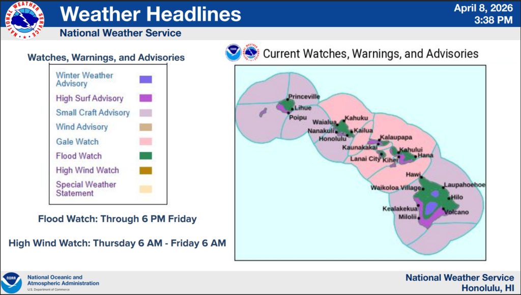
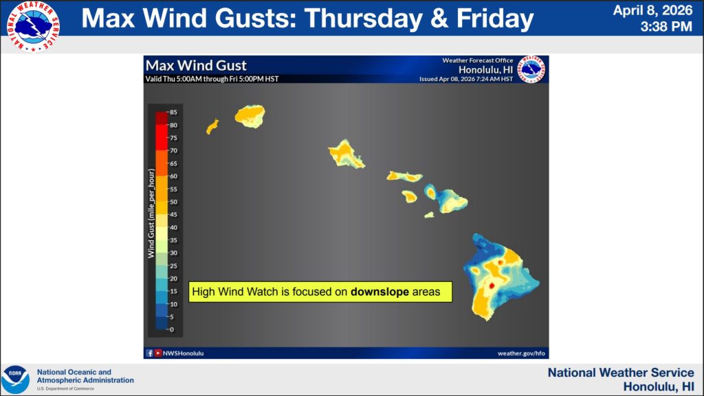
National Weather Service forecasters in Honolulu issued a wind advisory that will be in effect from 2 p.m. Thursday until 6 p.m. Friday for Big Island summits. A winter weather advisory for areas above 12,500 feet is also still in effect until Friday morning, with snow and freezing rain combining with gusty winds to create hazardous conditions.
Meanwhile, at the north end of the state, heavy rain with moderate southeast winds was forecast overnight Wednesday for Kaua‘i before an even better chance for excessive rainfall Thursday bringing with it strong south-southeast winds. A high wind warning in effect until 6 a.m. Friday replaced a previous high wind watch issued for north and interior mountain portions of Kaua‘i.
The pattern will pretty much remain the same Friday on the Garden Isle, but winds will become more moderate and from the south-southwest.
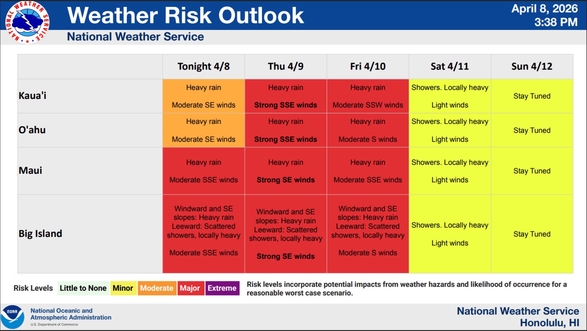
Additional rounds of heavy rainfall — drowning the already more-than-soggy soils — that could include some isolated thunderstorms will also increase the threat of more flooding on both islands through the end of the work week and possibly even into Saturday, April 11.
“Periods of moderate to locally heavy rain [are] moving in from the south,” said National Weather Service in Honolulu. “It will not take much rain to induce flash flooding.”
A flood watch remains in place for all Hawaiian islands through Friday afternoon.
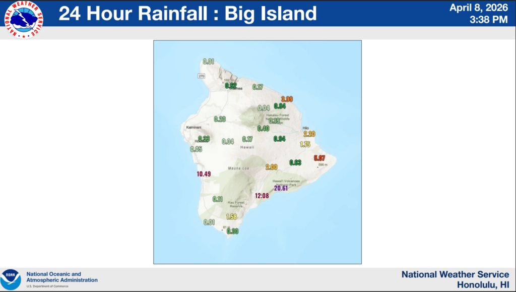
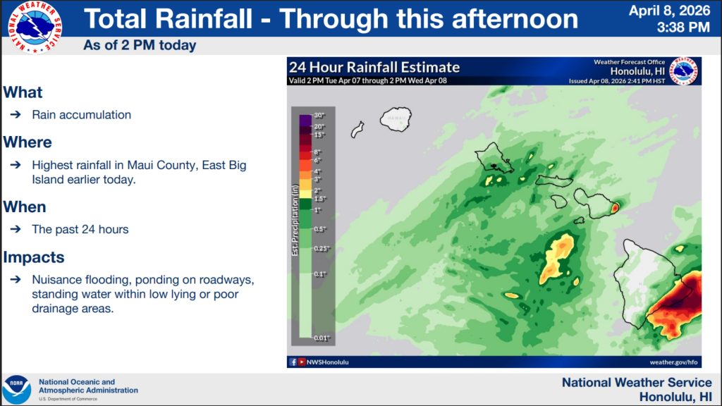
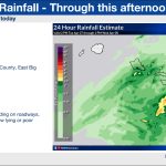
The heaviest and most rain observed Wednesday fell in eastern Maui and southern and southeastern parts of Hawai‘i Island, causing nuisance flooding, ponding on roadways, standing water within low-lying or poor drainage areas.
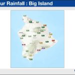
Big Island rain gauges collected several impressive rainfall amounts during the 24-hour period ending by about 3:30 p.m. Wednesday, the most being 20.61 inches at a location within Hawai‘i Volcanoes National Park near the coast.
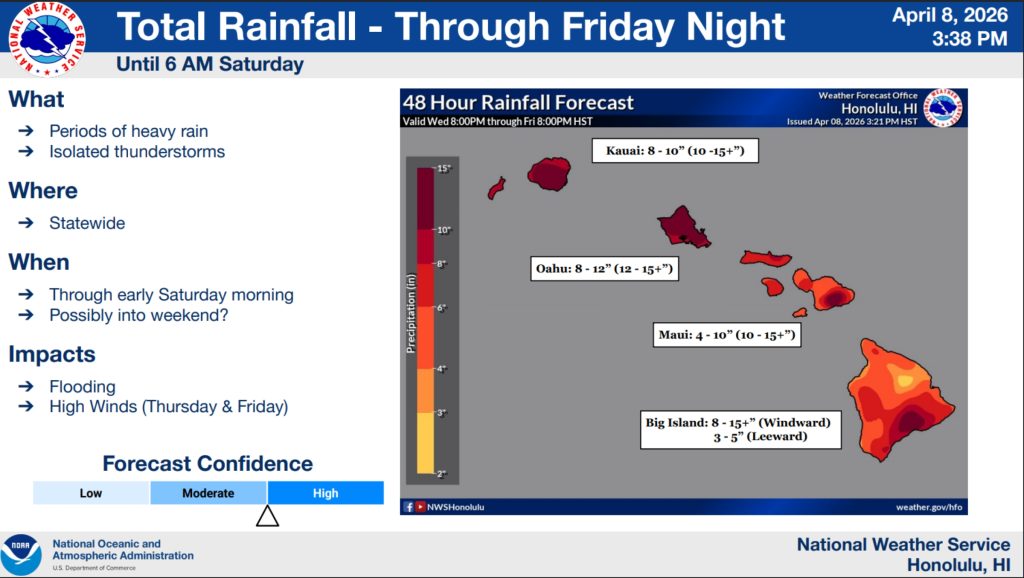
Total rainfall amounts through 8 p.m. Friday are forecast at a possible 8 to 15 inches on Hawaiʻi Island — or even more in some spots — on the windward side of the island and 3 to 5 inches on the leeward side.
Kaua‘i County could see 8 to 10 inches of total rainfall during the same time period, with potentially localized amounts of up to 10 to 15 inches.
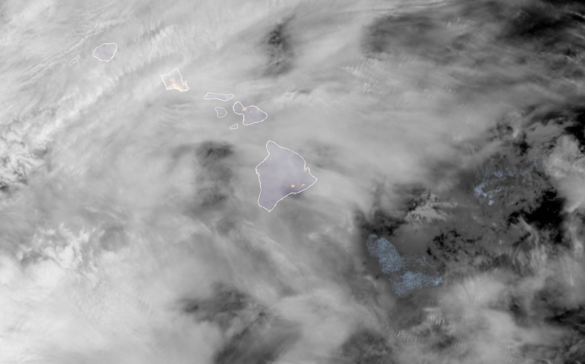
 Courtesy Graphic: National Weather Service
- Courtesy Graphic: National Weather Service
- Courtesy Graphic: National Weather Service
“Our determination, using various diagnostic tools in-house, is that this current low to our northwest is an extratropical low,” said National Weather Service Honolulu Forecast Office Science and Operations Officer Robert Ballard on Wednesday.
The decision was based on the system’s structure, including its cold-core nature, location at relatively high latitudes, persistent frontal structure and its progressive nature — not remaining stationary for a long period of time.
All three types of cyclones — tropical cyclones such as hurricanes, subtropical cyclones including kona lows and extratropical cyclones — can bring similar, severe impacts, including intense, persistent rainfall and flash flooding, as well as damaging winds.
Damaging winds can be enhanced by terrain, blowing downslope from mountains, and thunderstorms. By their nature, extratropical cyclones tend not to linger near the islands as long as kona lows, but this is not always the case.
He added that “kona low” is a term for a relatively rare, impactful weather system that affects Hawai’i on an irregular, infrequent basis.
Some years the state experiences one or two of the subtropical cyclones, but many years there are none near Hawai‘i.
The local term for the name for these types of cyclones has been used since 1952.
Subtropical cyclones often evolve from extratropical lows that remain over sufficiently warm waters long enough to lose their frontal structure and develop weak, shallow warm-core-like features with time — including loosely organized convection near the center.
And while the storm swamping an already soggy state isn’t a kona low, it will still prove to leave its mark.
“Again, we want to stress to everyone that regardless of the meteorological designation, severe impacts can and do occur from weather systems in Hawai‘i that are not kona lows,” Ballard said.
- Courtesy Graphic: National Weather Service
- Courtesy Graphic: National Weather Service
So don’t let your guard down — even when weather conditions seem to improve.
“Although some brief improvement for portions of the state is possible by Saturday, another active period appears likely from Sunday through early next week,” National Weather Service said in its area forecast discussion.
Get the latest advisory, watch and warning information and forecast details from the National Weather Service Honolulu Forecast Office website.
Sponsored Content