


Mokuʻula in focus: Input sought on master plan for Lahaina Royal Complex, building a ‘living framework’
“Ola ka ʻāina, ola ke kanaka.: When the land thrives, so do its people.” – ʻōlelo noʻeau
Residents of Maui and Hawaiʻi – especially those from Lahaina – are invited to participate in an online survey to help shape the master plan for restoring Lahaina’s historic Royal Complex, Luaʻehu.
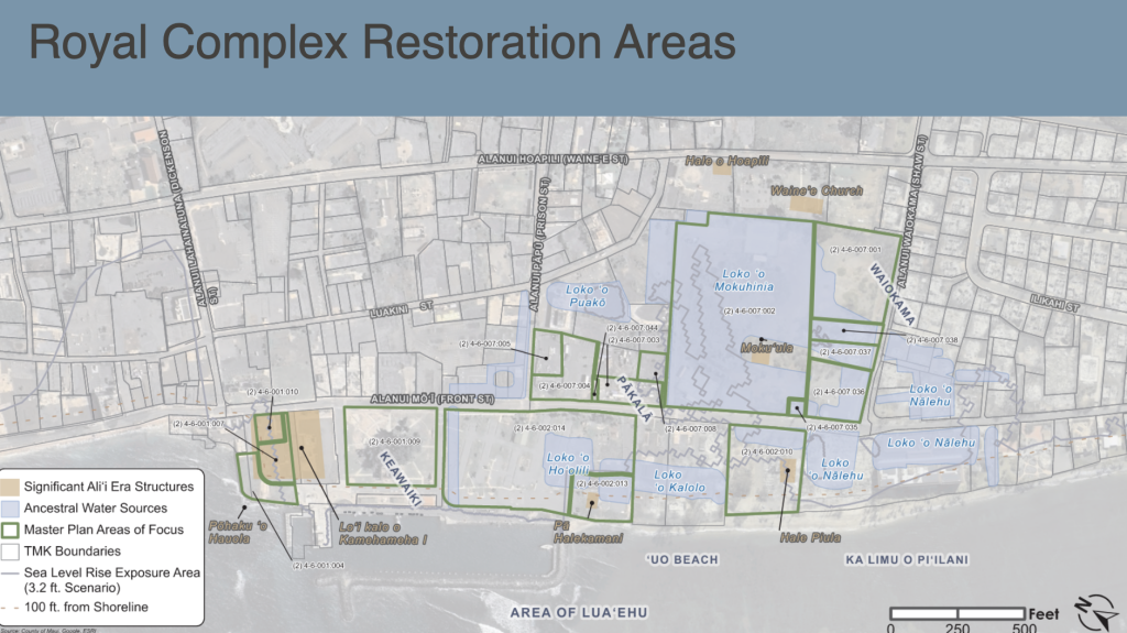
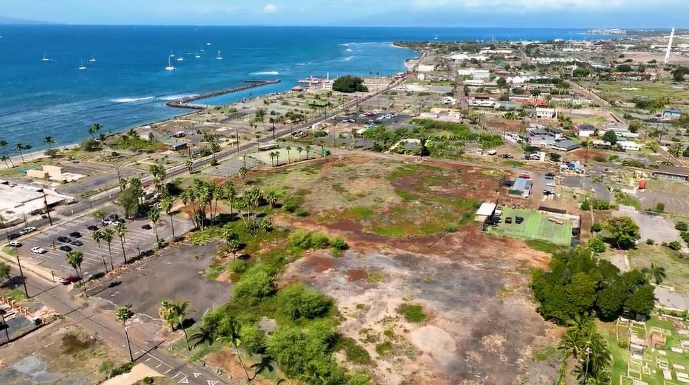
The master plan area encompasses a deeply sacred area in the heart of Lahaina that includes Mokuʻula, Loko o Mokuhinia, Pākalā and Loko o Nālehu, surrounding what was formerly known as Malu ʻUlu o Lele Park. It also includes the pre-fire site of Kamehameha III Elementary School.
“We want that place to be able to be a space where people can continue to walk, understand the storylines, and make sure that we’re telling our story today,” said County of Maui Department of ʻŌiwi Resources Director Kaponoʻai Molitau.
“It’s not only about the whaling era and missionary era, but there’s a whole Hawaiʻi story… that we haven’t told. And that’s the exciting part — to uplift that community of moʻolelo (story), to uplift that community of ‘ike kupuna (ancestral knowledge), as well as the dynamics of the Kamehameha dynasties that lived there at one point,” including the history prior to that time.
– Kaponoʻai Molitau, Director of County of Maui Department of ʻŌiwi Resources
Timeline calls for final Master Plan in 2027
This step comes after the information was shared with the Lahaina community during a regularly scheduled recovery meeting, Wednesday. During the gathering, a timeline was shared with goals of presenting a master plan in the spring of 2027.
“This master plan is a community-led, government-supported effort to restore and honor one of Lahaina’s most significant cultural places,” Mayor Richard Bissen said. “Together, our shared vision will support healing and perpetuate Lahaina’s historic Royal Complex for generations.”
Molitau said, “There’s a phase zero approach currently, with the clearing of all the clay courts, the basketball courts, the old baseball fences, etc. [We’re] trying to get at least down to ground zero, making sure that we can see what the landscape looks like, and go from there.”

During Wednesday night’s meeting, the department’s planning team from G70 and SR Partners introduced a tentative timeline for next steps, which include:
- Research and technical studies: summer 2026 – spring 2027
- Community gatherings and learning: summer 2026 – early 2027
- Planning, design and implementation gatherings: fall 2026 – spring 2027
- Draft plan review: first quarter 2027
- Community review and refinement: spring – summer 2027
- Final master plan delivery: summer 2027
Background and vision for the sacred site
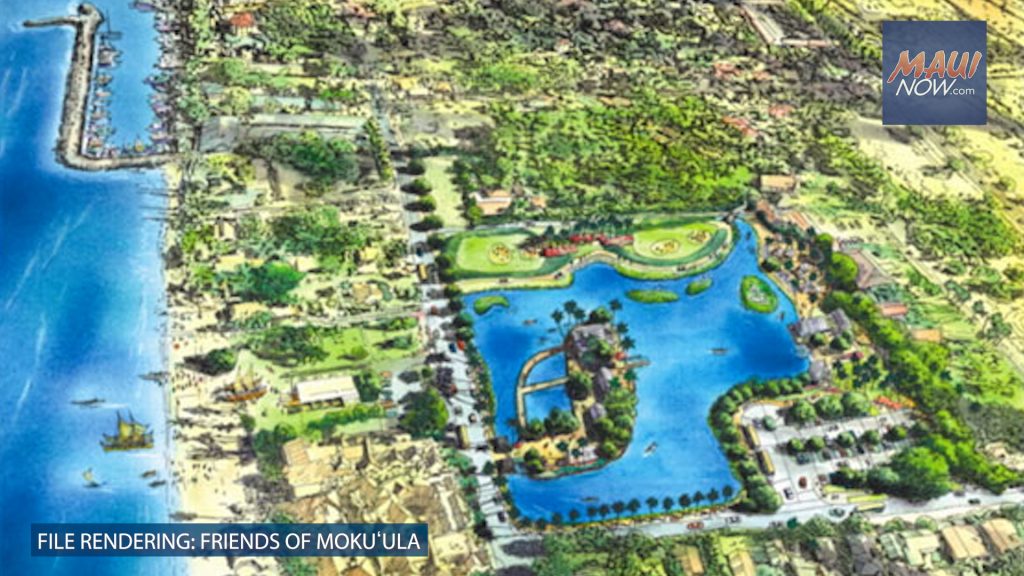
Visions surrounding the restoration of Mokuʻula Island and Loko o Mokuhinia have circulated for generations including more than 20 years of efforts led by the late “Akoni” Akana, a cultural advocate and kumu hula who established the Friends of Mokuʻula in the hopes of reviving the sacred site.
“We all look at some of the, the old sketches and drawings and images of what Mokuʻula and Mokuhinia could look like,” said Molitau. “I think for us as young kids, we all have that same image in our head,” he said. The goal now is to be co-creators, drawing on a collective vision to educate, empower and uplift.
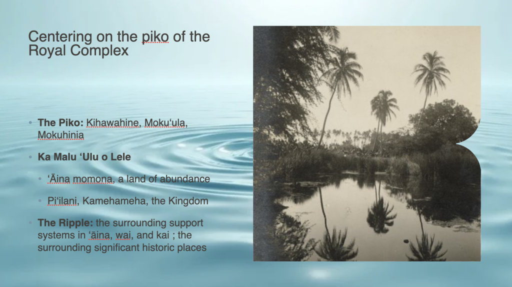
Historically celebrated as ʻāina momona (a land of abundance) defined by freshwater resources, fishponds and royal residences, the site serves as the historical political capital of the Hawaiian Kingdom, according to officials with the County Department of ʻŌiwi Resources, which is leading the multiyear master planning process..
In 2008, a background history and review of historic preservation efforts at Mokuʻula were initiated, along with recommendations for the proposed Mokuhinia/Mokuʻula Ecosystem Restoration Project. A Cultural Impact Assessment and Draft Archaeological Inventory Survey were completed in the years that followed.
Previous reports note that Loko o Mokuhinia was a 17-acre pond that is cited in Hawaiian traditions as the home of Kihawahine, a deity in royal lineage, and guardian for the sacred Mokuhinia ponds and Mokuʻula Island. State documents described the island as the preferred residence of high ranking aliʻi through the mid-1800s.
An Environmental Assessment filed for the project in 2013 notes that the pond was filled in 1914 due to hygienic and development purposes when it became stagnant. Several years later, in 1918, an executive order established the site as Maluʻulu o Lele Park, with the pond and island located approximately 2 to 3 feet below ground, according to state documentation.
Restoring glory: Charting a course for healing
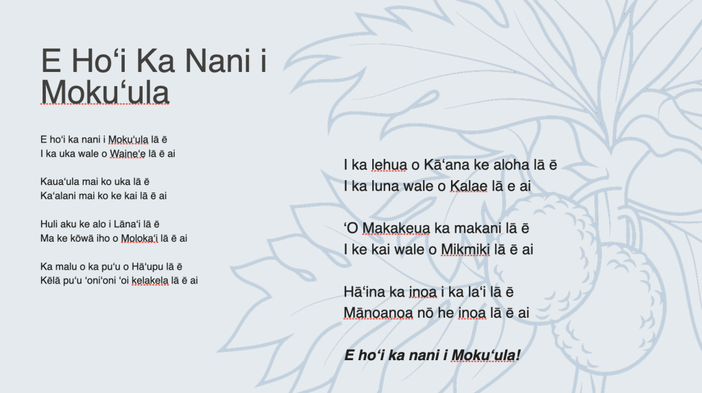
Rooted in the guiding principle “E Hoʻi ka Nani i Mokuʻula” (Restoring the glory to the Royal Complex), the master planning process aims to weave together the community’s vision with technical research to establish a strategic roadmap for cultural and ecological “servantship.”
Following the 2023 fires, the Royal Complex Master Plan is charting a course for long-term cultural, ecological and community healing focusing on “ola ka ʻāina, ola ke kanaka — when the land thrives, so do the people,” according to the County Department of ʻŌiwi Resources.
“While the sacred center of Mokuʻula and Mokuhinia will continue to be shaped primarily by cultural practitioners and those with ancestral kuleana, the broader ripple effect of the Royal Complex touches public access, infrastructure and traffic flow that impacts the entire island chain,” Molitau said.
Residents are encouraged to complete the online survey (https://arcg.is/0mbmDy) to voice their perspectives on what they seek to learn from this space and what they seek to offer.
Finding balance: Carrying ancestral knowledge forward
On the one-year anniversary of the 2023 Maui wildfires, Gov. Josh Green, M.D. signed papers to “purposefully transition” Mokuʻula from the state to Maui County for its cultural and ecological restoration.
Molitau reflected on the magnitude of the wildfire including its impacts and the return of water to storied sites.
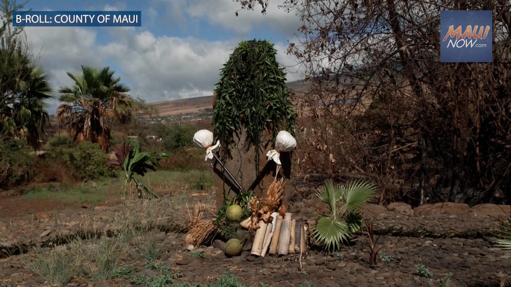
“How do we bring ʻāina momona (fertile/rich land) concepts back to this particular space? Really, the land is showing that to us already by returning the wai (water),” he said, noting the return of water to Nālehu in the 505 Front Street area.
“For many, many, many moons, it’s been pumped out constantly. Now that the pump systems don’t work anymore, you’re seeing a lot of these kupuna (as we will call them, because they are a part of our ancestral realm)— come back, and showcase themselves,” said Molitau.
“The pahu manamana (intersection, crossroads) ʻauwai (canal) is full. It’s full of life that is really relevant to that space called Mokuhinia. You’re seeing a lot of these particular spaces come back. And how do we address that? How do we make sure that we manage them correctly moving forward?” he said.
Molitau also reflected on the path forward in seeing the potential in what remains.
“We have an opportunity to do this correctly, in terms of restoring ʻāina (land) to balance, looking at ancestral oli (chant), looking at ancestral mele (song) as roadmaps to be able to see… this is really important to how we should care for ʻāina,'” said Molitau.
“I think that validation of those kinds of ʻike kupuna should be held in the same level as how we care for land today from a scientific approach (hydrology study, the ecology study, all of the studies),” he said, “understanding that equivalent to all of that, is all the ʻike kupuna, and they should be held at the same standard.”
Living framework spans generations
The completion of a master plan does not translate to immediate construction, but rather establishes a “living framework” for subsequent environmental reviews, historic reviews, permitting and multi-phase implementation over generations, according to department officials.
To ensure the resulting framework is comprehensively viable and ecologically sound, the planning team shared an updated accountability scorecard tracking the critical environmental, regulatory and historic reviews. Other finished and ongoing work includes:
- A baseline geotechnical overview study has been completed by Geolabs Inc.
- Ongoing research across a variety of disciplines, including archaeological and cultural resource tracking, hydrological mapping of ancestral water sources, wetland biology assessments, aerial imagery and topography work, traffic and circulation analysis.
- In-depth review of existing land and water use regulations.
- Components for conceptual landscape design and comprehensive wildfire resilience planning are scheduled to begin.
ARTICLE CONTINUES BELOW AD“This is not for this particular generation, but it’s really for the next seven generations that we’re planning this for. We have to think about this particular program and really this particular restoration effort for our great- , great- , greats- — for them to be able to understand what is possible,” said Molitau.
- For questions about the Royal Complex Master Plan process or to submit feedback via email, contact LRC@g70.design.
- For general information on the County of Maui Department ʻŌiwi Resources, visit https://www.mauicounty.gov/2916/Department-of-iwi-Resources.
Sponsored Content


