

Flossie Expected to Near Big Island in 60 to 72 Hours
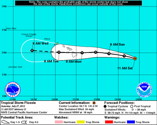
Flossie 5-day Track issued at 11 a.m. 7/27/13. Courtesy NOAA, NWS, CPHC.
By Wendy Osher
(Update: 5 p.m. Sat. July, 27, 2013)
The National Weather Service, Central Pacific Hurricane Center issued a tropical storm watch for Hawaii and Maui Counties as Flossie continues moving westward toward Hawaii.
Officials with the state Civil Defense agency say the NWS forecasts possibly 6-10 inches of rain and potential sustained winds of 30-40 mph in some parts of the state as early as Monday. High surf and some storm surge is also predicted in some coastal areas.
At 5 p.m., the system was located at latitude 19.0N and longitude 143.2W, and was about 775 miles east of Hilo, Hawaii.
Maximum sustained winds were measured at 50 mph with the system moving west at 20 mph. Minimum Central Pressure was 1000 mb or 29.53 inches.
A tropical storm watch means that tropical storm conditions are possible within the watch area within 48 hours. Some weakening is forecast over the next 48 hours.
Forecasters say tropical storm force winds extend outward up to 175 miles from the center of the storm.
Rainfall and heavy rain may begin as early as Monday morning over Hawaii County and Monday afternoon over Maui County.
Tropical storm force winds are expected as early as Monday afternoon.
Large surf will impact East facing shores as early as Sunday afternoon with the largest surf expected on Monday.

Flossie Wind Speeds issued at 8 a.m. 7/27/13. Courtesy NOAA, NWS, CPHC.
(Update: 11 a.m. Saturday, July 27, 2013)
Tropical Storm Flossie is slowly weakening, but is still expected to bring increased winds and rain to Hawaiʻi Island by Monday, forecasters said. “Almost all of the models show Flossie near the Big Island in 60 to 72 hours,” according to the latest forecast from the Central Pacific Hurricane Center.
A Hydrolic Outlook issued by the National Weather Service says, “The latest forecast for Tropical Storm Flossie still has the system moving across the island chain early next week as a weakening tropical cyclone. Abundant tropical moisture associated with Flossie will bring elevated potential for very heavy rainfall and flash flooding for parts of the state on Monday and Tuesday.”
At 11 a.m. the storm was located near latitude 18.7 north, and longitude 141 west, about 920 miles east of Hilo, Hawaiʻi and 1,010 miles east of Kahului, Maui, according to information released by the Central Pacific Hurricane Center.
According to forecasters with the National Weather Service’s Central Pacific Hurricane Center, the system is moving toward the west-northwest near 18 mph, with motion expected to continue for the next 24 hours. Some weakening, officials say, is expected during the next 48 hours.
Forecasters say the storm is expected to make a gradual turn toward the west and decrease in forward speed on Sunday.
Maximum sustained winds are reportedly near 50 mph with higher gusts, and tropical storm force winds extending outward up to 150 miles from the center. Estimated minimum central pressure was last measured at 1000 mb or 29.53 inches.
Officials with the state civil defense agency said that although the system is expected to weaken in intensity, it could still produce heavy rain and possible flooding in some parts of the state.
There are currently no watches or warnings in effect, however authorities may issue a flash flood watch or warning as the system nears.
State Civil Defense reminds residents and visitors to take appropriate precautions by being aware of dangers such as streams and other areas prone to flooding and mudslides. Ground saturation caused by the heavy showers can increase the danger of flash floods, mudslides, and rockslides in affected areas.
Civil defense authorities are encouraging residents to continue to prepare for Hawaii’s ongoing wet weather season, which runs from October to March.
Precautions suggested include determining if you live or work in a flood zone, listening for flash flood watches and warnings broadcast on radio and TV, and reinforcing homes against potential flood damage.
***Supporting information courtesy NWS, NOAA, CPHC and State Civil Defense.
Sponsored Content


