

5 p.m. UPDATE 8/4/15: Guillermo Forecast to Pass 120 Miles NNE of Maui

Image: NWS satellite at 5:30 p.m. on August 4, 2015
By Meteorologist Malika Dudley / Email: malika@mauinow.com
***Updated at 5:00 p.m.***
The latest Central Pacific Hurricane Center forecast estimates the center of Guillermo will pass approximately 150 miles northeast of the Big Island on Wednesday night, and approximately 120 miles north-northeast of Maui Wednesday night.
Tropical Storm Guillermo is now 435 miles E of Kahului, 490 miles E of Kaunakakai and 470 miles E of Lanai City. Maximum sustained winds are still at 70 mph and the system is moving WNW at 9 mph.
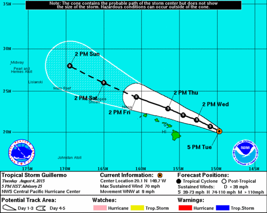
Image: CPHC forcast track at 5:00 p.m. on August 4, 2015
The forecast calls for a steady weakening with Guillermo becoming a tropical depression after day 3. The forecast track has been nudged slightly closer to the islands with this forecast update and a bit slower as well. Because of these changes, the Tropical Storm Watch will remain posted.
A jog to the right, north or east means we will see lesser effects from this storm. Whereas, a jog to the left, south or west could mean tropical storm conditions for parts of the state.
Movement and intensity forecasts overnight will determine whether watches and advisories are upheld or cancelled.
Click here for tips and preparedness information.
***Updated at 2:05 p.m.***
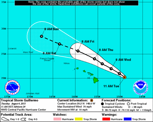
Guillermo is still a tropical storm with maximum sustained winds at 70 mph. As of the 2 p.m. CPHC update, the storm is 465 miles E of Kahului, 520 miles E of Kaunakakai and 495 miles E of Lanai City. The system has slowed down a bit and is moving WNW at 8 mph.
A Tropical Storm Watch is still in effect for Maui County and the Big Island. The chance for tropical storm force winds is 5 percent for Kahului. This represents a general downward trend since the last forecast. Keep in mind, tropical storm force winds are still possible Wednesday into Wednesday night and if the track changes the forecast also changes as a result. For more forecast guidance and detailed weather prediction, see previous posts.
11 a.m. CPHC forecast track
***Updated at 10:50 a.m.***
A Flash Flood Watch is in effect until 6:00 p.m. Thursday for Maui and the Big Island. Abundant moisture from Tropical Storm Guillermo moving over the area. Excessive runoff may result in rock and mudslide in steep terrain. Fast-moving water may create life-threatening situations.
A High Surf Advisory is posted for east facing shores of Maui and Moloka’i from midnight to noon Thursday. East swell generated by Guillermo currently affecting the Big Island and Maui will build as it spreads across the island chain tonight and Wednesday. Surf is expected to peak early Wednesday for Maui and late Wednesday for Moloka’i. Surf is expected around 5 feet this evening, increasing to 6 to 10 feet late tonight and Wednesday, before declining on Thursday.
The track has again been nudged north as of the 11 a.m. update. Guillermo is forecast to remain well northeast of the Hawaiian islands at its closest point of approach. If this motion continues and there is no significant deviation to the left of the forecast track, the Tropical Storm Watch for the Big Island and Maui County may be cancelled later today or tonight.
Guillermo is now 480 miles E of Kahului, 535 miles E of Kaunakakai
and 510 miles E of Lanai City. Maximum sustained winds are still at 70 mph as of the 11 a.m. CPHC update and the system is moving NW at 10 mph. The system should weaken and dissipation is expected in 72 hours.
***Updated at 5:00 a.m.***
Guillermo is a bit stronger this morning than it was for much of yesterday, now a tropical storm with maximum sustained winds of 70 mph. The storm, located about 520 miles E of Kahului, 570 miles E of Kaunakakai and 550 miles E of Lanai City, continues to move NW at 12 mph.
The track forecast has the system continuing in this general motion through today. Tonight and Thursday Guillermo is expected to shift WNW.
If this track remains true, the center of Guillermo should pass 215 miles northeast of Hilo Wednesday afternoon and around 165 miles north of Maui Wednesday night with tropical storm force winds currently extending about 175 miles from the center. The moisture field extends even beyond that.

IMAGE: NWS at 5:15 a.m.
There is potential for slight strengthening today but the system looks a little less organized this morning compared to late last night. We’re seeing warmer cloud tops and less thunderstorm activity on satellite. Slow and steady weakening is expected from then on as vertical wind shear takes over again and starts to tear the storm apart. Sea surface temperatures are still sufficiently warm to sustain a hurricane so we can’t rule that out from the possibilities.
A Tropical Storm Watch is posted just in case the system decides to jog left of the expected track. If that happens, tropical storm conditions are possible within the next 48 hours somewhere within the watch area.
A watch is typically issued before the possible arrival of tropical storm force winds which make continuing outside preparations dangerous. Having said that, the probability of tropical storm force winds is currently 11 percent for Hilo and 13 percent for Kahului. Which is a general downward trend from yesterday.
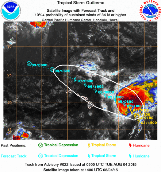
Image: CPHC at 5 a.m. Tuesday August 4, 2015
The chance for heavy rain and thunderstorms continues Wednesday and Thursday. Total rainfall amounts of 1 to 3 inches with isolated maximum amounts near 7 inches (in higher terrain) are possible. If the system tracks closer to us, those numbers could go up. If Guillermo tracks farther away from us, rainfall amounts will be lower. Winds are expected to remain below 39 mph but only a slight shift left could result in higher winds so we need to keep watching.
A High Surf Advisory is still in effect through today for the Big Island and large swells are expected through much of the week.
DETAILED WEATHER FORECAST UPDATE:
Based on the current track (5 a.m.), mostly cloudy skies and windy conditions are expected Wednesday and Thursday with heavy rain likely in windward locations. Leeward spots have a chance of heavy rain through the day, then heavy rain is likely Wednesday night and Thursday.
There is a slight chance of thunderstorms Wednesday night and Thursday. Northeast winds are expected from 15 to 20 mph becoming variable up to 15 mph on Thursday.
Over the weekend we should get our easterly winds back from about 15 to 20 mph. Showers are likely in windward spots with scattered leeward showers and mostly cloudy skies.
Sponsored Content


