

High Surf Warning in Effect for East Exposures

Image: John Varney
Alerts (as of 1:00 a.m.)
A Tropical Storm Watch is posted for Maui County. A watch is issued 48 hours before the possible arrival of tropical storm force winds.
A Flash Flood Watch has been issued by the National Weather Service. It goes into effect late Friday night and will be posted through Sunday afternoon. Tropical Storm Darby is expected to continue approaching the Hawaiian Islands. The forecast is still highly dependent on the track and intensity of the system, however, there is a possibility for intense rainfall and flash flooding this weekend. East to southeast facing slopes are at greatest risk.
When rainfall episodes of this intensity occur, flooding could occur even outside of normal flood zones. Keep in mind, flooding on roadways can make driving very dangerous and roads impassable. Two feet of water is enough to sweep your car away. Debris can clog waterways. Never try to cross fast-flowing water on foot.
A High Surf Warning is also posted for the east facing shores of Maui from 6 a.m. Friday to 6 a.m. Sunday. Surf is forecast to build to 12 to 20 foot faces Friday with higher sets at the best exposures. Waves this big can cause coastal flooding and lead to dangerous ocean conditions. Powerful currents are also a concern and large breaking waves can impact harbor entrances and channels.
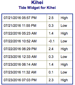
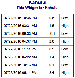
**Click directly on the images below to make them larger. Charts include: Maui County projected winds, tides, swell direction & period and expected wave heights.**
 Maui Surf Forecast
North: Wave heights are expected to be around head high to overhead for spots catching the building Darby generated swell. Double overhead or more at the best exposures on Maui.
West: Surf is ankle/knee high today. The best breaks could get up to tummy/chest high on the sets.
South: Surf is knee/chest high today.
Our current south-southwest swell is still fading. A new southerly swell is expected for around July 31st.
 Darby swell is expected to peak Friday at warning levels before slowly fading through the weekend. Still highly dependent on Darby’s progress as it approaches the state. At this point, Estelle and Frank are not likely to send significant swell to the Hawaiian Islands.
Keep in mind, surf heights are measured on the face of the wave from trough to crest. Heights vary from beach to beach, and at the same beach, from break to break.
**Click here for your detailed Maui County weather report.**
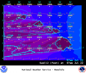
Image: NOAA
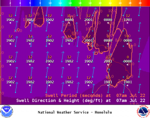
Image: NOAA
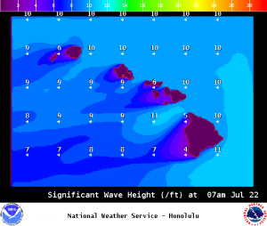
Image: NOAA
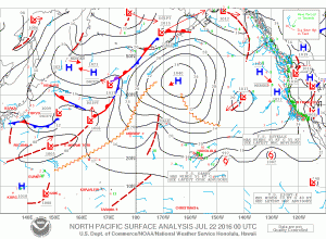
Image: NOAA
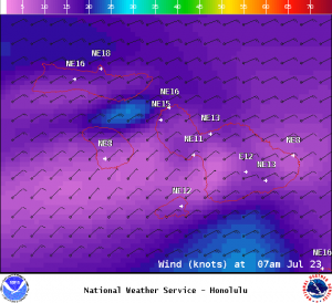
Image: NOAA
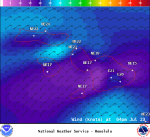
Image: NOAA
Sponsored Content


