

HVO Logs Renewed Seismic Activity at Lō‘ihi
Just over a month ago, the Hawaiian Volcano Observatory raised the curtain on its new website. The change was part of an overall update to how the U.S. Geological Survey’s Volcano Hazards Program provides information to both the scientific community and the general public.
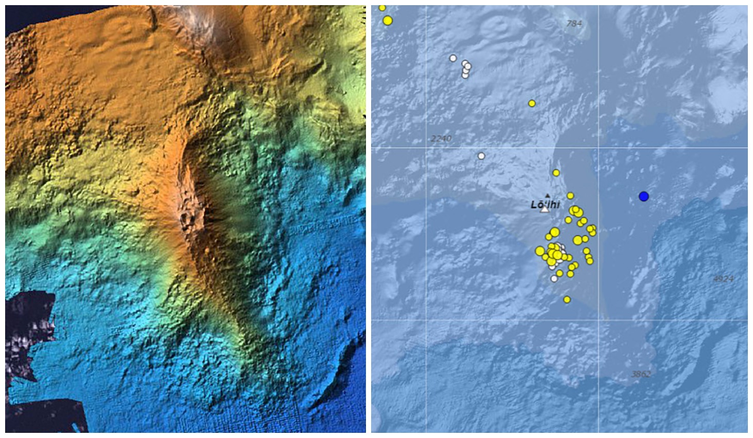
Left: A color-shaded bathymetry map of Lō‘ihi, a submarine volcano located southeast of the Island of Hawaiʻi. The summit region is marked by pit craters formed in connection with an eruption and earthquake swarm in July–August 1996. Right: Earthquakes in the vicinity of Lō‘ihi (same area as bathymetry map) located by the USGS Hawaiian Volcano Observatory during a 30-day period ending June 22, 2017. Locations of the earthquakes are shown with dots; size indicates magnitude and color indicates time (blue represents earthquakes within two days of June 22, yellow within two weeks, and white within four weeks). For example, the blue dot east of Lō‘ihi was a magnitude-2.3 earthquake that occurred on June 22. Photo Courtesy HVO
The new HVO website provides a portal to a wide range of information about the two ongoing Kīlauea eruptions and current unrest on Mauna Loa. Other Hawaiian volcanoes are also featured on the website, including the island chain’s youngest and still submarine volcano, Lō‘ihi.
Somewhat coincident with the debut of HVO’s updated website, eagle-eyed web surfers have noticed recent increases in earthquake activity at Lō‘ihi. Although we have no seismic stations near Lō‘ihi, which is centered 24 miles southeast of Pāhala in Hawai‘i County’s Ka‘ū District, HVO has been tracking earthquake activity there from land-based seismic stations for over 50 years.
Indeed, since the end of February 2017, HVO seismic analysts have noted a slight uptick in the numbers of earthquakes near Lō‘ihi. From January 2015 through February 2017, there was, on average, one located Lō‘ihi earthquake per month. Since then, the rate of earthquakes has gradually increased. This month alone (as of June 22), there have been 51 located earthquakes in the Lō‘ihi region.
Without permanent seismic stations at Lō‘ihi—because the highest point of the volcano is still a kilometer (0.6 mi) under water—it is not possible to locate earthquakes there as accurately as we can at Kīlauea or Mauna Loa. However, we can state that the June 2017 earthquakes appear to be clustered roughly 6–7 miles below sea level and extend from beneath the summit region of Lō‘ihi to the south.
Interestingly, the roughly 170 earthquakes located in the area of Lō‘ihi between 2010 and 2016 occurred away from the summit region. They were primarily beneath the northern flanks of Lō‘ihi, and extended to significantly greater depths below the volcano. The significance of this difference is unclear.
As early as 1952, HVO scientists interpreted occasional earthquake swarms in the Lō‘ihi region as reflecting active volcanism there. In fact, the earthquakes were key to recognizing that the seamount is actually an active volcano.
Earthquake activity alone does not conclusively indicate that Lō‘ihi is erupting. But the locations of recent earthquakes directly beneath the volcano’s summit region plausibly suggest magmatic or volcanic origin, such as adjustments within the magma reservoir or volcanic edifice. We would, however, expect to see many more earthquakes associated with an eruption.
The most recent confirmed eruption of Lō‘ihi occurred in 1996. That year, an energetic earthquake swarm began in July and quickly intensified, motivating a scientific expedition to Lō‘ihi to seize an unprecedented opportunity to possibly observe a submarine eruption. Thousands of earthquakes, including over a dozen with magnitudes greater than 4.5, were recorded from beneath the summit and south flank of the volcano between July and September 1996.
Subsequent viewing and mapping of the Lō‘ihi summit region showed that, consistent with magma movement from beneath the summit area, a significant portion of it had collapsed. Fresh pillow lavas and glassy fragments collected during submersible dives also confirmed the occurrence of an eruption.
Because Lō‘ihi is still so deep beneath the ocean’s surface, the USGS regards Lō‘ihi as a low- to very low-threat volcano. Thus, there are no immediate plans for additional monitoring instruments and our views of Lō‘ihi for the foreseeable future will be strictly seismological.
Volcano Activity Updates
This past week, Kīlauea Volcano’s summit lava lake fluctuated in concert with summit inflation and deflation, with levels ranging 72–130 ft below the vent rim. On the East Rift Zone, the 61g flow remained active, with lava entering the ocean near Kamokuna. The new lava delta is approximately 3.2 acres in size, extending about 328 ft from the sea cliff. Scattered surface breakouts continue on the upper flow field just downslope of Pu‘u ‘Ō‘ō. The 61g flows do not pose an immediate threat to nearby communities.
Mauna Loa is not erupting. During the past week, only a few small-magnitude earthquakes occurred beneath the volcano, primarily in the south caldera and upper Southwest Rift Zone at depths less than 3 miles. A few earthquakes also occurred on the west flank of the volcano at depths of 0–8 miles. GPS measurements continue to show deformation related to inflation of a magma reservoir beneath the summit and upper Southwest Rift Zone. No significant changes in volcanic gas emissions were measured.
Two earthquakes were reported felt on the Island of Hawaiʻi during the past week. On June 21, at 10:09 a.m. HST, a magnitude-4.5 earthquake occurred 17 miles southeast of Hawaiian Ocean View at 24 miles depth. On June 19, at 06:43 a.m. HST, a magnitude-2.5 earthquake occurred 6 miles southeast of Leilani Estates at 0 miles depth.
Sponsored Content


