

Hilda Update 5 p.m. 8/10/15: Heavy Rainfall, Flooding Possible
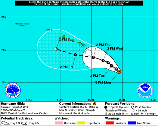
CPHC Hilda 5 pm track August 10, 2015
By Meteorologist Malika Dudley / Email: malika@mauinow.com
Hilda Update:
(5 p.m. 8/10/15)
As of the 5:00 p.m. Central Pacific Hurricane Center update, Hilda still has maximum sustained winds at 90 mph and is a strong Category 1 hurricane. The system is still expected to weaken to a tropical storm sometime tomorrow.
The storm is moving NW near 6 mph and this general motion is expected to continue for the next couple of days.
Hurricane force winds extend 25 miles from the center and tropical storm force winds extend up to 90 miles from the center.
Although Hilda is a compact tropical cyclone, the low level moisture field surrounding the system is pretty broad. This means islands to the east of the track could see an increase in shower activity even if Hilda is several hundred miles away.
In fact, Hilda is now expected to produce heavy rain over portions of the state Thursday and Friday. This type of rainfall could cause flash flooding, mudslide and rockslide conditions. The National Weather Service warns that regardless of the system’s strength, the potential for very heavy rainfall exists for the entire state. Details on timing, location and amount of rainfall are highly dependent on the eventual track Hilda takes.
Other effects include a large swell which is expected to continue for east shores over the next couple of days. A High Surf Advisory remains posted for the east exposures of the Big Island and Maui.
A Hurricane Warning has been issued for Hawaiian offshore waters from 40 nautical miles to 240 nautical miles for high seas and high winds.
Hurricane Hunters will again fly into Hilda this evening to collect important data on the storm.
Hilda Update:
(11 a.m. 8/10/15)
At 11 a.m., Hilda remained a Hurricane and was located about 420 miles SE of Hilo; 515 miles SE of Hāna, Maui; 545 miles SE of Kahului, Maui; 585 miles SE of Kaunakakai, Molokaʻi; and 565 miles SE of Lānaʻi City. The system was moving toward the WNW at 8 mph and had maximum sustained winds of 90 mph.

Satellite imagery for Hilda, 8/10/15. Image credit: NOAA/NWS/CPHC.
The Central Pacific Hurricane Center is forecasting steady weakening of the system over the next 48 hours, with Hilda forecast to weaken into a tropical storm on Tuesday.
Swells associated with Hilda are expected to produce large and potentially life-threatening surf along the east and southeast facing shores of the main Hawaiian Islands over the next couple of days.
Although further weakening is expected, the Hawaiʻi Emergency Management Agency says there is still a 10-15% chance of tropical storm force winds making landfall on Hawaiʻi Island.
Hilda is expected to make its closest approach to Hawaiʻi Island as a tropical depression late Wednesday or early Thursday.
It is important to remember that uncertainty remains surrounding potential impacts in the Hawaiian Islands and potential impacts. The public is advised to closely monitor the progress of Hilda and the CPHC advises that a tropical storm watch may be issued for the Big Island later today or tonight if conditions warrant.
The agency advises that “it is important to to focus too closely on the exact track and intensity forecasts because average intensity errors are near 35 mph on Day 5, and average track errors are near 175 miles. In addition, the hazards of a tropical cyclone can extend over a broad area away from the center.”
***Pacific Media Group News Director Wendy Osher contributed to this report.***
Alerts
A Small Craft Advisory is posted for the Pailolo and ʻAlenuihāhā channels as well as Māʻalaea Bay. Winds of 20 to 25 knots out of the northeast are forecasted with rough seas up to 13 feet. This advisory is posted through 6:00 p.m. Monday. Inexperienced mariners should avoid navigating in these conditions.
A High Surf Advisory is posted for the east side of Maui as swell generated by hurricane Hilda builds. The advisory is posted through 6:00 a.m. Wednesday. Wave heights of 6 to 10 feet are expected Monday, building to 8 to 12 feet Monday night and Tuesday. Expect strong breaking waves, shore break and strong longshore and rip currents making swimming difficult and dangerous.
**Click directly on the images below to make them larger. Charts include: Maui County high/low forecasted temperatures, projected winds, projected localized weather conditions and expected wave heights.**
Today
Today we expect high temperatures from 86° to 91°. Northeast winds are expected today from 10 to 20 mph. Partly sunny skies are forecasted with scattered morning showers for windward and mauka spots and isolated leeward showers.
UV index at 12 (“extreme” exposure level)
Tonight
Northeast winds are expected tonight from 10 to 20 mph. Partly cloudy skies are forecasted with scattered showers for windward spots and isolated showers in leeward areas. Low temperatures from 72° to 77° are expected.
Looking Ahead
Locally breezy trade winds will gradually decrease through Tuesday. For the next few days showers will remain focused along windward slopes. Trade winds will likely hold into Wednesday with a good chance for a gradual increase in shower activity from the east. In addition, a few heavy showers will be possible on Big Island slopes by Wednesday. Heading into the second half of the work week, the local forecast hinges upon the evolution of hurricane Hilda. Forecast uncertainty associated with Hilda remains high. Hilda, or its remnants, will most likely be clearing the state sometime during the weekend.
Our Maui Now Weather homepage always includes daily: Sunrise | Sunset | Moonrise | Moonset | Moon Phase | Live Weather Cams | 5-day Forecast | Current Temperature & Conditions
**Click here for your marine outlook and surf report.**
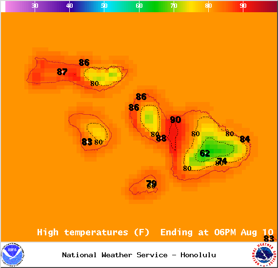
Image: NOAA / NWS
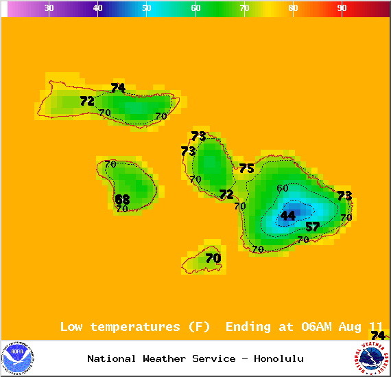
Image: NOAA / NWS
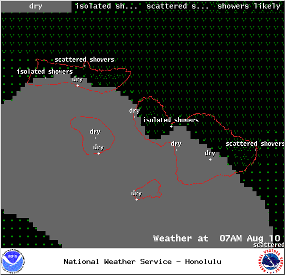
Image: NOAA / NWS
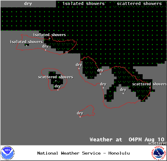
Image: NOAA / NWS
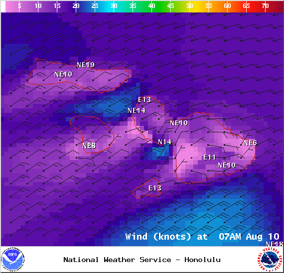
Image: NOAA / NWS
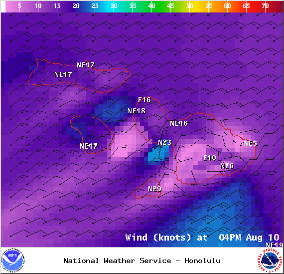
Image: NOAA / NWS
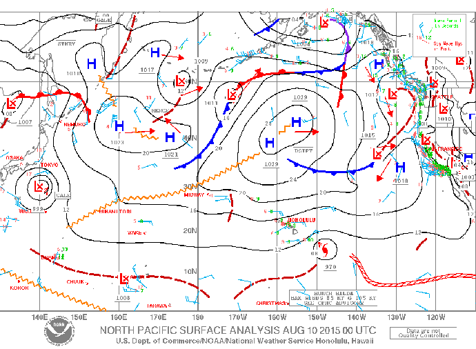
Image: NOAA / NWS
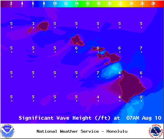
Image: NOAA / NWS
Sponsored Content


