

4:30 pm UPDATE: Niala Weakens, Wind Advisory Canceled

Image: CPHC Niala track at 5 am
***Updated at 4:30 p.m.***
The Wind Advisory has been canceled by the National Weather Service. The High Surf Advisory remains posted for east facing shores with 5 to 8 foot faces expected.
Niala rainfall is not likely to make it as far north as Maui County. However, a band of moisture, remnants of a front, will focus showers across windward slopes, though leeward areas will experience periods of rainfall as well.
***Updated with information from the Central Pacific Hurricane Center’s 5 a.m. bulletin.***
Niala is expected to continue to weaken as it passes south of the state during the next couple of days. The system is currently moving west-southwest near 7 mph and has maximum sustained winds of 50 mph.
Locally windy conditions will persist over Maui County into Monday as strong high pressure remains north of the state, and a Wind Advisory is in effect. Winds of 20 to 30 mph are expected with gusts as high as 50 mph where the terrain accelerates those winds.
We expect a “wet trade wind weather pattern” today with scattered showers favoring windward spots and isolated heavy rain possible. Leeward areas are expected to be partly cloudy with isolated showers.
A High Surf Advisory is also in effect. Large surf will continue to affect the east and southeast shores of Maui County through tomorrow with 6 to 9 foot faces expected today and 5 to 8 foot waves forecast for tomorrow.
Niala’s track has been adjusted only slightly with the general motion continuing in a west-southwest direction.
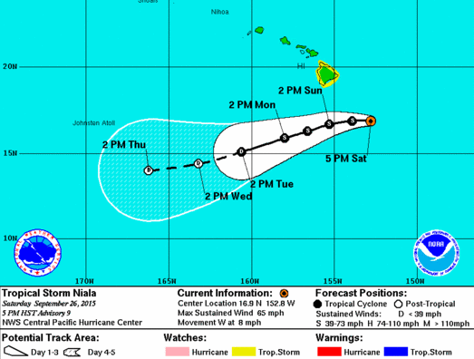
Image: CPHC Niala track at 5 pm
***Updated at 5 p.m.***
By Meteorologist Malika Dudley
Niala’s track remains relatively unchanged since the last update. Maximum sustained winds are near 65 mph making it a solid tropical storm.
The system is projected to move west through Sunday, before taking a southwest turn on Monday. Niala is moving west at 8 mph and expected to pass 120 to 150 miles south of the Big Island Sunday afternoon should it remain on its current track.
The system is being affected by west-southwesterly shear and expected to begin a weakening trend.
Information in the video below remains pertinent to our current situation. Even so, the projected rainfall numbers have dropped a tad to 2-8 inches of rain expected in Hawaii County with up to a foot of rain expected in some spots on the Big Island.
***Updated at 2 p.m.***
Meteorologist Malika Dudley put together this video update which includes important safety information from the forecasters at the Central Pacific Hurricane Center and National Weather Service in Honolulu.
**All storm video footage are from past severe weather events. Mahalo to our storm footage contributors!**
As of the 2 p.m. CPHC update the strong high pressure center far north of Hawaii appears to be gaining influence on Niala with the tight pressure gradient between this and Niala producing windy conditions across Maui County through Sunday night.
Isolated showers, sometimes heavy, are forecast to pass through Maui County. Heaviest rains will most likely occur later tonight and into Sunday along the north and east as enhanced moisture from Niala passes through.
Click here for the latest weather update for Maui County.
Click here for the latest marine outlook for Maui County.
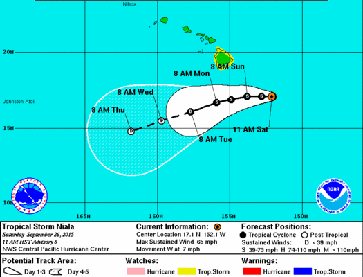
Image: CPHC 11am track Niala
***Updated at 11:10 a.m. to include Central Pacific Hurricane Center information from the 11 a.m. advisory.***
By: Jamilia Epping
As of 11 a.m., Tropical Storm Niala was located about 265 miles southeast of Hilo. The storm was moving in a western direction at seven miles per hour and was holding slightly increased wind speeds of 65 mph.
The Central Pacific Hurricane Center says that Tropical Storm Niala is expected to continue in its current path through Monday. In addition, the storm is expected to slowly weaken.
A High Surf Advisory is posted for east facing shores.(click link for details)
A Wind Advisory is also in effect. (click link for details)
***Original story posted at 7:17 a.m.***
By: Jamilia Epping
Tropical Storm Niala strengthened over night as it nears the Big Island.
As of 5 a.m., the Central Pacific Hurricane Center reported that Tropical Storm Niala was about 280 miles southeast of Hilo, holding maximum sustained winds of 60 miles per hour, and was moving in a northwest direction at seven mph.
Tropical Storm Niala is still expected to make a turn towards the west this weekend. Forward speed is also expected to decrease.
CPHC forecasters say Tropical Storm Niala should pass about 150 miles south of the Big Island Sunday night.
Rain is expected to reach totals of six to 12 inches, with the possibility of up to 16 inches in some areas. The large amount of rain expected could cause life-threatening flash floods, rockslides, and mudslides.
Tropical Storm Niala will produce large surf along southeast shores over the weekend and into next week.
Sponsored Content


