

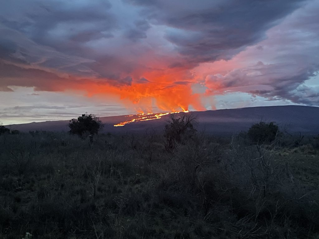
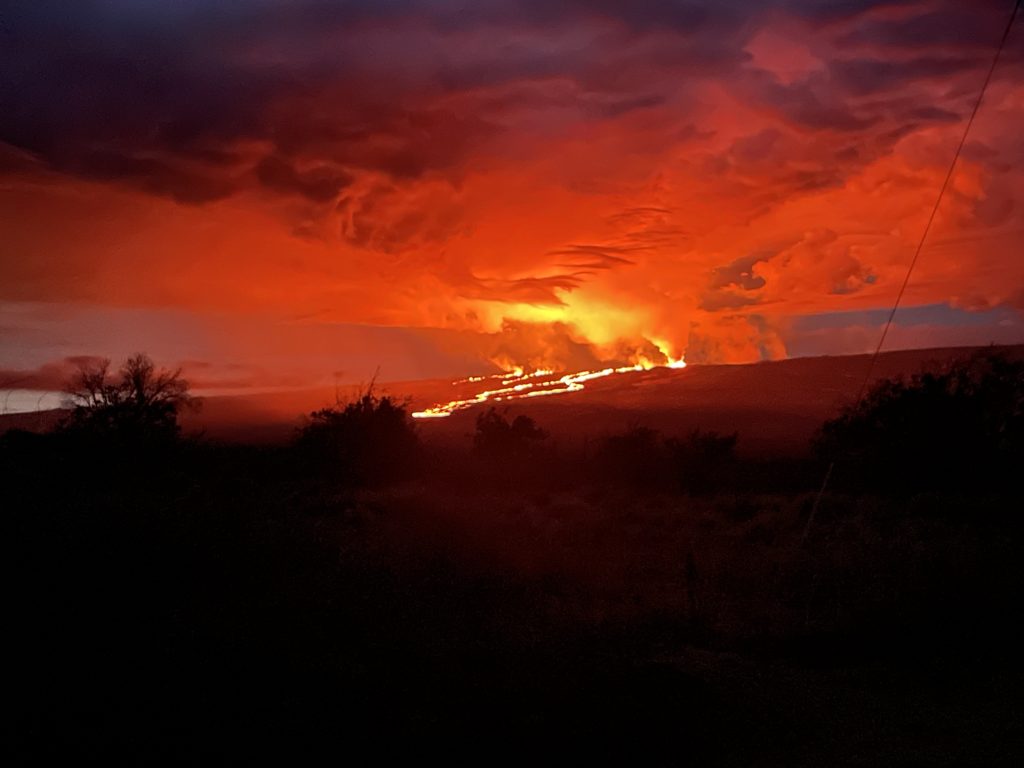
Leading edge of Mauna Loa lava flow crosses Old Kona Highway
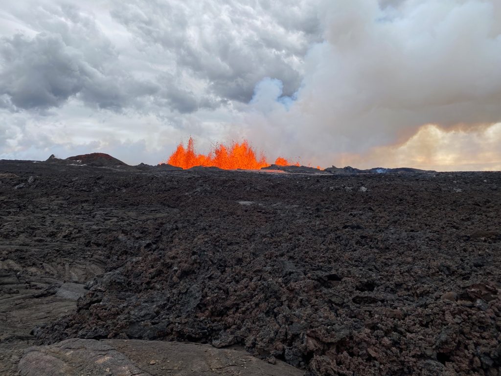
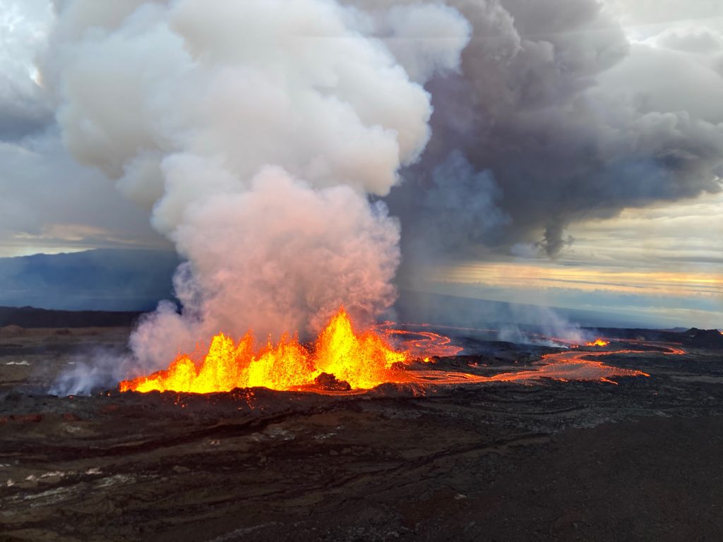
 This image, taken during an early morning overflight on 30 November 2022, shows Fissure 3, the dominant source of activity. As of 7 a.m. HST, the lava fountains are 20-25 meters in height (65-82 feet) and feed a lava flow moving to the northeast at ~130 meters per hour (0.08 miles per hour). PC: USGS/HVO.
- Photograph of a high-definition video camera filming fissure 3. Field crews are out today monitoring the eruption of Mauna Loa. Mauna Kea is in the distance behind the fountaining fissure. Taken at about 7:15 AM on November 30, 2022. PC: USGS/HVO.
- Fissure 3 of the Northeast Rift Zone Mauna Loa eruption with a plume of volcanic gases and fine volcanic ash and Pele’s hair being wafted in a near vertical plume. Taken at about 7:15 AM on November 30, 2022. PC: USGS/HVO
- The Northeast Rift Zone eruption of Mauna Loa has continued into its second full day. At this time two fissures are active, sending lava flows in multiple directions. Overnight satellite views allowed USGS analysts to accurately map some of the most active flows, displayed in red here. Further downslope progression of the flows this morning is marked by dashed lines and points for the flow fronts at 12:00 p.m. today. As of that time, the most downslope flow is within 5.5 miles (9 kilometers) of Saddle Road. PC: HVO/USGS
- Photograph of fissure 3 erupting on Mauna Loa’s Northeast Rift Zone the morning of November 29, 2022. The longest and largest lava flow is issuing from fissure 3. This lava flow crossed the Mauna Loa Weather Observatory Road at approximately 8 p.m. yesterday evening, November 29, and the flow front was located approximately 6 miles (10 km) from Saddle Road at 7 a.m. HST this morning. USGS image by F. Trusdell.
- A view of fissure 4 erupting on the Northeast Rift Zone of Mauna Loa, taken at approximately 8 a.m. HST November 29, 2022. Fissure 4 formed at approximately 7:30 p.m. HST November 28, and this morning the fountains there were 5-10 m (16-33 ft) tall. USGS photo by F. Trusdell.
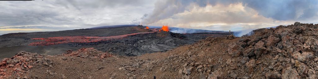
- Aerial photograph of the dominant fissure 3 erupting on the Northeast Rift Zone of Mauna Loa, taken at approximately 8 a.m. HST November 29, 2022. Fissure 3 fountains were up to 25 m (82 ft) this morning and the vent was feeding the main lava flow to the northeast. USGS photo by M. Patrick.
- This image, taken during a helicopter overflight on the afternoon of November 29, shows the advancing flow front from Mauna Loa. This flow was erupted from a vent high up on the Northeast Rift Zone and is flowing to the north. USGS image by L. Gallant.
- Photograph taken from Saddle Road at 6AM Hawaii time on November 29, 2022 shows lava flows moving northeast downslope of Mauna Loa volcano from the Northeast Rift Zone eruption. PC: USGS/HVO
- Photograph taken from Saddle Road at 6AM Hawaii time on November 29, 2022 shows lava flows moving northeast downslope of Mauna Loa volcano from the Northeast Rift Zone eruption. PC: USGS/HVO
- Aerial view of the lava flows on the northeast flank of Mauna Loa, taken during a morning overflight on November 29, 2022. These lava flows are moving in a northeast direction, being fed by fissure vents on the Northeast Rift Zone. USGS photo by M. Patrick.


Seismic activity being monitored;
Flow front is 3 miles from Daniel K Inouye Highway
Update: 9:13 a.m., Wednesday, Nov. 30, 2022
Seismic monitoring from the Hawaiian Volcano Observatory continues to detect tremor (high rates of earthquakes) in the location of the currently active fissures. “This indicates that magma is still being supplied, and activity is likely to continue as long as we see this signal,” according to an HVO update on Wednesday morning.
The County of Hawaiʻi Civil Defense agency reports that the front is about 3 miles from the Daniel K. Inouye Highway, above the 7,000 foot elevation.
At current lava flow rates, the Hawaiʻi EMA says it would take at least 46 hours to reach the road, but the flow will slow more and spread out as it moved onto flatter ground, and there’s also a possibility that it could shift direction.
The agency issued a series of Tweets this morning, including one advising that if state transportation officials decide to close the road, it would take about six hours, allowing for advance notification to the public.
The Northeast Rift Zone eruption of Mauna Loa continues, with two active fissures feeding lava flows downslope, according to the HVO. The fissure 3 lava flows are travelling to the northeast, though the direction shifted slightly westward overnight, still moving toward Saddle Road. Fissure 3 is the dominant source of the largest lava flow, and the flow front is about 3.6 miles (5.8 km) from Saddle Road as of 7 a.m. HST this morning.
“The flows have been advancing at a rate of 0.08 miles per hour (130 meters per hour) over the last day, but they are approaching a relatively flat area and will begin to slow down, spread out, and inflate. Forecasts indicate it may take two days for lava flows to reach Saddle Road,” according to the latest HVO update.
Fissure 4 is still active with lava flows moving toward the northeast at 0.03 miles per hour (50 meters per hour). A small lobe is moving to the east from fissure 4 at a slower rate than the main lobe. Volcanic gas plumes are lofting high and vertically into the atmosphere. Pele’s hair (strands of volcanic glass) is falling in the Saddle Road area.
Leading edge of Mauna Loa lava flow crosses Old Kona Highway
At approximately 11 p.m. Tuesday, the leading edge of the Mauna Loa lava flow crossed Old Kona Highway, a dirt road that crosses the Mauna Loa Forest Reserve. These images show the leading edge of the eruption.
HDOT monitoring Daniel K Inouye Highway in case of Emergency closure
The Hawaiʻi Department of Transportation is monitoring and assessing threats to Daniel K. Inouye Highway (Highway 200/Saddle Road) near the eruption of Mauna Loa.
The highway remains open, but HDOT is monitoring the situation and has plans for messaging in the area and equipment if it becomes necessary to close the heavily used roadway and divert traffic.
Department officials are coordinating with county, state, and federal partners in the Emergency Operation Center on Hawaiʻi Island.
The latest eruption started late Sunday night. A preliminary plan for the possibility of closing the highway can be found here. And the latest from the United States Geological Survey can be found here.

Resources and links:
- The Hawaiʻi County Civil Defense agency has a web page on volcano hazards with maps of inundation zones and hazard zones. Alerts are posted here.
- Hawai‘i Volcanoes National Park has closed the Mauna Loa summit area to visitors.
- Vog information can be found here.
- What does a warning and warning alert level mean? Find out here.
- HVO: Preparing for the next eruption of Earth’s largest active volcano.
- Lava Flows from Mauna Loa (1843-2018)
- Mauna Loa Eruption Response Times over the past 200 years
- Current alerts.
- Mauna Loa webcams.
- Frequently Asked Questions about Mauna Loa Volcano
Sponsored Content


