

UPDATE 8/2/15: Hurricane Guillermo
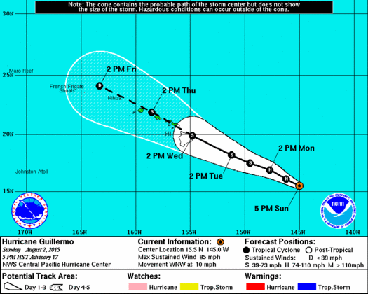
Image: NHC 5 p.m. track on Sunday
By Meteorologist Malika Dudley / Email: malika@mauinow.com
**Updated at 5 p.m.**
Guillermo is still a Category 1 system however maximum sustained winds have dropped to 85 mph. The hurricane is now 835 miles ESE of Kahului, 890 miles ESE of Kaunakakai and 860 miles ESE of Lanai City. As Guillermo moves closer to the islands, watches may be issued as early as Monday for parts of the state. Otherwise, all guidance and forecasts below remain relatively unchanged.
The National Weather Service released this statement regarding the forecast: The latest forecast for Hurricane Guillermo takes the system over the island chain as a tropical storm. While Guillermo is expected to be moving steadily west-northwest as it passes across the island chain, abundant moisture drawn into the circulation will bring the potential for very heavy rainfall and flash flooding on Wednesday and Thursday. The details on the timing, location and amount of rainfall remain uncertain and are highly dependent on the eventual track of Guillermo.
**Click here for hurricane preparedness tips.**

Image: NHC 11 a.m. updated track Sunday 8.2.15
**Updated at 11 a.m.**
The first aircraft from the US 53rd reconnaissance squadron flew through Guillermo to collect data on Hurricane Guillermo this morning. The system has begun to look more ragged and the current intensity has been dropped down a notch to a Category 1 hurricane with maximum sustained winds around 90 mph. The system has also slowed some and is moving west-northwest at 10 mph. Otherwise, the track and general forecast guidance remains unchanged.
**8 a.m. update**
[flashvideo file=http://www.youtube.com/watch?v=Vpib_DGh5SU /]
Hurricane Guillermo is looking a little better organized on satellite this morning. Our stats haven’t changed much since yesterday. Guillermo is still a Category 2 system with maximum sustained winds at 105 mph, moving WNW at 13 mph and about 840 miles ESE of Hilo. Slower forward motion is expected starting later today or tonight.
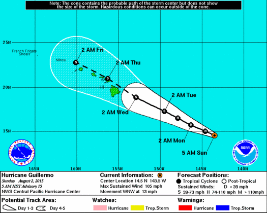
Image: NHC 5 a.m. track Sunday 8.2.15
The track forecast also has not changed much since yesterday. Through day 3 it’s relatively identical – days 4 and 5 the track has been nudged slightly north. The track also brings Guillermo very close to the Hawaiian Islands from Wednesday through Thursday night. It’s more important to focus on the entire forecast cone and not uniquely on the middle line of the track. Track error 96 hours out is still 200 statute miles, looking 120 hours out it’s up to 300 statute miles. It’s still way too soon to make any definite statements on how exactly Guillermo will affect the state and individual islands. Having said that, we expect widespread rain – mainly windward – and periods of strong winds between Wednesday afternoon and Thursday night.
Image: NHC 5 a.m. Sunday 8.2.15
Also, hurricane force winds extend 30 miles from the center and tropical storm force winds extend 115 miles from the center so it’s always good to remember that even if the center of the storm does not make a direct beeline for the islands impacts can extend well away from the center.
How strong is this thing going to be when it gets to us? For now, all indications are that it will be a weakening tropical storm. In about 48 hours Guillermo is expected to encounter unfavorable conditions and start a weakening trend. Keep in mind, tropical storms can still bring strong winds, heavy rain, destructive surf and flooding.

Image: NHC 5 a.m. Sunday 8.2.15
Later this morning the first aircraft from the US 53rd reconnaissance squadron will fly through Guillermo to collect data and give us a better idea of exactly what’s happening. A NOAA aircraft will also be sampling the environment around Guillermo later today.
No watches or warnings are in effect at this time. However, large waves are expected to steadily build for east shores as Guillermo continues to approach. A High Surf Advisory goes into effect at noon today and could be upgraded to a warning depending on conditions.
Sponsored Content


