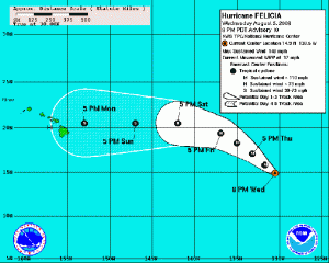
FELICIA UPGRADED TO CATEGORY 4 HURRICANE
UPDATED AT 5:10 P.M. 8/5/09 WEDNESDAY
Hurricane Felicia is now classified as a category 4 hurricane and is moving toward the west-northwest at a rate of about 12 mph. Winds have increased to 140 mph with higher gusts. That places Felicia as a Category Four Hurricane on teh Saffir-Simpson Hurricane Scale. Forecasters with the National Weather Service and National Hurricane Center say Felicia is likely near peak intensity, and weakening is expected during the next couple of days. The system was last tracked at about 1455 miles west-southwest of the southern tip of Baja California.
Hurricane force winds extend outward up to40 miles from the center, and tropical storm force winds extend outward up to 140 miles.
FELICIA FORECAST POSITIONS AND MAX WINDS:
INITIAL 05/1500Z 14.1N 128.7W 100 KT
12HR VT 06/0000Z 15.0N 130.0W 105 KT
24HR VT 06/1200Z 16.4N 131.7W 105 KT
36HR VT 07/0000Z 17.4N 133.2W 100 KT
48HR VT 07/1200Z 18.3N 135.3W 95 KT
72HR VT 08/1200Z 19.9N 140.0W 75 KT
96HR VT 09/1200Z 20.5N 145.3W 65 KT
120HR VT 10/1200Z 20.5N 150.9W 50 KT
ENRIQUE
A burst of overnight convection has improved the forecast for Tropical Storm Enrique. Forecasters from the National Weather Service say this development will soon lead to weakening. There is an indication that the system will rapidly dissipate in about 2 days or less with Enrique’s energy to be absorbed into Felicia.
Enrique is moving toward the Northwest at 17 mph. The system is located about 970 miles west of the southern tip of Baja California. Maximum sustained winds are near 50 mph with higher gusts. Tropical storm force winds extend outward up to 80 miles from the center.
Enrique is expected to weaken and dissipate within the next 48 hours.
ENRIQUE FORECAST POSITIONS AND MAX WINDS:
INITIAL 05/1500Z 17.3N 122.1W 45 KT
12HR VT 06/0000Z 18.4N 124.0W 40 KT
24HR VT 06/1200Z 19.3N 126.3W 30 KT
36HR VT 07/0000Z 19.7N 128.8W 25 KT
48HR VT 07/1200Z 19.7N 131.4W 20 KT…REMNANT LOW
72HR VT 08/1200Z… DISSIPATED
(Posted by Wendy Osher, Information provided by NOAA, The National Weather Service, and the National Hurricane Center)


