Hurricane Warning Issued for Maui, Douglas Closing in on Hawaiian Islands (8 a.m. Update)
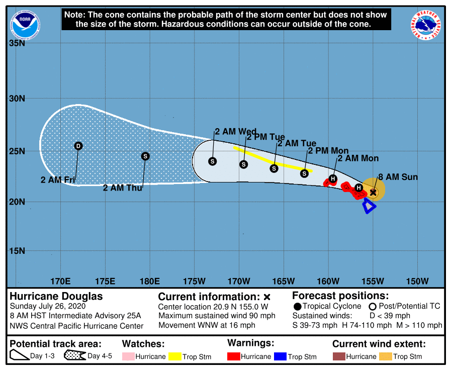
Maui County has been upgraded from a Hurricane Watch to a Hurricane Warning in the latest 8 a.m. update issued by the Central Pacific Hurricane Center. The system has maintained its Category 1 strength with 90 mph sustained winds and higher gusts. As of 8 a.m., Douglas is currently located 90 miles east-northeast of Kahului, Hawaii and 185 miles east of Honolulu.
Peak winds for Molokai are forecast to be 50-65 mph with gusts to 100 mph. Here on Maui, parts on the island will see peak winds of 45-60 mph with gusts to 90 mph for Windward West Maui; and 45-60 mph with gusts to 85 mph for Windward Haleakala, including East Maui.
Peak Rainfall Amounts for Maui and Lanai will be: 3-6 inches, with locally higher amounts; and 4-8 inches, with locally higher amounts on Molokai.
Get your local detailed weather forecast here.
• Hurricane Warning Issued for Maui, Douglas Closing in on Hawaiian Islands (5 a.m. Update)
• 2020 Hurricane Season in Hawaiʻi
• Storm Prep and Kits
• Ige Issues Emergency Proclamation Ahead of Douglas
• Maui Mayor Issues Emergency Proclamation for Hurricane Douglas
• Mayor Victorino urges Maui to Prep for Potential Impacts
• Maui County Emergency Shelter Plans
• Maui Reminded to Conserve Water to Prevent Sewer Spills Due to Hurricane Douglas
• PresidentApproves Emergency Disaster Declaration for Hawaii
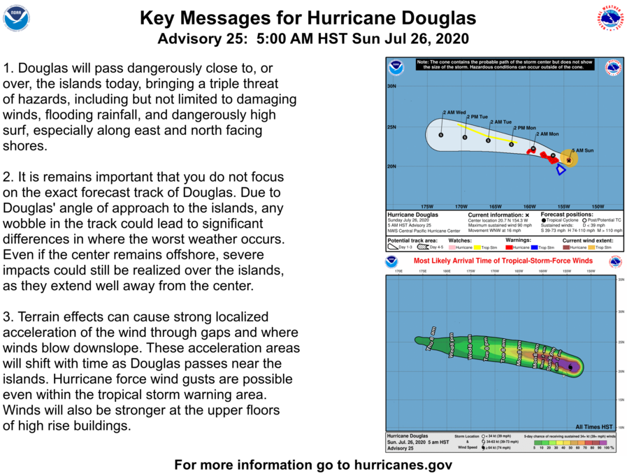
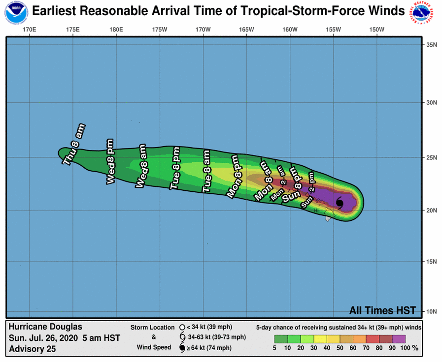
As Hurricane Douglas quickly moves through the area over the next 24 hrs from east to west, expect damaging winds, heavy rainfall, coastal flooding, and life-threatening surf. Douglas is forecast to move near or directly over portions of Maui County and Oahu today into tonight, then Kauai County tonight into Monday. Regardless of the exact track, interests are reminded that impacts can occur well away from the tropical cyclone center. It is also important to note that the mountainous terrain of the islands can cause strong localized accelerations of the wind through gaps and where winds blow downslope.
Total rainfall accumulations of 5 to 10 inches, with locally higher amounts to 15 inches, will be possible as Douglas moves through. While the highest rainfall will favor windward and northern facing slopes, leeward and southern facing slopes could also experience flooding.
Significant coastal impacts are expected due to life-threatening surf along exposed shores. A combination of higher than predicted water levels, storm surge, and surf will lead to significant beach erosion, with water potentially overwashing onto vulnerable low- lying coastal roadways, especially at and around the daily high tides.
Watches/Warnings:
- A Hurricane Warning is in effect for: Maui County, including the islands of Maui, Lanai, Molokai and
Kahoolawe; Oahu; and Kauai County, including the islands of Kauai and Niihau. - A Tropical Storm Warning is in effect for: Hawaii County
- A Tropical Storm Watch is in effect for: Portions of the Papahanaumokuakea Marine National Monument from Nihoa to French Frigate Shoals to Maro Reef.
What it means:
- A Hurricane Warning means that hurricane conditions are expected somewhere within the warning area, in this case within the next 24 hours.
- A Tropical Storm Warning means that tropical storm conditions are expected somewhere within the warning area, in this case within the next 12 hours.
- A Tropical Storm Watch means that tropical storm conditions are possible within the watch area, in this case within the next 36 to 48 hours.
8 a.m. Discussion:
At 800 AM HST (1800 UTC), the center of Hurricane Douglas was located near latitude 20.9 North, longitude 155.0 West. Douglas is moving toward the west-northwest near 16 mph (26 km/h) and this motion is expected to continue over the next couple of days. On the forecast track, Douglas will pass near, or over, the islands from Maui to Kauai today and tonight.
Maximum sustained winds are near 90 mph (150 km/h) with higher gusts. Gradual weakening is forecast during the next 48 hours, but Douglas is expected to remain a hurricane as it moves through the
islands.
Hurricane-force winds extend outward up to 30 miles (45 km) from the center and tropical-storm-force winds extend outward up to 105 miles (165 km).
The estimated minimum central pressure is 987 mb (29.15 inches).
Potential Impacts:
WIND: Hurricane conditions are expected in portions of Maui County today, on Oahu by this afternoon, and on Kauai and Niihau tonight. Tropical Storm conditions are imminent across the Big Island. Due to the steep terrain of the islands, hurricane-force wind gusts are possible even within the tropical storm warning area.
SURF: Large swells generated by Douglas will affect the Hawaiian Islands into Monday, producing life-threatening and potentially destructive surf along exposed shores.
STORM SURGE: The combination of higher than predicted water levels, dangerous storm surge, and large breaking waves will raise water levels by as much as 3 feet above normal tides near the center of Douglas.
RAINFALL: Heavy rainfall associated with Douglas is expected to affect portions of the main Hawaiian Islands from early this morning into Monday. Total rain accumulations of 5 to 10 inches are possible from Maui County westward to Kauai County, with the greatest amounts up to 15 inches in elevated terrain. This rain may result in life-threatening flash flooding and land slides, as well as rapid water level rises on small streams. Douglas could produce an additional 2 to 4 inches of rainfall over the northern half of the Big Island.
*The next intermediate advisory is at 8 a.m. and the next complete advisory will be issued at 11 a.m.


