

Hurricane Douglas Maintains Category 1 Strength, Drawing Closer to Hawaii (8 p.m. Update)
• Hurricane Douglas Maintains Category 1 Strength (8 p.m. Update)
• 2020 Hurricane Season in Hawaiʻi
• Storm Prep and Kits
• Ige Issues Emergency Proclamation Ahead of Douglas
• Maui Mayor Issues Emergency Proclamation for Hurricane Douglas
• Mayor Victorino urges Maui to Prep for Potential Impacts
• Maui County Emergency Shelter Plans
• Maui Reminded to Conserve Water to Prevent Sewer Spills Due to Hurricane Douglas
• PresidentApproves Emergency Disaster Declaration for Hawaii
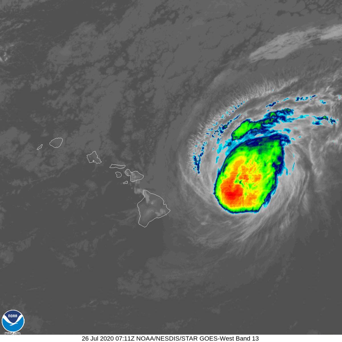
Douglas has maintained its Category 1 status with 90 mph sustained winds, according to the latest 8 p.m. update from the Central Pacific Hurricane Center. The system is now 295 miles ESE of Kahului, Maui and 390 miles ESE of Honolulu. According to the latest imagery produced by the CPHC, a portion of South Maui is no longer included in the cone of uncertainty; however forecasters urge the public not to focus too much on the forecast track.
Maui Specific Highlights:
- Hurricane conditions are possible on Maui County late tonight and Sunday. Tropical storm conditions are also expected late tonight or Sunday.
- Tropical storm winds are 60% probable for Kahului and Hana, and 45% probable for Lanai City.
- Large swells from Douglas will produce hazardous and destructive surf along exposed coasts with storm surge 2 – 4 feet above normal tide near the center of the storm.
- Rainfall of 5 – 10 inches is expected, with high amounts over elevated terrain.
- Life threatening flash flooding and landslides are possible. A flash flood watch is in effect for all islands Sunday morning through Monday afternoon.
“We can’t over emphasize enough that the exact track continues to have some uncertainty; and so a slight change in the forecast track would bring direct impact and landfall across any of the Hawaiian Islands, especially ones that are very close to the track,” said Chris Brenchley, Director of the Central Pacific Hurricane Center.
Maui County remains under a Tropical Storm Warning and a Hurricane Watch.
John Bravender with the Central Pacific Hurricane Center described the potential impacts in Maui County saying, “I believe it’s going to pass, I’d say a little too close for comfort to Maui. One of the concerns with it (we’ve talked about a lot of the hazards. The first thing to increase will be the large surf–damaging surf possibly causing coastal erosion problems; building tonight and Sunday into the peak.”
After that he said there’s a potential for damaging winds from different directions. “With this track passing north of the island, winds swirling around below would come from different directions and potentially cause more damage. Our trees grow into the Tradewinds. They’re used to being in one direction and the wind coming from the other way, it’s easier for them to blow over, so it doesn’t take as much wind to cause damage from these different directions, and a change in direction as the wind would swing around as the tropical cyclone passes by,” said Bravender.
The forecast track of Douglas takes it just north of Oahu–that’s the precise forecast track,” said Robert Ballard, Science and Operations Officer with the Central Pacific Hurricane Center. “But it’s important to remember that at 36 hours we typically have about 55 miles of track error–that’s wider than the island of Oahu. So, Oahu is about 30 miles across. If you drive from the south shore to the north shore. So we can’t say, and I would really stress that–you cannot say that one part of the island is safer than the other at this point. Any part of the islands could experience direct impacts from Maui up to Kauai and Niihau. Anybody could get impacts from this system as it comes through.”
The closest point of approach for Maui is at around 1 p.m. tomorrow, bringing a heavy rain threat and potentially damaging winds.
Updates with this Advisory:
Since the last update, a Tropical Storm Warning was issued for Kauai County, including the islands of Kauai and Niihau. A Tropical Storm Watch has been issued for portions of the Papahanaumokuakea Marine National Monument from Nihoa to French Frigate Shoals.
Below are forecast highlights courtesy of the Central Pacific Hurricane Center:
Warnings and Watches:
- A Hurricane Warning is in effect for Oahu
- A Tropical Storm Warning is in effect for: Hawaii County, Maui County (including the islands of Maui, Lanai, Molokai and Kahoolawe), and Kauai County (including the islands of Kauai and Niihau).
- A Hurricane Watch is in effect for: Hawaii County and Maui County (including the islands of Maui, Lanai, Molokai and Kahoolawe).
What it Means:
- A Hurricane Warning means that hurricane conditions are expected somewhere within the warning area within 36 hours. A Tropical Storm Warning means that tropical storm conditions are expected somewhere within the warning area within 36 hours.
- A Hurricane Watch means that hurricane conditions are possible within the watch area, in this case within the next 36 hours.
- A Tropical Storm Watch means that tropical storm conditions are possible within the watch area, in this case within the next 48 hours.
8 p.m. Forecast Update:
At 8 p.m., the center of Hurricane Douglas was located about 295 miles ESE of Kahului, Maui and 390 miles ESE of Honolulu (near latitude 19.9 North, longitude 151.4 West).
This motion is expected to continue through the next couple of days. On the forecast track, Douglas will be near the main Hawaiian Islands late tonight and is expected move near, or over, parts of the state Sunday and Sunday night.
Maximum sustained winds are near 90 mph with higher gusts. Gradual weakening is expected over the next couple of days. However, Douglas is still forecast to be near hurricane strength when it passes near the islands.
Hurricane-force winds extend outward up to 35 miles from the center and tropical-storm-force winds extend outward up to 115 miles.
Potential impacts:
WIND: Hurricane conditions are expected on Oahu on Sunday and are possible across Maui County and the Big Island on Sunday. Tropical Storm conditions are expected across Hawaii County and Maui County beginning late tonight or Sunday and across Kauai County Sunday night.
SURF: Large swells generated by Douglas are expected to build tonight and affect the Hawaiian Islands Sunday into Monday, and storm surge of 2 to 4 feet above normal tides is expected near the center of Douglas. The large swells and surge will produce life threatening and potentially destructive surf along exposed shores.
RAINFALL: Heavy rainfall associated with Douglas is expected to affect portions of the main Hawaiian Islands from late tonight into Monday. Total rain accumulations of 5 to 10 inches are possible from Maui County westward to Kauai County, with the greatest amounts in elevated terrain. This rain may result in life-threatening flash flooding and land slides, as well as rapid water level rises on small streams. Douglas could produce 2 to 5 inches of rainfall over the northern half of the Big Island.
*An intermediate advisory will be issued at 8 p.m; and the next complete advisory is due out at 11 p.m.

Douglas 8 p.m. 7. 25.20

Douglas. (8 p.m. 7.25.20) PC: NOAA/NWS/CPHC
Douglas. (9 p.m. 7.25.20) PC: NOAA/NWS/CPHC

Douglas (8 p.m. 7.25.20) PC: NOAA/NWS/CPHC
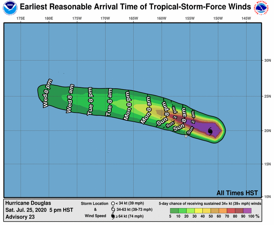
Douglas. (5 p.m. 7.25.20) PC: NOAA/NWS/CPHC
Sponsored Content


